Uploads by DarkShadowTNT
Jump to navigation
Jump to search
For DarkShadowTNT (talk · contributions · Move log · block log · uploads · Abuse filter log)
This special page shows all uploaded files that have not been deleted; for those see the upload log.
| Date | Name | Thumbnail | Size | Description |
|---|---|---|---|---|
| 20:54, 14 July 2024 | UEFA Euro 2024 map.svg (file) |  |
572 KB | ENG runner-up, ESP champion |
| 14:18, 8 February 2024 | Tephra in Grindavík from the February 2024 Sundhnúkar eruption.jpg (file) |  |
352 KB | {{Information |Description={{en|Tephra is frothy and vesicular material which forms when splashes of lava cool quickly in the air in the lava fountaining activity. This process took place when an eruptive fissure opened this morning (8th of February 2024). Due to the tephras‘ vesicularity and lightness it can be transported far within the volcanic plume with wind. It falls in Grindavík now, 3-5 km from the source of formation due to the height of the lava fountains, north-easterly wind-direct... |
| 15:37, 1 February 2024 | Cross section of proposed magma plumbing system beneath the surface of Kīlauea.png (file) |  |
3.04 MB | {{Information |Description={{en|A cross section of proposed magma plumbing system beneath the surface of Kīlauea. “H” marks the Halema‘uma‘u reservoir; “SC” marks the south caldera reservoir; “K” marks the Keanakāko‘i reservoir; “HKIT” notes a connection between the Halema‘uma‘u reservoir and Kīlauea Iki; SWRZ denotes Southwest Rift Zone. The exact depths and geometries of these connections are not well known, but this cross section represents one of the hypothesized configurations.}} |Source... |
| 12:03, 20 August 2023 | 2023 FIFA Women's World Cup map.svg (file) |  |
763 KB | Spain champion, England runner-up |
| 20:37, 30 November 2022 | Lava flow cutting the Mauna Loa Observatory Road.jpg (file) |  |
2.76 MB | {{Information |Description={{en|This image was taken on a helicopter overflight on the afternoon of November 29, 2022. It shows a lava flow cutting across the Mauna Loa Observatory Road in two places.}} |Source=[https://www.usgs.gov/media/images/lava-flow-cutting-mauna-loa-observatory-road United States Geological Survey website] |Date=2022-11-29 |Author=L. Gallant/USGS |Permission={{USGS}} |other_versions= }} Category:2022 eruption of Mauna Loa Category:Mauna Loa Observatory [[Catego... |
| 20:30, 30 November 2022 | Aerial overview of an erupting fissure of the 2022 Mauna Loa eruption.jpg (file) |  |
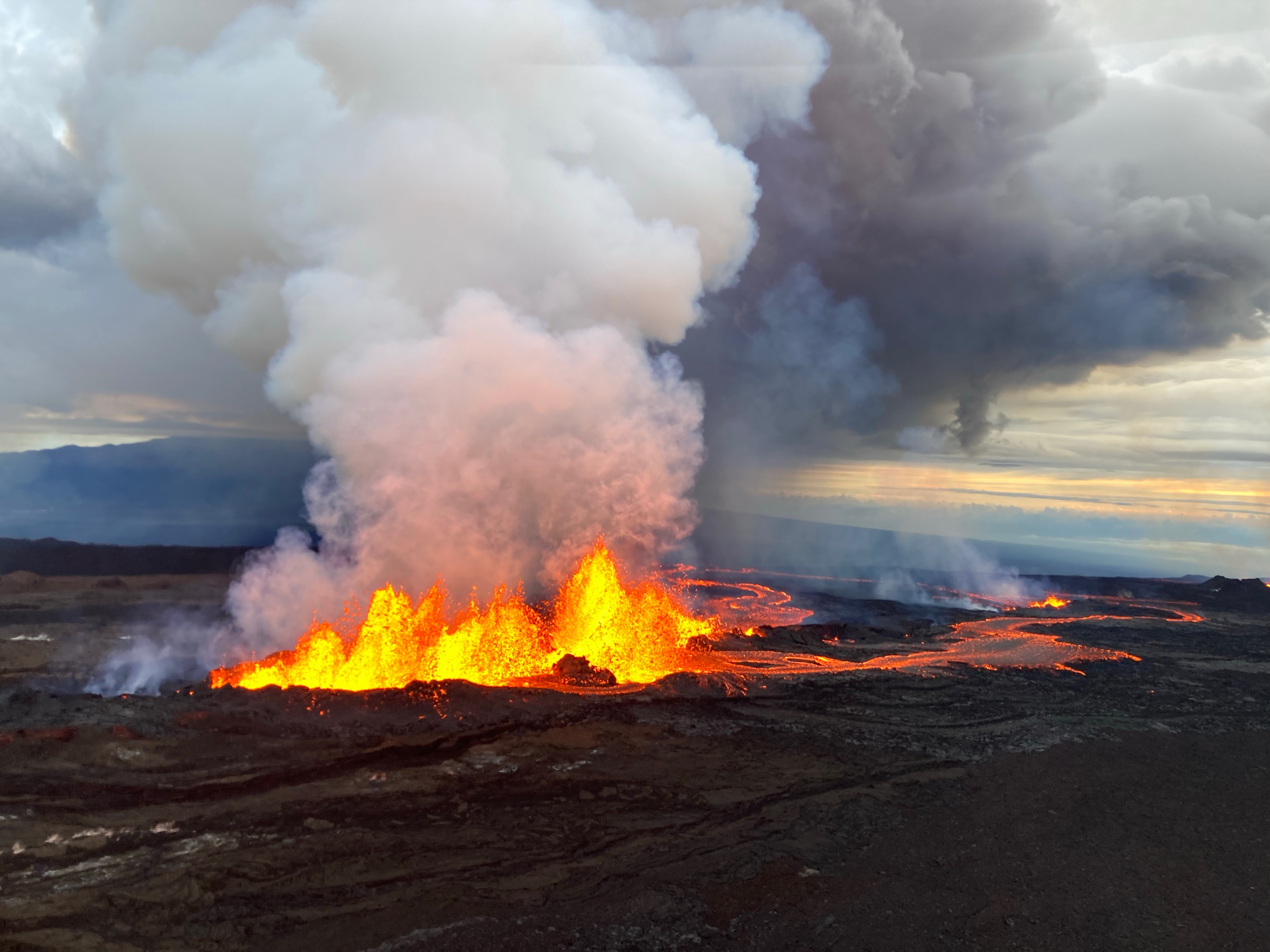
12.99 MB | {{Information |Description={{en|Aerial photo captured during an overflight of the Northeast Rift Zone eruption of Mauna Loa at approximately 5-6:30 p.m. HST on November 28, 2022. This photo shows a braided lava flow on the northeast flank, which is being generated from the line of fissure vents erupting above 10,000 ft elevation on the Northeast Rift Zone of Mauna Loa.}} |Source=[https://www.usgs.gov/media/images/mauna-loa-northeast-rift-zone-eruption-november-28-2022-12 United States Geologi... |
| 20:14, 30 November 2022 | Panorama of fissure 4 of the 2022 Mauna Loa eruption.jpg (file) | 836 KB | {{Information |Description={{en|A view of fissure 4 erupting on the Northeast Rift Zone of Mauna Loa, taken at approximately 8 a.m. HST November 29, 2022. Fissure 4 formed at approximately 7:30 p.m. HST November 28, and this morning the fountains there were 5-10 m (16-33 ft) tall.}} |Source=[https://www.usgs.gov/media/images/november-29-2022-mauna-loa-northeast-rift-zone-eruption United States Geological Survey website] |Date=2022-11-29 |Author=F. Trusdell/USGS |Permission={{USGS}} |other_ver... | |
| 20:08, 30 November 2022 | Lava flow front of the 2022 Mauna Loa eruption.jpg (file) |  |
1.53 MB | {{Information |Description={{en|A Hawaiian Volcano Observatory geologist documents a lava flow from the Northeast Rift Zone of Mauna Loa the morning of November 29, 2022. The ‘a‘ā lava flow, on the northeast flank of Mauna Loa, is several feet thick. 'A'ā flows have a rough rubbly surface composed of broken lava blocks called clinkers. The clinkery surface covers a massive dense core, which is the most active part of the flow. As pasty lava in the core travels downslope, the clinkers are carr... |
| 22:29, 29 November 2022 | Fissure 3 of the 2022 Mauna Loa eruption closeup.jpg (file) |  |
994 KB | {{Information |Description={{en|Aerial photograph of the dominant fissure 3 erupting on the Northeast Rift Zone of Mauna Loa, taken at approximately 8 a.m. HST November 29, 2022. Fissure 3 fountains were up to 25 m (82 ft) this morning and the vent was feeding the main lava flow to the northeast.}} |Source=[https://www.usgs.gov/media/images/november-29-2022-mauna-loa-northeast-rift-zone-eruption-0 United States Geological Survey website] |Date=2022-11-29 |Author=M. Patrick/USGS |Permission={{... |
| 00:44, 29 November 2022 | 2022 Mauna Loa eruption start.webm (file) | 6.3 MB | Imported media from https://d9-wret.s3.us-west-2.amazonaws.com/assets/palladium/production/s3fs-public/media/video/Mauna%20Loa%20Eruption.mp4 | |
| 17:55, 28 November 2022 | 2022 northeast rift zone eruption of Mauna Loa.jpg (file) |  |
400 KB | {{Information |Description={{en|Aerial photos taken at 7:15 AM local time (HST) from Civil Air Patrol flight. Northeast rift zone eruption of Mauna Loa.}} |Source=[https://www.usgs.gov/media/images/lava-flow-northeast-rift-zone-eruption-mauna-loa United States Geological Survey website] |Date=2022-11-28 |Author=Natalie Deligne, USGS |Permission={{USGS}} |other_versions= }} Category:2022 eruption of Mauna Loa |
| 17:52, 28 November 2022 | 2022 Mauna Loa eruption as viewed from Waikoloa.jpg (file) |  |
302 KB | {{Information |Description={{en|Mauna Loa eruption as viewed from Waikoloa at about 1:25am local time (HST). The eruption is occurring from the summit of the volcano, though lava has overflowed the caldera.}} |Source=[https://www.usgs.gov/media/images/mauna-loa-eruption-viewed-waikoloa United State Geological Survey website] |Date=2022-11-28 |Author=en:United States Geological Survey |Permission={{USGS}} |other_versions= }} Category:2022 eruption of Mauna Loa |
| 12:58, 27 May 2020 | Bertha 2020-05-27 1210Z.jpg (file) |  |
1,005 KB | {{Information |Description={{en|Tropical Storm Bertha at 2020-05-27 1210Z, as captured by GOES-East.}} |Source=[https://www.star.nesdis.noaa.gov/GOES/fulldisk.php?sat=G16 GOES Image Viewer] ([http://web.archive.org/web/20200527125510/https://cdn.star.nesdis.noaa.gov/GOES16/ABI/FD/GEOCOLOR/20201481210_GOES16-ABI-FD-GEOCOLOR-10848x10848.jpg archived original image]) |Date=2020-05-27 |Author=GOES-East |Permission={{PD-USGov-NOAA}} |other_versions= }} Category:Tropical Storm Bertha (2020) |
| 21:50, 15 March 2020 | Norberto 2020-03-05 1350Z.jpg (file) |  |
1.78 MB | {{Information |Description={{en|Storm Norberto, of the 2019-20 European windstorm season, covering much of Europe on 5 March 2020.}} |Source=[https://go.nasa.gov/38UhgOK EOSDIS Worldview] |Date=2020-03-05 |Author=EOSDIS Worldview — Suomi NPP/VIIRS |Permission= |other_versions= }} Category:2019-20 European windstorm season |
| 21:46, 15 March 2020 | Myriam 2020-03-02 1628Z.jpg (file) |  |
5.05 MB | {{Information |Description={{en|Storm Myriam, of the 2019-20 European windstorm season, above the Atlantic Ocean on 2 March 2020.}} |Source=[https://go.nasa.gov/2IOv5nd EOSDIS Worldview] |Date=2020-03-02 |Author=EOSDIS Worldview — Suomi NPP/VIIRS |Permission= |other_versions= }} Category:2019-20 European windstorm season |
| 21:39, 15 March 2020 | Leon 2020-03-01 1054Z.jpg (file) |  |
486 KB | {{Information |Description={{en|Storm Leon, of the 2019-20 European windstorm season, covering France on 1 March.}} |Source=[https://go.nasa.gov/2xHJJdJ EOSDIS Worldview] |Date=2020-03-01 |Author=EOSDIS Worldview — Terra/MODIS |Permission= |other_versions= }} Category:2019-20 European windstorm season |
| 21:33, 15 March 2020 | Karine 2020-03-02 1306Z.jpg (file) |  |
1.44 MB | {{Information |Description={{en|Storm Karine, of the 2019-20 European windstorm season, covering much of southern Europe on 2 March 2020.}} |Source=[https://go.nasa.gov/2vorSrr EOSDIS Worldview] |Date=2020-03-02 |Author=EOSDIS Worldview — Suomi NPP/VIIRS |Permission= |other_versions= }} Category:2019-20 European windstorm season |
| 21:20, 15 March 2020 | 2019-20 European windstorm season summary map.png (file) |  |
7.56 MB | Update to 2020-03-15 1800Z; all storms formed between 25 February and 3 March final (Jorge through Norberto) |
| 21:16, 15 March 2020 | Norberto 2020 track.png (file) |  |
448 KB | Update to OPC final 2020-03-06 0600Z; Met Office final 2020-03-07 1800Z |
| 22:47, 5 March 2020 | Myriam 2020 track.png (file) |  |
456 KB | {{WPTC track map | author = DarkShadowTNT | name = Storm Myriam | article = 2019-20 European windstorm season#Storm Myriam | season = 2019-20 European windstorm season | start = 2020-02-29 | end = 2020-03-05 | othersource=[https://ocean.weather.gov/ OPC] and Met Office using charts archived by [http://www1.wetter3.de/archiv_ukmet_dt.html Wetter3]. Wind speed data is from [https://www.ventusky.com Ventusky], using GFS. | catname=2019-20 European windstorm season track maps | code= AL1... |
| 22:45, 5 March 2020 | Karine 2020 track.png (file) |  |
750 KB | Update to Met Office final 2020-03-04 0600Z |
| 22:41, 5 March 2020 | Jorge 2020 track.png (file) |  |
328 KB | Update to OPC 2020-03-03 1200Z; Met Office 2020-03-03 1800Z-2020-03-04 0000Z; OPC 2020-03-04 0600Z-2020-03-05 1800Z |
| 00:12, 3 March 2020 | Leon 2020 track.png (file) |  |
294 KB | {{WPTC track map | author = DarkShadowTNT | name = Storm Leon | article = 2019-20 European windstorm season#Storm Leon | season = 2019-20 European windstorm season | start = 2020-02-29 | end = 2020-03-01 | othersource=[https://ocean.weather.gov/ OPC]. Wind speed data is from [https://www.ventusky.com Ventusky], using GFS. | catname=2019-20 European windstorm season track maps | code= AL162020, LEON, 8, 20200229, 0000, G, EX, 47.1N, 41.9W, 40, 999, 0, 0,... |
| 19:17, 29 February 2020 | Jorge 2020-02-29 1347Z.jpg (file) |  |
2.54 MB | {{Information |Description={{en|Storm Jorge, of the 2019-2020 European windstorm season, approaching the British Isles on 29 February 2020.}} |Source=[https://go.nasa.gov/39dYKSj EOSDIS Worldview] |Date=2020-02-29 |Author=EOSDIS Worldview — Suomi/NPP |Permission= |other_versions= }} Category:2019-20 European windstorm season |
| 00:01, 15 February 2020 | Dennis 2020-02-14 1600Z.jpg (file) |  |
9.71 MB | {{Information |Description={{en|Storm Dennis, of the 2019-20 European windstorm season, above the Atlantic Ocean with its 'tail' flanking the North American coastline on 14 February 2020.}} |Source=[https://www.star.nesdis.noaa.gov/GOES/fulldisk.php?sat=G16 NOAA STAR GOES-16 page] ([http://web.archive.org/web/20200214235812/https://cdn.star.nesdis.noaa.gov/GOES16/ABI/FD/GEOCOLOR/20200451600_GOES16-ABI-FD-GEOCOLOR-10848x10848.jpg archived]) |Date=2020-02-14 |Author=NOAA GOES-16 (GOES-East) Ful... |
| 23:39, 14 February 2020 | Ines 2020 track.png (file) |  |
415 KB | Update to OPC final 2020-02-14 0000Z; Met Office 2020-02-14 1800Z |
| 22:16, 12 February 2020 | Ines 2020-02-12 1243Z.jpg (file) |  |
1.59 MB | {{Information |Description={{en|Storm Ines, of the 2019-20 European windstorm season, approaching Ireland on 12 February 2020.}} |Source=[https://go.nasa.gov/2vs6MIe EOSDIS Worldview] |Date=2020-02-12 |Author=EOSDIS Worldview — Terra/MODIS |Permission= |other_versions= }} Category:2019-20 European windstorm season |
| 19:33, 12 February 2020 | Ciara 2020 track.png (file) |  |
502 KB | Update to Met Office final 2020-02-12 0000Z |
| 23:15, 7 February 2020 | Ciara 2020-02-07 1800Z.jpg (file) |  |
10.25 MB | {{Information |Description={{en|Storm Ciara, of the 2019-20 European windstorm season, at the western coast of the American continent on 7 February. Cut from the original, which has been [http://web.archive.org/web/20200207231338/https://cdn.star.nesdis.noaa.gov/GOES16/ABI/FD/GEOCOLOR/20200381800_GOES16-ABI-FD-GEOCOLOR-10848x10848.jpg archived].}} |Source=[https://www.star.nesdis.noaa.gov/GOES/fulldisk.php?sat=G16 NOAA STAR GOES page] |Date=2020-02-07 |Author=NOAA GOES-16 (GOES-East) Fulldisk... |
| 22:39, 6 February 2020 | Herve 2020 track.png (file) |  |
872 KB | Fix track |
| 22:03, 6 February 2020 | Herve 2020-02-04 1129Z.jpg (file) |  |
626 KB | {{Information |Description={{en|Storm Herve, of the 2019-2020 European windstorm season, covering much of eastern Europe on 4 February 2020.}} |Source=[https://go.nasa.gov/2S2CkgK EOSDIS Worldview] |Date=2020-02-04 |Author=EOSDIS Worldview — Suomi NPP/VIIRS |Permission= |other_versions= }} Category:2019-20 European windstorm season |
| 00:31, 22 January 2020 | Gloria 2020-01-17 1350Z.jpg (file) |  |
1.69 MB | {{Information |Description={{en|Storm Gloria, of the 2019-2020 European windstorm season, above the Atlantic Ocean. The cloud band left-bottom is from an unrelated storm.}} |Source=[https://www.star.nesdis.noaa.gov/GOES/fulldisk.php?sat=G16 NOAA STAR GOES-16 page] |Date=2020-01-17 |Author=NOAA GOES-16 (GOES-East) Fulldisk GeoColor |Permission={{PD-USGov-NOAA}} |other_versions= }} Category:2019-20 European windstorm season |
| 20:57, 21 January 2020 | Gloria 2020 track.png (file) |  |
355 KB | {{WPTC track map | author = DarkShadowTNT | name = Storm Gloria | article = 2019-20 European windstorm season#Storm Gloria | season = 2019-20 European windstorm season | start = 2020-01-15 | end = 2020-01-20 | othersource=[https://ocean.weather.gov/past_products.php OPC]. Wind speeds from [https://www.ventusky.com Ventusky] using GFS. | catname=2019-20 European windstorm season track maps | code= AL092020, GLORIA, 22, 20200115, 0000, G, EX, 38.2N, 73.8W, 20, 1016,... |
| 18:25, 21 January 2020 | Brendan 2020 track.png (file) |  |
370 KB | Update to OPC final 2020-01-15 1800Z; Met Office final 2020-01-17 0000Z. |
| 18:03, 14 January 2020 | Brendan 2020-01-13 0337Z.jpg (file) |  |
1.55 MB | {{Information |Description={{en|Storm Brendan, of the 2019-20 European windstorm storm season, above the Atlantic Ocean.}} |Source=[https://go.nasa.gov/2NpTTog EOSDIS Worldview] |Date=2020-01-13 |Author=EOSDIS Worldview — Suomi NPP/VIIRS |Permission= |other_versions= }} Category:2019-20 European windstorm season |
| 15:51, 23 December 2019 | Fabien 2019 track.png (file) |  |
496 KB | update to OPC 2019-12-23 1200Z |
| 15:49, 23 December 2019 | Elsa 2019 track.png (file) |  |
350 KB | update to OPC final 2019-12-21 1200Z; correct track |
| 18:31, 21 December 2019 | Daniel 2019 track.png (file) |  |
735 KB | Add wind speeds |
| 17:09, 21 December 2019 | Atiyah 2019 track.png (file) |  |
465 KB | Add wind speeds |
| 16:47, 21 December 2019 | Cecilia 2019 track.png (file) |  |
283 KB | Add wind speeds |
| 16:29, 21 December 2019 | Bernardo 2019 track.png (file) |  |
684 KB | Add wind speeds |
| 14:52, 21 December 2019 | Amelie 2019 track.png (file) |  |
292 KB | Add wind speeds |
| 01:10, 21 December 2019 | Fabien 2019-12-20 1200Z.jpg (file) |  |
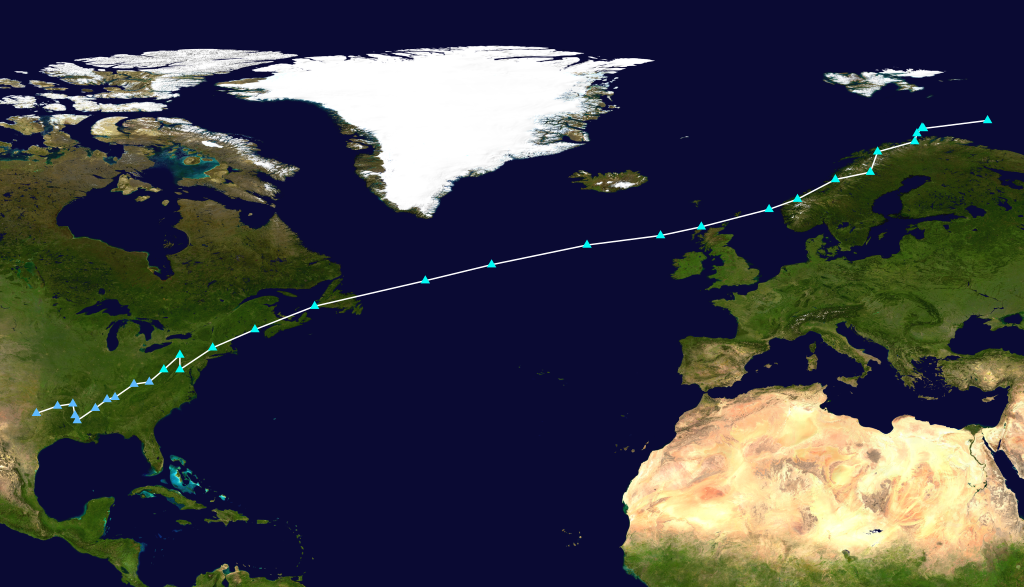
9.71 MB | {{Information |Description={{en|Storm Fabien, of the 2019-20 European windstorm season, above the Atlantic Ocean. Note: on the original, fulldisk image ([http://web.archive.org/web/20191221010640/https://cdn.star.nesdis.noaa.gov/GOES16/ABI/FD/GEOCOLOR/20193541200_GOES16-ABI-FD-GEOCOLOR-10848x10848.jpg archived]), a green-blue curve of pixels is present, spanning east of Greenland to about half-way the Pacific. This was not added by the editing software used.}} |Source=[https://www.star.nesdis... |
| 22:44, 20 December 2019 | Elsa 2019-12-18 1313Z.jpg (file) |  |
3.43 MB | {{Information |Description={{en|Storm Elsa, of the 2019-20 European windstorm season, near the British Isles on 18 December 2019.}} |Source=[https://go.nasa.gov/35NilqM EOSDIS Worldview] |Date=2019-12-18 |Author=EOSDIS Worldview — Suomi NPP/VIIRS |Permission= |other_versions= }} Category:2019-20 European windstorm season |
| 21:10, 20 December 2019 | Daniel 2019-12-16 1346Z.jpg (file) |  |
844 KB | {{Information |Description={{en|Storm Daniel, part of the 2019-20 European windstorm season, nearing the Iberian Peninsula on 16 December 2019.}} |Source=[https://go.nasa.gov/370gDSX EOSDIS Worldview] |Date=2019-12-16 |Author=EOSDIS Worldview — Suomi NPP/VIIRS |Permission= |other_versions= }} |
| 21:06, 7 December 2019 | Atiyah 2019-12-07 1150Z.jpg (file) |  |
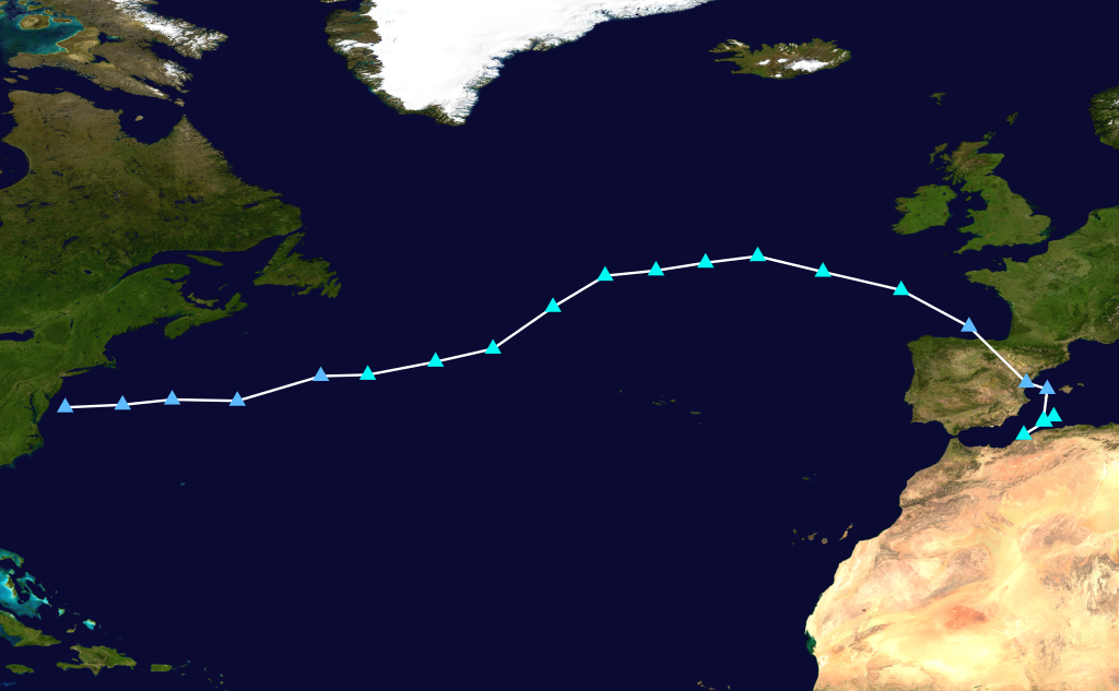
8 MB | {{Information |Description={{en|Storm Atiyah, part of the 2019-20 European windstorm season, above the Atlantic Ocean, with the core just south of Greenland. Note: on the original image, a green-blue curve of pixels is present, spanning east of Greenland to about half-way the Pacific. This was not added by the editing software used.}} |Source=[https://www.star.nesdis.noaa.gov/GOES/fulldisk.php?sat=G16 NOAA STAR GOES page] |Date=2019-12-07 |Author=NOAA GOES-16 (GOES-East) Fulldisk GeoColor |Pe... |
| 21:06, 22 November 2019 | Cecilia 2019-11-22 1118Z.jpg (file) |  |
883 KB | Upon 'closer' inspection, the swirl on the previous version but a small part of Cecilia. This is the actual storm. |
| 17:23, 3 November 2019 | Amelie 2019-11-02 1416Z.jpg (file) |  |
520 KB | {{Information |Description={{en|Storm Amelie, of the 2019-2020 European windstorm season, above the Atlantic Ocean.}} |Source=[https://go.nasa.gov/33dYRu5 EOSDIS Worldview] |Date=2019-11-02 |Author=EOSDIS Worldview — Suomi NPP/VIIRS |Permission= |other_versions= }} Category:2019-20 European windstorm season |
| 19:21, 2 October 2019 | Lorenzo 2019-10-02 1226Z.jpg (file) |  |
1.39 MB | {{Information |Description={{en|Storm Lorenzo, of the 2019-2020 European windstorm season, after passing the Azores. The storm consists out of hurricane Lorenzo's remnants, of the 2019 Atlantic hurricane season.}} |Source=[https://go.nasa.gov/2pt95Ib EOSDIS Worldview] |Date=2019-10-02 |Author=EOSDIS Worldview — Terra/MODIS |Permission= |other_versions= }} Category:2019-20 European windstorm season |
| 12:49, 30 September 2019 | Lorenzo 2019-09-30 1228Z.jpg (file) |  |
2.54 MB | {{Information |Description={{en|Hurricane Lorenzo, of the 2019 Atlantic hurricane season, above the Atlantic ocean}} |Source=[https://www.star.nesdis.noaa.gov/GOES/index.php GOES-East] |Date=2019-09-30 |Author=NOAA |Permission= |other_versions= }} == {{int:license-header}} == {{PD-USGov-NOAA}} Category:Hurricane Lorenzo (2019) |