Kullu Manali Circuit
Jump to navigation
Jump to search
Kullu Manali Circuit
[edit]
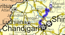
The initial entry point to Kullu Manali Circuit is from Chandigarh, India. Most of the stopovers and destinations lies on the National Highway No. 3 (former NH 21). This highway originates from Chandigarh and ends at Manali. This path from Chandigarh to Manali followed by National Highway No 3 (former NH 21). is the Kullu Manali Circuit. It is categorised into 4 main trails:-
- Sutlej Trail
- Beas Trail
- Kullu Valley Trail
- Across Rohtang Pass
June 2004
[edit]National Highway 3 (former NH 21)
[edit]-
Baglamukhi Temple, Pandoh 2004-06-23 04:04:53
-
Baglamukhi Temple, Pandoh
-
2004-06-23 06:12:48
July 2004
[edit]Ugyen Sanag Choling Monastery (Kungri, near Kulu)
[edit]བོད་ཡིག: ཨོ་རྒྱན་གསང་སྔགས་ཆོས་གླིང་།
in 2004 at the new Urgyen Sanag Choling Gompa (dedicated by H.H. The Dalai Lama on 8 June, 2004), near Kulu, H.P., India
-
Pin gompa 2004-07-01 02:45
-
Pin gompa 2004-07-01 02:46
-
Pin gompa 2004-07-01 03:01:39
-
Pin gompa
From Manali to Manikaran
[edit]-
2004-07-05 23:00:41
-
2004-07-05 23:51:53
-
Kaïs Monastery 2004-07-07 00:24:49
-
Kaïs Monastery 2004-07-07 00:27
-
Kaïs Monastery 2004-07-07 00:27:41
-
Kaïs, Maa Dasmi Varda Temple 2004-07-07 01:24:29
-
2004-07-07 06:30
-
2004-07-07 07:28
-
2004-07-07 07:31
-
2004-07-07 07:44:40
-
2004-07-07 07:48
-
2004-07-07 07:48:07
-
2004-07-07 07:48:07
-
2004-07-07 08:03:36
-
2004-07-07 21:49
-
Manikaran road 2004-07-07 21:52
-
Manikaran road 2004-07-07 22:55:56
-
Manikaran road 2004-07-07 22:58:57
From Kullu city to Manali
[edit]-
Raghunath Temple, Kullu 2004-07-08 00:02
-
Raghunath Temple, Kullu 2004-07-08 00:03:20
-
Raghunath Temple, Kullu 2004-07-08 00:04
-
Raghunath Temple, Kullu 2004-07-08 00:04:14
-
Raja Rupi Kulu Palace 2004-07-08 00:11
-
Bandrole 2004-07-08 00:56
-
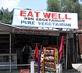
Eat Well Dhaba, Bandrole 2004-07-08 00:58
-
Eat Well Dhaba, Bandrole
-
2004-07-08 04:07:29
-
2004-07-08 06:11:48
-
2004-07-09 01:23
-
2004-07-09 02:28
-
2004-07-11 06:30
-
2004-07-11 06:36:56
1 january 2005
[edit]Hidimba Devi Temple (Old Manali)
[edit]| Object location | | View all coordinates using: OpenStreetMap |
|---|
-
Hidimba Devi Temple 2005-01-01 12:01:13
-
2005-01-01 12:01:41
-
Hidimba Devi Temple 2005-01-01 12:07:13
-
2005-01-01 12:07:49
-
2005-01-01 12:08:13
-
2005-01-01 12:08:25
-
2005-01-01 12:08:43
-
Ghatothkach Shrine 2005-01-01 12:10:22
-
Ghatothkach Shrine 2005-01-01 12:11:06
-
Ghatothkach Shrine 2005-01-01 12:11:18
-
2005-01-01 12:11:33
-
2005-01-01 12:11:44
-
Museum of Himachal Culture & Folk Art 2005-01-01 12:12:03
-
Museum of Himachal Culture & Folk Art 2005-01-01 12:12:12
-
2005-01-01 12:24:54
-
2005-01-01 12:25:05
Shiv Temple (Old Manali)
[edit]-
2005-01-01 12:36:32
-
2005-01-01 12:36:43
-
2005-01-01 12:36:53
-
2005-01-01 12:37:05
-
2005-01-01 12:37:15
-
2005-01-01 12:38:23
-
2005-01-01 12:38:36
-
2005-01-01 12:39:11
-
2005-01-01 12:39:45
-
2005-01-01 12:39:56
-
2005-01-01 12:41:42
-
2005-01-01 12:41:52
-
2005-01-01 12:42:01
-
2005-01-01 12:43:43
-
2005-01-01 12:48:18
-
2005-01-01 12:48:28
-
2005-01-01 12:49:49
-
2005-01-01 12:49:58
-
2005-01-01 12:50:28
-
2005-01-01 12:50:39
-
2005-01-01 12:50:50
-
2005-01-01 12:51:29
Nyingmapa Tibetan Buddhist Monastery (Manali)
[edit]-
2005-01-01 13:23:53
-
2005-01-01 12:00:15
-
2005-01-01 12:00:33
-
2005-01-01 12:00:13
-
2005-01-01 12:00:18
-
2005-01-01 12:00:15
-
2005-01-01 12:00:32
-
2005-01-01 12:00:14
28 january 2006
[edit]Manali
[edit]HOTEL RIVER WEST (Kanyal Road, Simsa Village, near Manali)
[edit]| Object location | | View all coordinates using: OpenStreetMap |
|---|
-
2006-01-28 11:00:27
-
2006-01-28 11:00:40
-
2006-01-28 11:00:50
-
2006-01-28 11:01:01
-
2006-01-28 11:01:10
-
2006-01-28 11:32:55
-
2006-01-28 11:33:11
-
2006-01-28 11:33:22
-
2006-01-28 11:33:34
-
2006-01-28 11:33:44
-
2006-01-28 11:33:56
-
2006-01-28 11:35:21
-
2006-01-28 11:35:32
-
2006-01-28 11:39:52
-
2006-01-28 11:40:02
-
2006-01-28 11:40:12
-
2006-01-28 11:40:24
-
2006-01-28 11:40:42
-
2006-01-28 11:40:54
Snowy mountains
[edit]-
2006-01-28 12:40:58
-
2006-01-28 12:41:10
-
2006-01-28 12:41:20
-
2006-01-28 12:41:32
-
2006-01-28 12:41:43
-
2006-01-28 12:41:54
-
2006-01-28 12:42:05
-
2006-01-28 12:42:16
Solang Valley
[edit]-
Solang 2006-01-28 13:27:01
-
Solang 2006-01-28 13:27:14
-
Solang 2006-01-28 13:27:24
-
Solang 2006-01-28 13:27:36
-
Solang 2006-01-28 13:27:48
-
Solang 2006-01-28 13:48:23
-
Solang 2006-01-28 13:48:33
-
Solang 2006-01-28 13:48:46
-
Solang 2006-01-28 13:48:57
-
Solang 2006-01-28 13:49:09
-
Solang 2006-01-28 13:49:17
29 january 2006
[edit]HOTEL RIVER WEST
[edit]-
2006-01-29 09:22:33
-
2006-01-29 09:22:53
-
2006-01-29 09:23:02
Harisons Filling Station ( Indian Oil Petrol Pump )
[edit]National Highway 21, Simsa Village, near Manali
| Object location | | View all coordinates using: OpenStreetMap |
|---|
-
2006-01-29 10:10:42
-
2006-01-29 10:10:56
-
2006-01-29 10:11:07
-
2006-01-29 10:11:14
-
2006-01-29 10:11:48
Hot Water Springs of Manikaran
[edit]-
2006-01-29 13:30:54
-
2006-01-29 13:31:32
-
2006-01-29 13:33:04
-
2006-01-29 13:33:15
-
2006-01-29 13:33:30
-
2006-01-29 13:33:53
-
2006-01-29 13:34:34
-
2006-01-29 13:35:32
-
2006-01-29 13:35:45
-
2006-01-29 13:36:08
-
2006-01-29 13:36:17
-
2006-01-29 13:39:35
-
2006-01-29 13:39:49
-
2006-01-29 13:40:05
-
2006-01-29 13:40:22
-
2006-01-29 13:40:34
-
2006-01-29 13:40:44
-
2006-01-29 13:41:50
-
2006-01-29 13:42:08
-
2006-01-29 13:44:40
-
2006-01-29 13:44:56
-
2006-01-29 13:49:41
-
2006-01-29 13:49:56
-
2006-01-29 13:50:48
-
2006-01-29 13:51:01
-
2006-01-29 13:52:56
-
2006-01-29 13:53:10
-
2006-01-29 14:26:26
-
2006-01-29 14:36:45
-
2006-01-29 14:37:15
-
2006-01-29 14:40:30
-
2006-01-29 14:41:23
-
2006-01-29 14:42:00
-
2006-01-29 14:42:36
-
2006-01-29 14:42:52
-
2006-01-29 14:43:03
-
2006-01-29 14:44:37
-
2006-01-29 14:45:02
-
2006-01-29 14:45:18
-
2006-01-29 14:45:34
30 january 2006
[edit]Beas river near Vashisht
[edit]-
2006-01-30 10:21:55
-
2006-01-30 10:22:07
-
2006-01-30 10:22:18
-
2006-01-30 10:22:30
-
2006-01-30 10:22:41
-
2006-01-30 10:22:53
-
2006-01-30 10:23:08
-
2006-01-30 10:23:21
-
2006-01-30 10:23:37
-
2006-01-30 10:23:49
-
2006-01-30 10:23:57
-
2006-01-30 10:25:55
-
2006-01-30 10:26:16
Vashisht temples and baths (near Manali)
[edit]-
Vasishtha statue 2006-01-30 10:36:57
-
Vasishtha statue
-
Vashisht temples 2006-01-30 10:45:31
-
Vashisht temples
-
vashisht temples
-
Vashisht temples
-
vashisht temples
-
Vashisht Baths
-
Vashisht Baths
13 august 2010
[edit]Manali
[edit]photos prise avec Panasonic DMC-TZ7 qui a 4:30 d'avance
-
Manali 2010-08-13 16:24:23 --> 11:54:23
-
Manali 2010-08-14 16:34:55 --> 12:04:55
-
Manali 2010-08-14 17:03:40 --> 12:33:40
-
Solang Valley 2010-08-15 15:40:20 --> 11:10:20
-
Vashisht Baths 2010-08-15 19:07:30 --> 14:37:30
-
Manali 2010-08-16 21:18:39 --> 16:48:39
-
Manali 2010-08-18 13:40:23 --> 9:10:23
9 may 2014
[edit]Chandigarh–Manali Highway
[edit]From Bhuntar to Kullu
[edit]-
2014-05-09 16:13:23
-
2014-05-09 16:13:24
-
2014-05-09 16:13:26
-
2014-05-09 16:13:30
-
2014-05-09 16:13:46
-
2014-05-09 16:13:55
-
2014-05-09 16:15:42
-
2014-05-09 16:16:01
-
2014-05-09 16:16:08
-
2014-05-09 16:26:47
-
2014-05-09 16:26:51
-
2014-05-09 16:26:55
-
2014-05-09 16:31:55
-
2014-05-09 16:32:12
-
2014-05-09 16:34:03
-
2014-05-09 16:34:16
-
2014-05-09 16:34:19
-
2014-05-09 16:35:27
-
2014-05-09 16:35:28
-
2014-05-09 16:35:57
-
2014-05-09 16:36:11
-
2014-05-09 16:38:30
-
2014-05-09 16:38:59
-
2014-05-09 16:40:12
-
2014-05-09 16:40:28
-
2014-05-09 16:40:39
-
2014-05-09 16:40:55
-
2014-05-09 16:40:59
-
2014-05-09 16:43:10
-
2014-05-09 17:13:17
-
2014-05-09 17:13:48
22 june 2016
[edit]Manali Trip
[edit]-
2016-06-21 07:34:43
-
Beas River 2016-06-21 07:41:11
-
Beas River 2016-06-21 07:42:26
-
2016-06-21 17:44:45
-
2016-06-21 17:45:14
-
Jogini Waterfall 2016-06-22 11:03:16
-
2016-06-22 13:42:49
-
Beas River 2016-06-24 13:22:10
Kullu by Shweta27
[edit]-
2010-01-01 04:42:04
-
2017-03-17 13:57:09
-
2017-03-18 18:57:11
-
2017-06-20 11:18:42
-
2017-06-20 11:22:09
27 july 2021
[edit]Kurpan valley
[edit]-
2021-07-26
-
2021-07-27 22:58
-
2021-07-29


