File:Txu-oclc-6594702.jpg
Jump to navigation
Jump to search
Size of this preview: 743 × 600 pixels. Other resolutions: 297 × 240 pixels | 595 × 480 pixels | 951 × 768 pixels | 1,269 × 1,024 pixels | 2,537 × 2,048 pixels | 3,975 × 3,209 pixels.
Original file (3,975 × 3,209 pixels, file size: 3.05 MB, MIME type: image/jpeg)
Captions
Captions
Add a one-line explanation of what this file represents
Summary
[edit]
| Description |
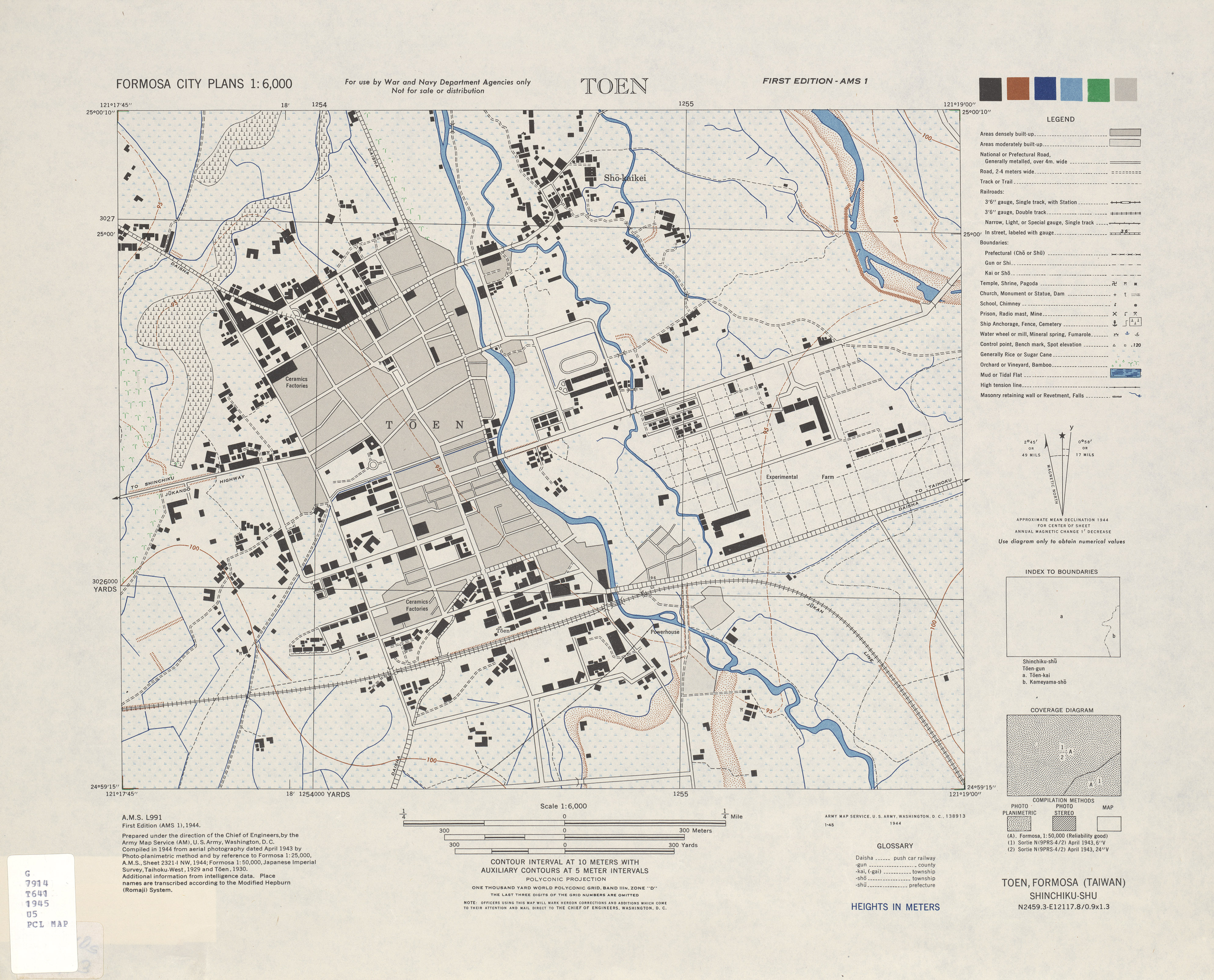
English: Centrl Tōen (later Taoyuan), Formosa (Taiwan) City Plans
中文(臺灣):這批地圖是1944-1945美國海軍航空兵偵照繪製,並配合美國情報相關單位共同標出圖中的地標。 這套圖主要是給美軍轟炸桃園重要官廳、軍事設施用的,所以官廳、地標、軍事設施特別詳細,主要建築物的平面配置形狀都有出現。 |
| Date | between 1944 and 1945 |
| Source | http://www.lib.utexas.edu/maps/ams/formosa_city_plans/ |
| Author | U.S. Army Map Service |
Licensing
[edit]
This work is in the public domain in the United States because it is a work prepared by an officer or employee of the United States Government as part of that person’s official duties under the terms of Title 17, Chapter 1, Section 105 of the US Code.
Note: This only applies to original works of the Federal Government and not to the work of any individual U.S. state, territory, commonwealth, county, municipality, or any other subdivision. This template also does not apply to postage stamp designs published by the United States Postal Service since 1978. (See § 313.6(C)(1) of Compendium of U.S. Copyright Office Practices). It also does not apply to certain US coins; see The US Mint Terms of Use.
|
 | |
| This file has been identified as being free of known restrictions under copyright law, including all related and neighboring rights. | ||
File history
Click on a date/time to view the file as it appeared at that time.
| Date/Time | Thumbnail | Dimensions | User | Comment | |
|---|---|---|---|---|---|
| current | 15:56, 24 March 2011 | | 3,975 × 3,209 (3.05 MB) | Honmingjun (talk | contribs) | {{Information |Description ={{en|1=Centrl Tainan, Formosa (Taiwan) City Plans}} {{zh-tw|1=這批地圖是1944-1945美國海軍航空兵偵照繪製,並配合美國情報相關單位共同標出圖中的地標。 這套圖主要是給美軍轟炸桃� |
You cannot overwrite this file.
File usage on Commons
There are no pages that use this file.