File:Tornado damage La Plata Maryland may 1 2002.jpg

Original file (3,600 × 2,400 pixels, file size: 4 MB, MIME type: image/jpeg)
Captions
Captions
Summary
[edit]| DescriptionTornado damage La Plata Maryland may 1 2002.jpg |
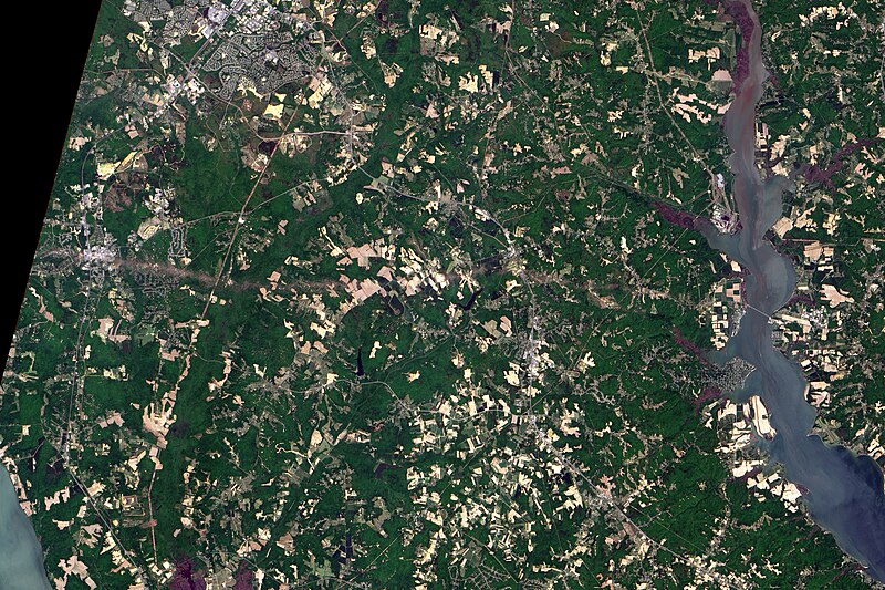
English: A number of severe thunder storms swept through the mid-Atlantic states on April 28, bringing high winds, hailstones, and heavy rains to many areas. The intense storms spawned at least two tornadoes, one of which was classified as an F4 twister. The powerful tornado touched down in southern Maryland and ripped through the town of La Plata, destroying most of the historic downtown. The twister—the strongest ever recorded to hit the state and perhaps the strongest ever recorded in the eastern U.S.—flattened everything in its path along a 39 kilometer (24 mile) swath running west to east through the state.
The tornado’s path can be seen clearly in this pan-sharpened color image acquired on May 1 by the Advanced Land Imager (ALI), flying aboard NASA’s EO-1 satellite. La Plata is situated toward the lefthand side of this scene and the twister’s swath is the bright stripe passing through the town and running eastward 10 kilometers (6 miles) toward the Patuxent River beyond the right-hand side of the image. This stripe is the result of the vegetation flattened by the storm. The flattened vegetation reflects more light than untouched vegetation. EO-1 is the first Earth observing satellite launched as part of NASA’s New Millennium Program. This program is designed to spearhead development and testing of a new generation of satellite remote sensing technologies for future Earth and space science missions. The ALI is designed to improve upon and extend the measurement heritage begun by the Landsat series of satellites well into the 21st Century. |
| Date | |
| Source | http://earthobservatory.nasa.gov/NaturalHazards/view.php?id=9461 |
| Author | NASA Earth Observatory image created by Jesse Allen, using data provided courtesy Lawrence Ong, EO-1 Mission Science Office, NASA GSFC. |
Licensing
[edit]| Public domainPublic domainfalsefalse |
| This file is in the public domain in the United States because it was solely created by NASA. NASA copyright policy states that "NASA material is not protected by copyright unless noted". (See Template:PD-USGov, NASA copyright policy page or JPL Image Use Policy.) |  | |
 |
Warnings:
|
File history
Click on a date/time to view the file as it appeared at that time.
| Date/Time | Thumbnail | Dimensions | User | Comment | |
|---|---|---|---|---|---|
| current | 04:54, 25 November 2010 |  | 3,600 × 2,400 (4 MB) | Supportstorm (talk | contribs) | {{Information |Description={{en|1=A number of severe thunder storms swept through the mid-Atlantic states on April 28, bringing high winds, hailstones, and heavy rains to many areas. The intense storms spawned at least two tornadoes, one of which was clas |
You cannot overwrite this file.
File usage on Commons
There are no pages that use this file.
Metadata
This file contains additional information such as Exif metadata which may have been added by the digital camera, scanner, or software program used to create or digitize it. If the file has been modified from its original state, some details such as the timestamp may not fully reflect those of the original file. The timestamp is only as accurate as the clock in the camera, and it may be completely wrong.
| Image title | IDL TIFF file |
|---|---|
| Width | 3,600 px |
| Height | 2,400 px |
| Compression scheme | LZW |
| Pixel composition | RGB |
| Orientation | Normal |
| Number of components | 4 |
| Horizontal resolution | 100 dpi |
| Vertical resolution | 100 dpi |
| Data arrangement | chunky format |
| Software used | Adobe Photoshop 7.0 |
| File change date and time | 22:40, 24 November 2010 |
| Color space | Uncalibrated |