File:Timucua-And-Surrounding-Groups.png
Jump to navigation
Jump to search

Size of this preview: 750 × 600 pixels. Other resolutions: 300 × 240 pixels | 600 × 480 pixels | 960 × 768 pixels | 1,280 × 1,024 pixels | 2,560 × 2,048 pixels | 6,000 × 4,800 pixels.
Original file (6,000 × 4,800 pixels, file size: 1.65 MB, MIME type: image/png)
Captions
Captions
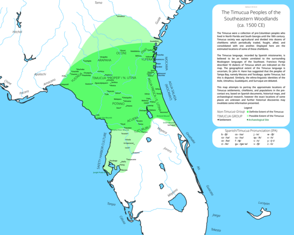
A map of the Timucua and surrounding groups.
Summary
[edit]
| Description |
English: A map of the Timucua peoples and some surrounding groups, including major noted settlements, linguistic divisions, and peoples who may have spoke Timucua |
| Date | |
| Source | Own work |
| Author | KiwiNova |
Licensing
[edit]
I, the copyright holder of this work, hereby publish it under the following license:
This file is licensed under the Creative Commons Attribution-Share Alike 4.0 International license.
- You are free:
- to share – to copy, distribute and transmit the work
- to remix – to adapt the work
- Under the following conditions:
- attribution – You must give appropriate credit, provide a link to the license, and indicate if changes were made. You may do so in any reasonable manner, but not in any way that suggests the licensor endorses you or your use.
- share alike – If you remix, transform, or build upon the material, you must distribute your contributions under the same or compatible license as the original.
File history
Click on a date/time to view the file as it appeared at that time.
| Date/Time | Thumbnail | Dimensions | User | Comment | |
|---|---|---|---|---|---|
| current | 14:28, 15 April 2023 | | 6,000 × 4,800 (1.65 MB) | KiwiNova (talk | contribs) | Improved design (made labels larger for easier viewing and moved information to one box) |
| 01:17, 11 April 2023 |  | 6,000 × 4,800 (1.74 MB) | KiwiNova (talk | contribs) | Fixed visual artifacts and added some more info. | |
| 20:25, 9 April 2023 |  | 6,000 × 4,800 (1.71 MB) | KiwiNova (talk | contribs) | Uploaded own work with UploadWizard |
You cannot overwrite this file.
File usage on Commons
The following page uses this file:
File usage on other wikis
The following other wikis use this file:
- Usage on en.wikipedia.org
Metadata
Categories:
- Maps of Native American tribal territories
- Linguistic maps of Indigenous languages of the United States
- Timucua
- Indigenous peoples of the Southeastern Woodlands
- Native American history of Florida
- History of Florida
- Indigenous peoples of the Americas
- Florida in the 16th century
- Maps showing 16th-century history
- Maps of the history of Georgia (U.S. state)
- Native American history of Georgia (U.S. state)
- Georgia (U.S. state) in the 16th century
- Potano
- Agua Dulce people
- 16th-century Native American history
- Mocoso