File:Taketoyo-IC 1982,1987,2010.jpg
Jump to navigation
Jump to search

Size of this preview: 800 × 408 pixels. Other resolutions: 320 × 163 pixels | 640 × 326 pixels | 1,024 × 522 pixels | 1,951 × 994 pixels.
Original file (1,951 × 994 pixels, file size: 2.35 MB, MIME type: image/jpeg)
Captions
Captions
Add a one-line explanation of what this file represents
Summary
[edit]| Description |
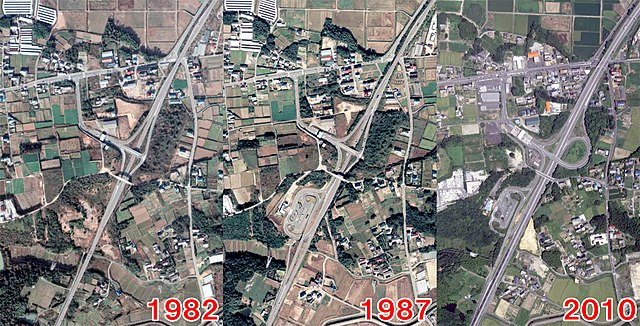
English: Minamichita Road, Taketoyo Interchange. 日本語: 南知多道路 武豊IC |
| Date | / 1987-10-22 / 2010-08-18 |
| Source |
|
| Author |
Licensing
[edit]
|
The copyright holder of this file, Ministry of Land, Infrastructure, Transport and Tourism, allows anyone to use it for any purpose, provided that the copyright holder is properly attributed. Redistribution, derivative work, commercial use, and all other use is permitted. |
Attribution:
National Land Image Information (Color Aerial Photographs), created by Ministry of Land, Infrastructure, Transport and Tourism, distributed by Geospatial Information Authority of Japan
|

File history
Click on a date/time to view the file as it appeared at that time.
| Date/Time | Thumbnail | Dimensions | User | Comment | |
|---|---|---|---|---|---|
| current | 14:25, 2 September 2020 | | 1,951 × 994 (2.35 MB) | ButuCC (talk | contribs) | {{Information |description={{en|1=Minamichita Road, Taketoyo Interchange.}}{{ja|1=南知多道路 武豊IC}} |date=1982-11-27 / 1987-10-22 / 2010-08-18 |source= *国土交通省「国土画像情報(カラー空中写真)」(配布元:国土地理院地図・空中写真閲覧サービス) **[http://mapps.gsi.go.jp/maplibSearch.do?specificationId=834374 CCB824-C13A-4] **[http://mapps.gsi.go.jp/maplibSearch.do?specificationId=854374 CCB874-C12B-4] **[https://mapps.gsi.go.jp/maplibSearch.do?specificationId=1196128 CCB20103-C13-19] |author={{ja|国土地理院、ButuCCが加工... |
You cannot overwrite this file.
File usage on Commons
The following page uses this file:
File usage on other wikis
The following other wikis use this file:
- Usage on ja.wikipedia.org