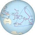
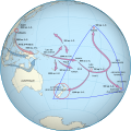
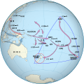
File:Polynesian Migration.svg

Original file (SVG file, nominally 551 × 551 pixels, file size: 625 KB)
Captions
Captions
Summary
[edit]| DescriptionPolynesian Migration.svg |
Català: Una projecció ortogràfica de la Polinèsia
English: An orthographic projection of Polynesia, created from the same data as File:Worldmap_location_NED_50m.svg with gringer's perlshaper script. Inkscape was used to add colour, clip the land, and add migration arrows. |
| Date | |
| Source |
Own work. Dates and arrows are based on Chambers (2008), with additional colouring and styling guided by discussion with Geoff Chambers 2008-2011 as part of my PhD project:
Migration arrows are supported by the following sources:
|
| Author | David Eccles (Gringer (talk)) |
| Permission (Reusing this file) |
Please attribute this work to David Eccles (gringer). This map, created by David Eccles (Rangitāne o Wairau) is based on genetic, archaeological, and radiocarbon dating data and traces the migration routes of the Polynesian population, including the discovery of New Zealand by Māori. An earlier version of the map is included in the introduction of David's [PhD thesis](https://doi.org/10.26686/wgtn.16993075). |
| Other versions |
File:Polynesian Migration.svg has 3 translations.
Other related versions:[edit]
|
| SVG development InfoField |
| This SVG file contains embedded text that can be translated into your language, using any capable SVG editor, text editor or the SVG Translate tool. For more information see: About translating SVG files. |
This file is translated using SVG <switch> elements. All translations are stored in the same file! Learn more.
For most Wikipedia projects, you can embed the file normally (without a To translate the text into your language, you can use the SVG Translate tool. Alternatively, you can download the file to your computer, add your translations using whatever software you're familiar with, and re-upload it with the same name. You will find help in Graphics Lab if you're not sure how to do this. |
Licensing
[edit]- You are free:
- to share – to copy, distribute and transmit the work
- to remix – to adapt the work
- Under the following conditions:
- attribution – You must give appropriate credit, provide a link to the license, and indicate if changes were made. You may do so in any reasonable manner, but not in any way that suggests the licensor endorses you or your use.
File history
Click on a date/time to view the file as it appeared at that time.
| Date/Time | Thumbnail | Dimensions | User | Comment | |
|---|---|---|---|---|---|
| current | 02:09, 15 October 2024 |  | 551 × 551 (625 KB) | NZ 토끼들 (talk | contribs) | File uploaded using svgtranslate tool (https://svgtranslate.toolforge.org/). Added translation for ko. |
| 11:21, 13 October 2024 |  | 551 × 551 (680 KB) | Kiwiz1338 (talk | contribs) | accessibility | |
| 18:18, 8 February 2024 |  | 553 × 553 (664 KB) | Manlleus (talk | contribs) | added catalan language | |
| 18:08, 8 February 2024 |  | 553 × 553 (716 KB) | Manlleus (talk | contribs) | fixed text labels for translation | |
| 17:19, 8 February 2024 |  | 553 × 553 (717 KB) | Manlleus (talk | contribs) | fixed text labels for translation | |
| 17:05, 8 February 2024 |  | 553 × 553 (717 KB) | Manlleus (talk | contribs) | fixed text labels for translation | |
| 05:08, 3 March 2018 |  | 553 × 553 (445 KB) | Gringer (talk | contribs) | Removed "d=" from SVG circle objects to improve validation | |
| 03:20, 2 July 2013 |  | 553 × 553 (510 KB) | Gringer (talk | contribs) | Changed font from Sans/FreeSans to Arial | |
| 03:00, 2 July 2013 |  | 553 × 553 (510 KB) | Gringer (talk | contribs) | Regenerated background image using updated perlshaper script, converted path-like text to proper text, removed "border as another path" oddness that resulted from previous import from my thesis EPS file. | |
| 17:03, 6 March 2012 |  | 542 × 542 (439 KB) | Gringer (talk | contribs) | Updated figure from my thesis |
You cannot overwrite this file.
File usage on Commons
The following 16 pages use this file:
- Polynesia
- Post-classical history
- User:Holly Cheng/Recent uploads/Hawaii/2018 March 3
- User:Holly Cheng/Recent uploads/Hawaii/2024 February 8
- User:Holly Cheng/Recent uploads/Hawaii/2024 October 13
- User:Holly Cheng/Recent uploads/Hawaii/2024 October 15
- User:Magog the Ogre/Multilingual legend/2024 February 5-9
- User:Magog the Ogre/Multilingual legend/2024 October 13-16
- Commons:Graphic Lab/Map workshop/Archive/2020
- File:Early migrations mercator.svg
- File:Map Polynesian migration-fr.svg
- File:Polynesian Migration-id.svg
- File:Polynesian Migration-zh-tw.svg
- File:Polynesian Migration.svg
- File:Polynesian Migration mk.svg
- Template:Other versions/Map Polynesian migration
File usage on other wikis
The following other wikis use this file:
- Usage on af.wikipedia.org
- Usage on ami.wikipedia.org
- Usage on an.wikipedia.org
- Usage on ar.wikipedia.org
- Usage on ban.wikipedia.org
- Usage on ba.wikipedia.org
- Usage on bg.wikipedia.org
- Usage on bjn.wikipedia.org
- Usage on bn.wikipedia.org
- Usage on ca.wikipedia.org
- Usage on cbk-zam.wikipedia.org
- Usage on ckb.wikipedia.org
- Usage on cs.wikipedia.org
- Usage on de.wikipedia.org
- Usage on en.wikipedia.org
- History of New Zealand
- Hawaiki
- Polynesians
- Polynesian culture
- Portal:New Zealand
- User:Gringer
- Portal:Oceania
- Māori migration canoes
- New Zealand
- History of the Otago Region
- Polynesia
- User:OldManRivers/Maori
- Wikipedia:Reference desk/Archives/Humanities/2011 January 30
- Exploration of the Pacific
- Wikipedia:Reference desk/Archives/Humanities/2011 October 17
- User:Liveste/Māori history
- User:Cruickshanks/sandbox5
View more global usage of this file.
Metadata
This file contains additional information such as Exif metadata which may have been added by the digital camera, scanner, or software program used to create or digitize it. If the file has been modified from its original state, some details such as the timestamp may not fully reflect those of the original file. The timestamp is only as accurate as the clock in the camera, and it may be completely wrong.
| Width | 551.25 |
|---|---|
| Height | 551.25 |


