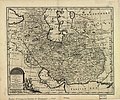
File:Persian(IRAN) Empire 1747.jpg

Original file (5,420 × 4,548 pixels, file size: 8.38 MB, MIME type: image/jpeg)
Captions
Captions
Summary
[edit]| DescriptionPersian(IRAN) Empire 1747.jpg |
English: The map of the Persian Empire in 1747 at the time of Afsharid Dynasty. a complete system of geography.
فارسی: نقشهٔ امپراطوری ایران در سال ۱۷۴۷ میلادی برابر با ۱۱۲۶ خورشیدی و ۱۱۶۰ قمری در زمان دودمان افشاریان |
|||||||||||||||||||||||
| Date |
circa 1750 date QS:P,+1750-00-00T00:00:00Z/9,P1480,Q5727902 |
|||||||||||||||||||||||
| Source | http://memory.loc.gov/ | |||||||||||||||||||||||
| Author |
creator QS:P170,Q330967 |
|||||||||||||||||||||||
| Other versions |
Derivative works of this file: |
|||||||||||||||||||||||
|
Licensing
[edit]|
This is a faithful photographic reproduction of a two-dimensional, public domain work of art. The work of art itself is in the public domain for the following reason:
The official position taken by the Wikimedia Foundation is that "faithful reproductions of two-dimensional public domain works of art are public domain".
This photographic reproduction is therefore also considered to be in the public domain in the United States. In other jurisdictions, re-use of this content may be restricted; see Reuse of PD-Art photographs for details. | |||||
File history
Click on a date/time to view the file as it appeared at that time.
| Date/Time | Thumbnail | Dimensions | User | Comment | |
|---|---|---|---|---|---|
| current | 18:21, 9 July 2012 |  | 5,420 × 4,548 (8.38 MB) | Paris 16 (talk | contribs) | e |
| 15:40, 31 August 2008 |  | 5,664 × 4,715 (7.22 MB) | Wayiran (talk | contribs) | {{Information |Description={{en|1=The map of the Persian Empire in 1747 at the time of Afsharid Dynasty}} {{fa|1=نقشهٔ امپراطوری ایران در سال ۱۷۴۷ میلادی برابر با ۱۱۲۶ خورشیدی و ۱۱۶۰ قمری در � |
You cannot overwrite this file.
File usage on Commons
The following 7 pages use this file:
- Commons:Featured picture candidates/File:Persian(IRAN) Empire 1747.jpg
- Commons:Featured picture candidates/Log/July 2012
- File:Aras River in Persian (IRAN) Empire 1747 map.JPG
- File:Caspian sea in Persian (IRAN) Empire 1747.JPG
- File:Persian(IRAN) Empire 1747 (A).JPG
- File:Persian(IRAN) Empire 1747 (B).JPG
- File:گیلان در نقشه امپراطوری افشاریه سال 1747 میادی.jpg
File usage on other wikis
The following other wikis use this file:
- Usage on azb.wikipedia.org
- Usage on az.wikipedia.org
- Usage on ckb.wikipedia.org
- Usage on de.wikipedia.org
- Usage on diq.wikipedia.org
- Usage on en.wikipedia.org
- Usage on eo.wikipedia.org
- Usage on et.wikipedia.org
- Usage on fa.wikipedia.org
- دریای عمان
- خلیج فارس
- مشهد
- تاریخ ایران
- نادرشاه
- شهرستان میانه
- میانه (آذربایجان شرقی)
- ایران بزرگ
- ایران افشاری
- کازرون
- نقشهنگاری
- تاریخ ارمنستان
- تحریف نام خلیج فارس
- جغرافیای تاریخی ایران
- ویکیپدیا:گزیدن نگاره برگزیده/دسامبر-۲۰۱۱
- ویکیپدیا:نگارههای برگزیده/نقشه
- ویکیپدیا:نگاره روز/آوریل ۲۰۱۲
- نقشه ایران در دوره افشاریه
- ویکیپدیا:گزیدن نگاره برگزیده/Persian(IRAN) Empire 1747.jpg
- الگو:نر/2012-04-06
- بحث کاربر:Alborzagros/بایگانی ۴
- الگو:نر محافظت شده/2012-04-06
- نقشههای کهن
- ارمنستان ایران (۱۵۰۲–۱۸۲۸)
- فهرست سلسلههای ایران
- بحث:آذربایجان/بایگانی ۲
- Usage on fa.wikibooks.org
- Usage on fr.wikipedia.org
- Usage on hi.wikipedia.org
View more global usage of this file.
Metadata
This file contains additional information such as Exif metadata which may have been added by the digital camera, scanner, or software program used to create or digitize it. If the file has been modified from its original state, some details such as the timestamp may not fully reflect those of the original file. The timestamp is only as accurate as the clock in the camera, and it may be completely wrong.
| Orientation | Normal |
|---|---|
| Horizontal resolution | 72 dpi |
| Vertical resolution | 72 dpi |
| Software used | ACD Systems Digital Imaging |
| File change date and time | 20:46, 31 August 2008 |
| Exif version | 2.2 |
| DateTime subseconds | 796 |
