File:Paris Metro Ligne 2.svg
Jump to navigation
Jump to search

Size of this PNG preview of this SVG file: 800 × 358 pixels. Other resolutions: 320 × 143 pixels | 640 × 286 pixels | 1,024 × 458 pixels | 1,280 × 572 pixels | 2,560 × 1,144 pixels | 850 × 380 pixels.
Original file (SVG file, nominally 850 × 380 pixels, file size: 30 KB)
Captions
Captions
Add a one-line explanation of what this file represents
Summary
[edit]| Description |
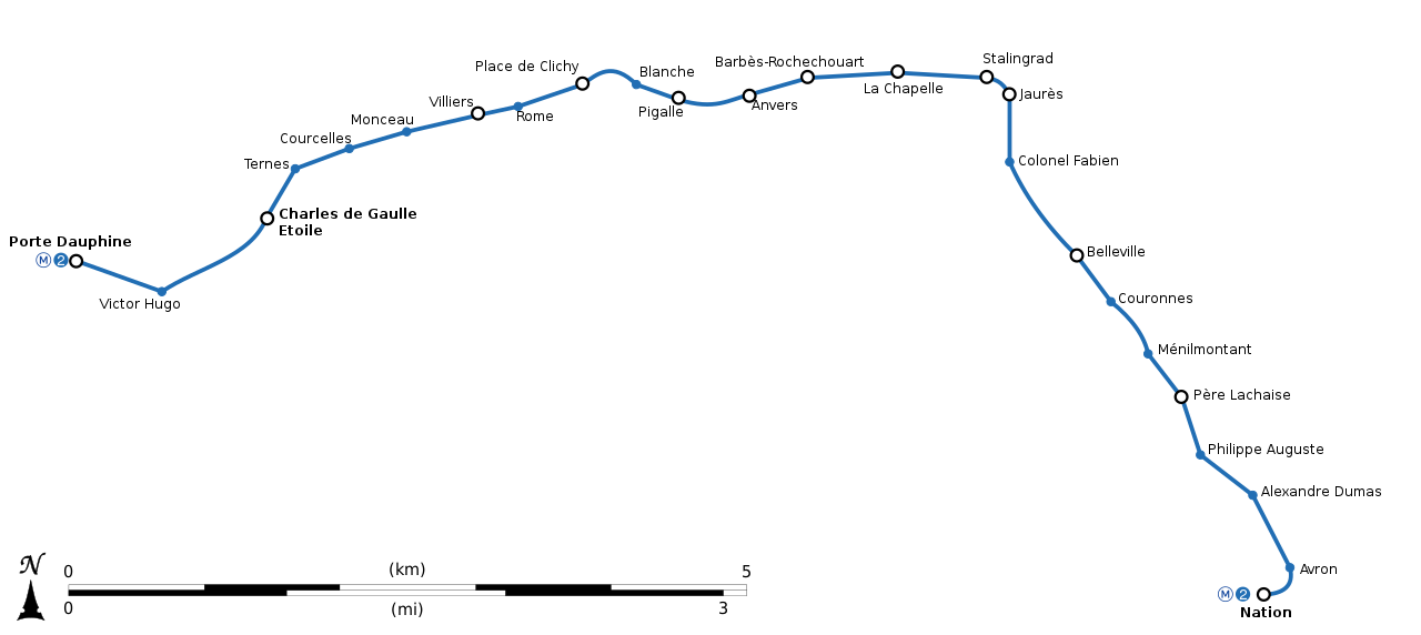
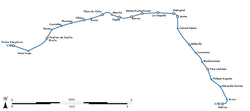
English: Geographically accurate path of Paris Métro Line 2. Français : Plan géographique de la ligne 2 du métro de Paris. |
||
| Date | (UTC) | ||
| Source | File:Paris-m2m6.svg by Controlling under licence CC0 | ||
| Author | Sémhur (talk) | ||
| Other versions | |||
| SVG |
|
||
| Graphic Lab |

| Object location | | View this and other nearby images on: OpenStreetMap |
|---|
Licensing
[edit]
I, the copyright holder of this work, hereby publish it under the following license:
| This file is made available under the Creative Commons CC0 1.0 Universal Public Domain Dedication. | |
| The person who associated a work with this deed has dedicated the work to the public domain by waiving all of their rights to the work worldwide under copyright law, including all related and neighboring rights, to the extent allowed by law. You can copy, modify, distribute and perform the work, even for commercial purposes, all without asking permission.
|
File history
Click on a date/time to view the file as it appeared at that time.
| Date/Time | Thumbnail | Dimensions | User | Comment | |
|---|---|---|---|---|---|
| current | 23:24, 12 October 2018 | | 850 × 380 (30 KB) | AlexBurn44 (talk | contribs) | corres |
| 16:33, 13 March 2015 |  | 850 × 380 (30 KB) | Sémhur (talk | contribs) | + échelle ou pictogramme de la ligne | |
| 12:59, 23 February 2015 |  | 850 × 380 (18 KB) | Sémhur (talk | contribs) | == {{int:filedesc}} == {{Information |Description={{Multilingual description |en= Geographically accurate path of Paris Métro Line 2. |fr= Plan géographique de la [[:fr:ligne 2 du métro de Paris|ligne 2 du métro de Paris... |
You cannot overwrite this file.
File usage on Commons
The following 15 pages use this file:
- List of Paris Metro lines
- Maps of Paris
- Paris Metro
- User:Chumwa/OgreBot/Potential transport maps/2018 October 11-20
- User:Chumwa/OgreBot/Public transport information/2015 February 19-28
- User:Chumwa/OgreBot/Public transport information/2015 March 11-20
- User:Chumwa/OgreBot/Public transport information/2018 October 11-20
- User:Chumwa/OgreBot/Transport Maps/2015 February 19-28
- User:Chumwa/OgreBot/Transport Maps/2015 March 11-20
- User:Chumwa/OgreBot/Transport Maps/2018 October 11-20
- User:Chumwa/OgreBot/Travel and communication maps/2018 October 11-20
- User:Hoff1980/Rail transport in France/2015 February 19-28
- User:Hoff1980/Rail transport in France/2015 March 11-20
- User:Liesel/Rail transport/2015 February 19-28
- File:Ligne 2.gif
File usage on other wikis
The following other wikis use this file:
- Usage on bs.wikipedia.org
- Usage on cs.wikipedia.org
- Usage on dsb.wikipedia.org
- Usage on en.wikipedia.org
- Usage on eo.wikipedia.org
- Usage on fi.wikipedia.org
- Usage on fr.wikipedia.org
- Usage on id.wikipedia.org
- Usage on it.wikipedia.org
- Usage on ja.wikipedia.org
- Usage on ko.wikipedia.org
- Usage on lb.wikipedia.org
- Usage on nl.wikipedia.org
- Usage on no.wikipedia.org
- Usage on oc.wikipedia.org
- Usage on pl.wikipedia.org
- Usage on ru.wikipedia.org
- Usage on sk.wikipedia.org
- Usage on www.wikidata.org