File:Palace and Gardens of Schönbrunn rough map 2008.gif

Original file (780 × 840 pixels, file size: 27 KB, MIME type: image/gif)
Captions
Captions
Note:
Please do not yet convert thisone to svg, as it still might contain an error. [w.] 09:30, 13 January 2009 (UTC)
| Description |
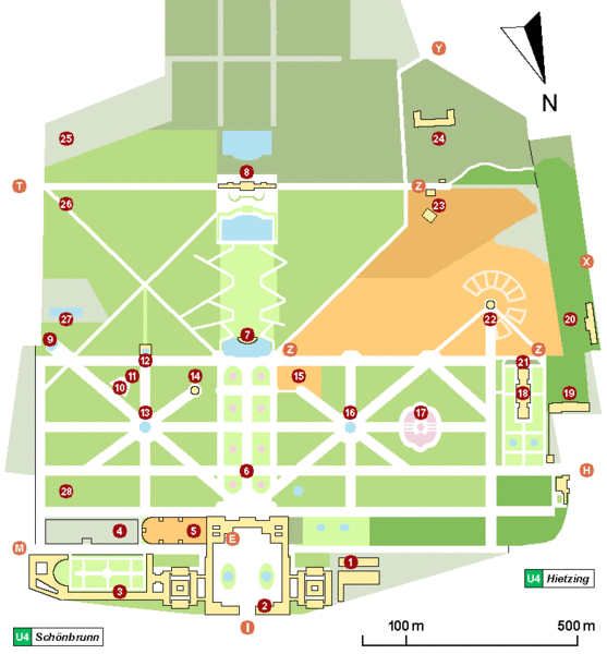
Schönbrunn (Vienna) palace and gardens map As of now, the characters and numbers mean the following:
(1) - 'Wagenburg', ehemalige Winterreitschule, jetzt Museum für Kutschen - 'Wagenburg', a carriage museum. (9) - Obeliskbrunnen - Obelisk Fountain. (22) - Zoo und 'Kaiserpavillion' - world's eldest existing zoo, with 'Emperor's pavilion' (now a Café). (23) - 'Tirolerhaus' und 'Tiroler Garten', now part of the zoo. 'Tirolerhaus' restaurant is outside the zoo. Side entrance to zoo (open temporarily). (24) - Bundesforschungs- und Ausbildungszentrum für Wald, Naturgefahren und Landschaft (BFW) - Federal Research and Training Centre for Forests, Natural Hazards and Landscape - formerly Forstliche Bundes-Versuchsanstalt (FBVA) (25) - Höhere Bundeslehr- und Versuchsanstalt für Gartenbau (26) - 'Kleine Gloriette' - 'Little Gloriette' (27) - 'Schönbrunner Bad' (a public swimming pool). (28) - 'Meierei', now a restaurant. |
| Date | |
| Source | Own work |
| Author | Wolfgang H. Wögerer, Wien |
| Permission (Reusing this file) |
I, the copyright holder of this work, hereby publish it under the following license: This file is licensed under the Creative Commons Attribution-Share Alike 3.0 Unported license.
|
| Annotations | This image is annotated: View the annotations at Commons |


File history
Click on a date/time to view the file as it appeared at that time.
| Date/Time | Thumbnail | Dimensions | User | Comment | |
|---|---|---|---|---|---|
| current | 14:05, 20 March 2008 | | 780 × 840 (27 KB) | W. (talk | contribs) | |
| 19:00, 27 February 2008 |  | 780 × 840 (25 KB) | W. (talk | contribs) | ||
| 14:59, 26 February 2008 |  | 780 × 820 (25 KB) | W. (talk | contribs) | ||
| 17:17, 19 February 2008 |  | 800 × 850 (23 KB) | W. (talk | contribs) | {{Information= Schönbrunn (Vienna) palace and gardens rough map. This map tries to show buildings of major public interest, monuments, garden partions, alleys and the main entrances used by visitors. It was created by trying to merge officially available |
You cannot overwrite this file.
File usage on Commons
The following 4 pages use this file:
_2008.jpg)
_Nymphe_Egeria_20080224.jpg)
File usage on other wikis
The following other wikis use this file:
- Usage on de.wikipedia.org
- Usage on de.wikiversity.org
- Usage on de.wikivoyage.org
- Usage on en.wikipedia.org
- Usage on fa.wikipedia.org
- Usage on fr.wikipedia.org
- Usage on hr.wikipedia.org
- Usage on hu.wikipedia.org
- Usage on it.wikipedia.org
- Usage on ja.wikipedia.org
- Usage on mk.wikipedia.org
- Usage on mt.wikipedia.org
- Usage on pa.wikipedia.org
- Usage on ru.wikipedia.org
- Usage on sh.wikipedia.org
- Usage on sv.wikipedia.org
- Usage on th.wikipedia.org
- Usage on vi.wikipedia.org