File:Operation Pamphlet 24 Jan - 27 Feb 1943.svg
Jump to navigation
Jump to search

Size of this PNG preview of this SVG file: 637 × 599 pixels. Other resolutions: 255 × 240 pixels | 510 × 480 pixels | 817 × 768 pixels | 1,089 × 1,024 pixels | 2,178 × 2,048 pixels | 1,075 × 1,011 pixels.
Original file (SVG file, nominally 1,075 × 1,011 pixels, file size: 61 KB)
Captions
Captions
Add a one-line explanation of what this file represents
Summary
[edit]
| Description |
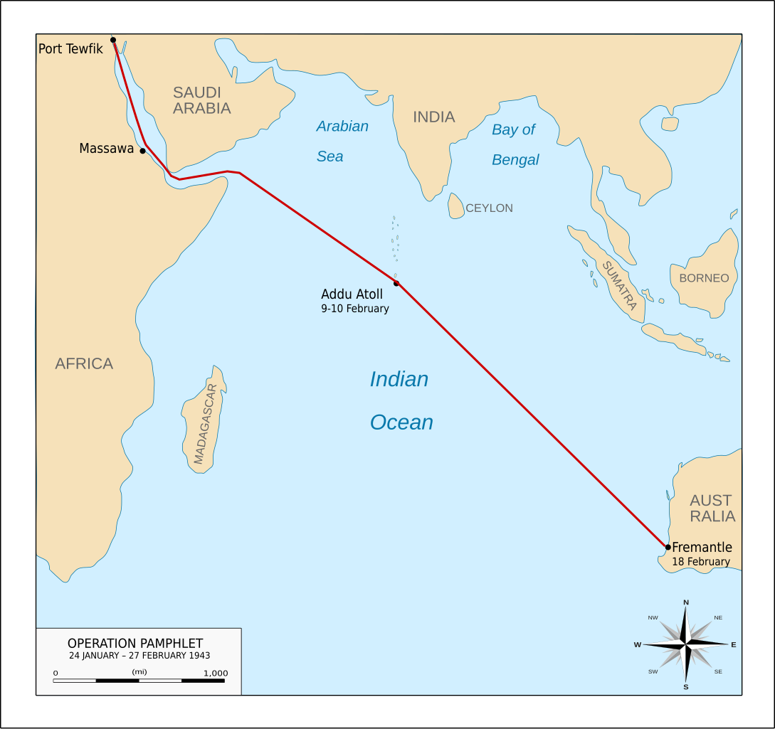
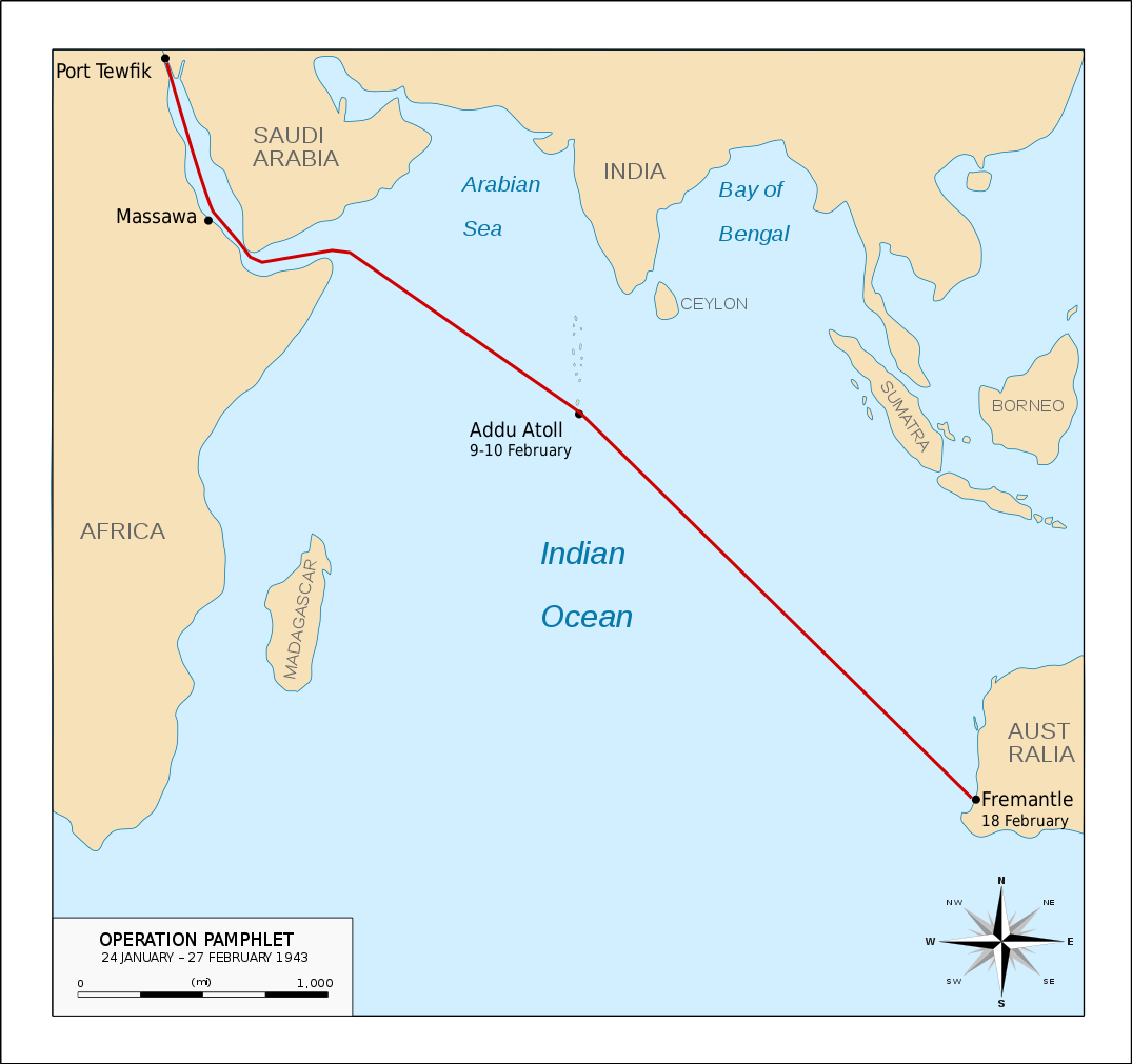
English: Map illustrating en:Operation Pamphlet, which took place 24 January – 27 February 1943. The map is based on that published in Faulkner, Marcus; Wilkinson, Peter (2012). War at Sea: A Naval Atlas, 1939–1945. Annapolis, Maryland: Naval Institute Press. ISBN 9781591145608. Page 168. |
| Date | |
| Source | Own work |
| Author | Anotherclown |
Licensing
[edit]
Anotherclown at English Wikipedia, the copyright holder of this work, hereby publishes it under the following license:
This file is licensed under the Creative Commons Attribution-Share Alike 3.0 Unported license.
Attribution: Anotherclown at English Wikipedia
- You are free:
- to share – to copy, distribute and transmit the work
- to remix – to adapt the work
- Under the following conditions:
- attribution – You must give appropriate credit, provide a link to the license, and indicate if changes were made. You may do so in any reasonable manner, but not in any way that suggests the licensor endorses you or your use.
- share alike – If you remix, transform, or build upon the material, you must distribute your contributions under the same or compatible license as the original.
File history
Click on a date/time to view the file as it appeared at that time.
| Date/Time | Thumbnail | Dimensions | User | Comment | |
|---|---|---|---|---|---|
| current | 04:52, 23 October 2016 | | 1,075 × 1,011 (61 KB) | Anotherclown (talk | contribs) | Try to fix scale issue with Malvdives, add some continent / place names for context |
| 22:34, 31 August 2016 |  | 1,075 × 1,011 (55 KB) | Nick-D (talk | contribs) | Thicker route line - thanks to AC for instructions! | |
| 10:32, 31 August 2016 |  | 1,075 × 1,011 (55 KB) | Nick-D (talk | contribs) | Fix error | |
| 10:31, 31 August 2016 |  | 1,075 × 1,011 (56 KB) | Nick-D (talk | contribs) | Added the route the convoy took | |
| 06:20, 31 August 2016 |  | 1,075 × 1,011 (54 KB) | Anotherclown (talk | contribs) | Added location of ports etc. used during convoy, some corrections to coast line, add Suez Canal | |
| 21:52, 29 August 2016 |  | 1,075 × 1,011 (43 KB) | Anotherclown (talk | contribs) | == {{int:filedesc}} == {{Information |Description={{en|Map illustrating en:Operation Pamphlet, which took place 24 January – 27 February 1943.}} |Source=Self created |Date=30 August 2016 |Author=Anotherclown |Permission... |
You cannot overwrite this file.
File usage on Commons
The following 2 pages use this file:
File usage on other wikis
The following other wikis use this file:
- Usage on br.wikipedia.org
- Usage on en.wikipedia.org