File:Oakburn and Bos400 map.png
Jump to navigation
Jump to search

Size of this preview: 800 × 590 pixels. Other resolutions: 320 × 236 pixels | 640 × 472 pixels | 1,024 × 755 pixels | 1,280 × 944 pixels | 2,560 × 1,888 pixels | 9,565 × 7,053 pixels.
Original file (9,565 × 7,053 pixels, file size: 3.83 MB, MIME type: image/png)
Captions
Captions
Add a one-line explanation of what this file represents
Summary
[edit]
| Description |
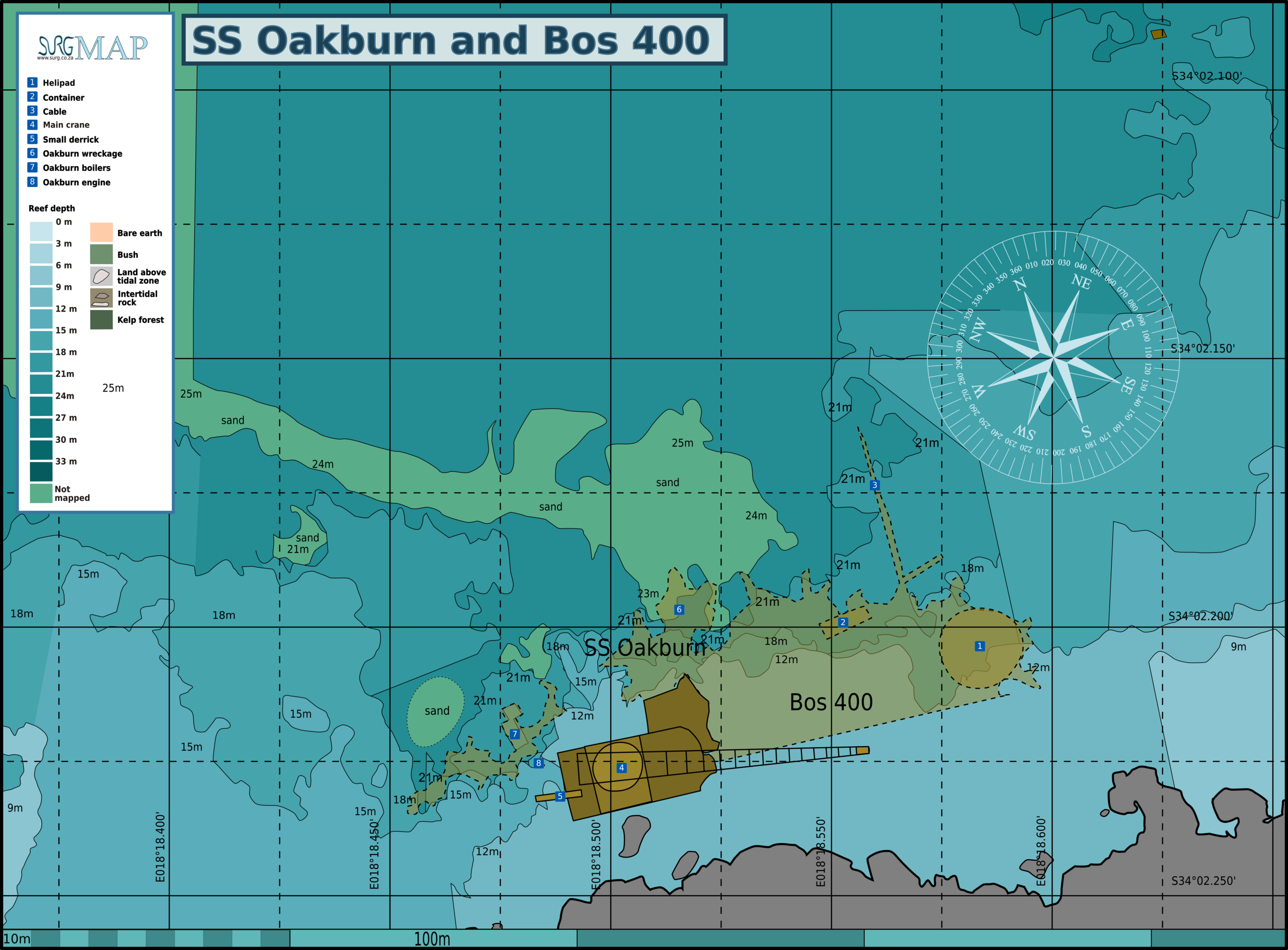
English: Map of the dive sites SS Oakburn and the Bos 400, Cape Peninsula. |
| Date | |
| Source | Peter Southwood |
| Author | Peter Southwood |
Licensing
[edit]
User: (WT-shared) Pbsouthwood at wts wikivoyage, the copyright holder of this work, hereby publishes it under the following license:
This file is licensed under the Creative Commons Attribution-Share Alike 3.0 Unported license.
Attribution: User: (WT-shared) Pbsouthwood at wts wikivoyage
- You are free:
- to share – to copy, distribute and transmit the work
- to remix – to adapt the work
- Under the following conditions:
- attribution – You must give appropriate credit, provide a link to the license, and indicate if changes were made. You may do so in any reasonable manner, but not in any way that suggests the licensor endorses you or your use.
- share alike – If you remix, transform, or build upon the material, you must distribute your contributions under the same or compatible license as the original.
Original upload log
[edit]
| This file was imported from Wikivoyage WTS. |
The original description page was here. All following user names refer to wts.wikivoyage-old.
org:
- 2012-01-01 08:53 (WT-shared) Pbsouthwood[dead link] 3000×2492 (668388 bytes) {{Imagecredit|credit=Peter Southwood|captureDate=January 2012|location=Cape Peninsula|source=Peter Southwood|caption=Map of the dive sites S (Import from wikitravel.org/shared)
- 2012-09-07 19:28 Pbsouthwood[dead link] 3000×2492 (686568 bytes) rm logo
File history
Click on a date/time to view the file as it appeared at that time.
| Date/Time | Thumbnail | Dimensions | User | Comment | |
|---|---|---|---|---|---|
| current | 12:32, 31 March 2024 | | 9,565 × 7,053 (3.83 MB) | Pbsouthwood (talk | contribs) | more 18 and 21m contour |
| 14:34, 4 January 2024 |  | 9,565 × 7,053 (3.81 MB) | Pbsouthwood (talk | contribs) | more sand patch and 21m contour | |
| 19:05, 16 December 2023 |  | 9,565 × 7,053 (3.66 MB) | Pbsouthwood (talk | contribs) | More 21m contour | |
| 11:12, 28 February 2022 |  | 9,565 × 7,053 (3.47 MB) | Pbsouthwood (talk | contribs) | add sand edge and some partial contours | |
| 08:39, 10 January 2017 |  | 9,119 × 6,724 (2.79 MB) | Pbsouthwood (talk | contribs) | Added 12 and 15m contour sections | |
| 13:59, 27 January 2013 |  | 3,000 × 2,285 (765 KB) | Pbsouthwood (talk | contribs) | Add more of Oakburn debris field and 18m contour, label Oakburn boilers | |
| 16:11, 23 December 2012 |  | 3,000 × 2,492 (670 KB) | OgreBot (talk | contribs) | (BOT): Reverting to most recent version before archival | |
| 16:11, 23 December 2012 |  | 3,000 × 2,492 (653 KB) | OgreBot (talk | contribs) | (BOT): Uploading old version of file from wts.wikivoyage; originally uploaded on 2012-01-01 08:53:33 by (WT-shared) Pbsouthwood | |
| 19:23, 15 November 2012 |  | 3,000 × 2,492 (670 KB) | MGA73bot2 (talk | contribs) | {{BotMoveToCommons|wts.oldwikivoyage|year={{subst:CURRENTYEAR}}|month={{subst:CURRENTMONTHNAME}}|day={{subst:CURRENTDAY}}}} == {{int:filedesc}} == {{Information |description=Map of the dive sites SS Oakburn and the Bos 400. , Cape Peninsula |date=Janua... |
You cannot overwrite this file.
File usage on Commons
The following 11 pages use this file:
- User:Chumwa/OgreBot/Transport Maps/2022 February 19-28
- User:Chumwa/OgreBot/Transport Maps/2023 December 11-20
- User:Chumwa/OgreBot/Transport Maps/2024 January 1-10
- User:Chumwa/OgreBot/Transport Maps/2024 March 21-31
- User:Chumwa/OgreBot/Travel and communication maps/2017 January 1-10
- User:Chumwa/OgreBot/Travel and communication maps/2022 February 19-28
- User:Chumwa/OgreBot/Travel and communication maps/2023 December 11-20
- User:Chumwa/OgreBot/Travel and communication maps/2024 January 1-10
- User:Chumwa/OgreBot/Travel and communication maps/2024 March 21-31
- User:OgreBot/Watercraft/2017 January 10
- Category:Bos 400 (ship, 1984)
File usage on other wikis
The following other wikis use this file:
- Usage on en.wikivoyage.org
- Usage on www.wikidata.org