File:Near East ancient map.jpg
Jump to navigation
Jump to search
No higher resolution available.
Near_East_ancient_map.jpg (638 × 415 pixels, file size: 377 KB, MIME type: image/jpeg)
Captions
Captions
Add a one-line explanation of what this file represents
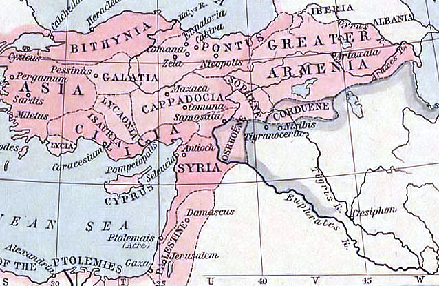
| Description | The Growth of Roman Power in Asia Minor III (As organized by Pompey 63 BC)[1] |
| Date | |
| Source | "Historical Atlas" by William R. Shepherd, New York, Henry Holt and Company |
| Author | Willian Shepherd (1871-1934)[2] |
![[1]](http://www.lib.utexas.edu/maps/historical/shepherd/asia_minor_roman_power.jpg)
|
This work is in the public domain in its country of origin and other countries and areas where the copyright term is the author's life plus 70 years or fewer. | |
| This file has been identified as being free of known restrictions under copyright law, including all related and neighboring rights. | |
| date/time | username | edit summary |
|---|---|---|
| 10:13, 30 July 2007 | heja_helweda | ("Historical Atlas" by William R. Shepherd, New York, Henry Holt and Company, 1923 PUBLIC DOMAIN) |
File history
Click on a date/time to view the file as it appeared at that time.
| Date/Time | Thumbnail | Dimensions | User | Comment | |
|---|---|---|---|---|---|
| current | 12:42, 2 May 2015 | | 638 × 415 (377 KB) | Themadchopper (talk | contribs) | readability |
| 15:08, 27 May 2006 |  | 638 × 415 (69 KB) | Tirigan~commonswiki (talk | contribs) | Kurdish Kingdom of Corduene and Sophene |
You cannot overwrite this file.
File usage on Commons
The following 2 pages use this file:
- Atlas of Kurdistan
- File:Kurdish Kingdoms of Corduene-Sophene.jpg (file redirect)
File usage on other wikis
The following other wikis use this file:
- Usage on ar.wikipedia.org
- Usage on az.wikipedia.org
- Usage on ba.wikipedia.org
- Usage on ca.wikipedia.org
- Usage on ckb.wikipedia.org
- Usage on cy.wikipedia.org
- Usage on de.wikipedia.org
- Usage on el.wikipedia.org
- Usage on en.wikipedia.org
- Usage on es.wikipedia.org
- Usage on fa.wikipedia.org
- Usage on fr.wikipedia.org
- Usage on hu.wikipedia.org
- Usage on id.wikipedia.org
- Usage on it.wikipedia.org
- Usage on ja.wikipedia.org
- Usage on ka.wikipedia.org
- Usage on ku.wikipedia.org
- Usage on pnb.wikipedia.org
- Usage on pt.wikipedia.org
- Usage on ru.wikipedia.org
- Usage on sl.wikipedia.org
- Usage on sr.wikipedia.org
- Usage on sv.wikipedia.org
- Usage on tr.wikipedia.org
View more global usage of this file.