File:NPS colorado-national-monument-geologic-map.jpg
Jump to navigation
Jump to search

Size of this preview: 800 × 565 pixels. Other resolutions: 320 × 226 pixels | 640 × 452 pixels | 1,024 × 723 pixels | 1,280 × 904 pixels | 2,560 × 1,807 pixels | 3,839 × 2,710 pixels.
Original file (3,839 × 2,710 pixels, file size: 1.9 MB, MIME type: image/jpeg)
Captions
Captions
Add a one-line explanation of what this file represents
Summary
[edit]
| Description |
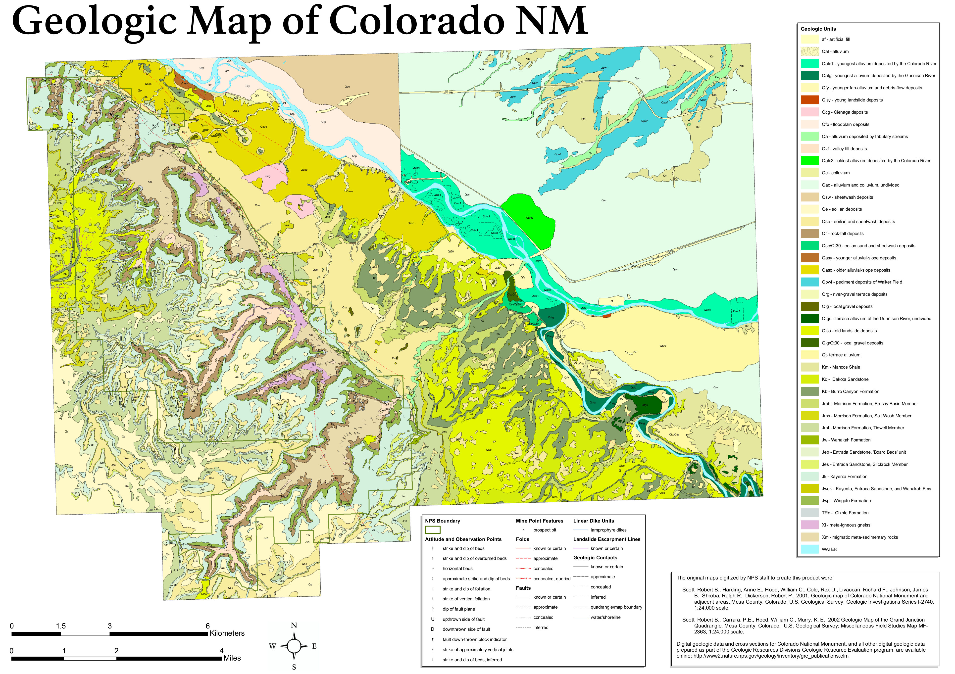
English: The Colorado National Monument geologic map labels the various rock types you’ll find in the park, many of which you’ll see repeated in nearby parks such as Arches and Canyonlands in Utah. |
| Date | |
| Source | U.S. National Park Service (http://npmaps.com/wp-content/uploads/colorado-national-monument-geologic-map.jpg) |
| Author | U.S. National Park Service, restoration/cleanup by Matt Holly |
Licensing
[edit]
| This image or media file contains material based on a work of a National Park Service employee, created as part of that person's official duties. As a work of the U.S. federal government, such work is in the public domain in the United States. See the NPS website and NPS copyright policy for more information. |
File history
Click on a date/time to view the file as it appeared at that time.
| Date/Time | Thumbnail | Dimensions | User | Comment | |
|---|---|---|---|---|---|
| current | 20:08, 16 May 2017 | | 3,839 × 2,710 (1.9 MB) | RKBot (talk | contribs) | =={{int:filedesc}}== {{Information |description= {{en|1=The Colorado National Monument geologic map labels the various rock types you’ll find in the park, many of which you’ll see repeated in nearby parks such as Arches and Canyonlands in Utah.}} |... |
You cannot overwrite this file.
File usage on Commons
The following page uses this file:
Categories:
- Maps of Colorado National Monument
- Geological maps of Colorado
- Quaternary alluvium in Colorado
- Quaternary landslide deposits in Colorado
- Quaternary Ciénaga deposits in Colorado
- Quaternary floodplain deposits in Colorado
- Quaternary colluvium in Colorado
- Quaternary aeolian deposits in Colorado
- Quaternary rockfall deposits in Colorado
- Quaternary gravels in Colorado
- Mancos Shale maps
- Dakota Sandstone in Colorado
- Dakota Formation - maps
- Burro Canyon Formation
- Brushy Basin Member
- Salt Wash Member, Morrison Formation
- Tidwell Member (Morrison Formation)
- Morrison Formation maps
- Wanakah Formation
- Board Beds Unit, Entrada Sandstone
- Slickrock Member, Entrada Sandstone
- Entrada Sandstone maps
- Kayenta Formation in Colorado
- Kayenta Formation - maps
- Wingate Sandstone in Colorado
- Wingate Sandstone maps
- Chinle Formation in Colorado
- Chinle Formation maps
- Proterozoic metamorphic rocks in Colorado
- Entrada Sandstone in Colorado