File:NL - locator map municipality code GM0983 (2016).png
Jump to navigation
Jump to search

Size of this preview: 800 × 533 pixels. Other resolutions: 320 × 213 pixels | 640 × 427 pixels | 1,024 × 683 pixels | 1,280 × 854 pixels | 2,125 × 1,417 pixels.
Original file (2,125 × 1,417 pixels, file size: 368 KB, MIME type: image/png)
Captions
Captions
Add a one-line explanation of what this file represents
Summary
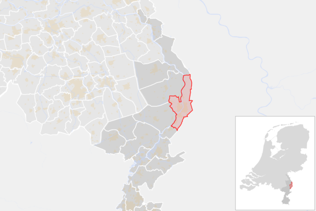
[edit]| Description | Locator map showing municipality boundary of one of the 390 Dutch municipalities (as of 2016) | |||
| Date | ||||
| Source | own work using free available sources | |||
| Author |
Michiel1972 using data from CBS.
|
|||
| Permission (Reusing this file) |
Attribution ShareAlike 3.0 |

.png&action=edit§ion=1)
Licensing
[edit].png&action=edit§ion=2)
This file is licensed under the Creative Commons Attribution-Share Alike 3.0 Unported license.
- You are free:
- to share – to copy, distribute and transmit the work
- to remix – to adapt the work
- Under the following conditions:
- attribution – You must give appropriate credit, provide a link to the license, and indicate if changes were made. You may do so in any reasonable manner, but not in any way that suggests the licensor endorses you or your use.
- share alike – If you remix, transform, or build upon the material, you must distribute your contributions under the same or compatible license as the original.
File history
Click on a date/time to view the file as it appeared at that time.
| Date/Time | Thumbnail | Dimensions | User | Comment | |
|---|---|---|---|---|---|
| current | 20:45, 29 February 2016 | | 2,125 × 1,417 (368 KB) | Michiel1972 (talk | contribs) |
You cannot overwrite this file.
File usage on Commons
The following 37 pages use this file:
- Venlo
- User:Michiel1972/gallery
- Category:Aerial photographs of Venlo
- Category:Architecture in Venlo
- Category:Aviation in Venlo
- Category:Bakeries in Venlo
- Category:Births in Venlo
- Category:Bridges in Venlo
- Category:Buildings in Venlo
- Category:Carnival in Venlo
- Category:City gates in Venlo
- Category:Construction in Venlo
- Category:Districs of Venlo
- Category:Factories in Venlo
- Category:Farms in Venlo
- Category:Ferries around Venlo
- Category:Firefighting in Venlo
- Category:Horeca in Venlo
- Category:Hospitals in Venlo
- Category:Industry of Venlo
- Category:Maps of Venlo
- Category:Media about Venlo
- Category:Media in Venlo
- Category:Meuse River in Venlo
- Category:Military buildings in Venlo
- Category:Old maps of Venlo
- Category:People of Venlo
- Category:Petrol stations in Venlo
- Category:Police in Venlo
- Category:Pontoon bridges around Venlo
- Category:Postcards of Venlo
- Category:Public services in Venlo
- Category:Sieges of Venlo
- Category:Sports in Venlo
- Category:Urban planning in Venlo
- Category:Venlo
- Category:Venlo in the news
File usage on other wikis
The following other wikis use this file:
- Usage on ar.wikipedia.org
- Usage on arz.wikipedia.org
- Usage on ca.wikipedia.org
- Usage on ceb.wikipedia.org
- Usage on el.wikipedia.org
- Usage on eo.wikipedia.org
- Usage on eu.wikipedia.org
- Usage on la.wikipedia.org
- Usage on lb.wikipedia.org
- Usage on li.wikipedia.org
- Usage on nl.wikipedia.org
- Usage on pt.wikipedia.org
- Usage on ru.wikipedia.org
- Usage on vo.wikipedia.org
- Usage on www.wikidata.org
.png&oldid=723466987)