File:Mont de Mastle Gherdëina.JPG
Jump to navigation
Jump to search

Size of this preview: 800 × 531 pixels. Other resolutions: 320 × 213 pixels | 640 × 425 pixels | 1,024 × 680 pixels | 1,280 × 850 pixels | 2,560 × 1,700 pixels | 4,288 × 2,848 pixels.
Original file (4,288 × 2,848 pixels, file size: 6.45 MB, MIME type: image/jpeg)
Captions
Captions
Add a one-line explanation of what this file represents
Summary
[edit]
| Description |
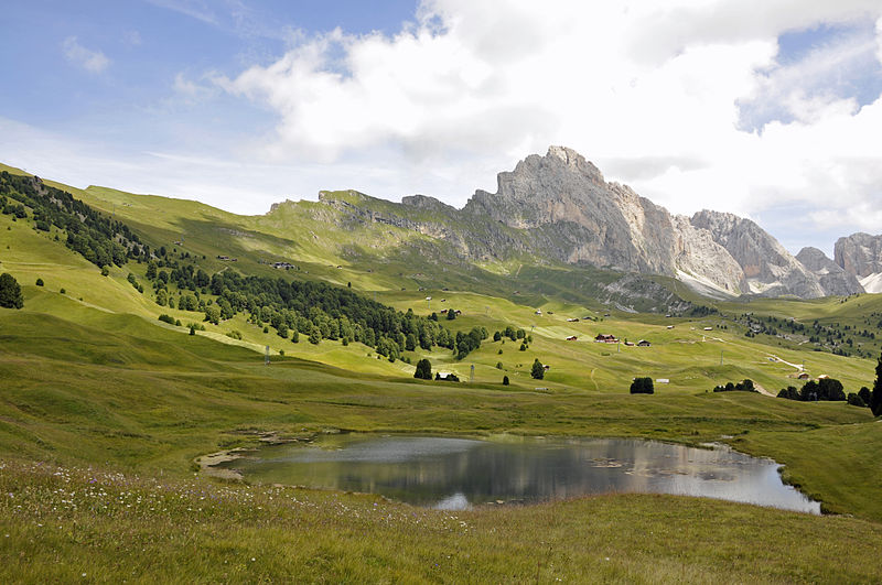
English: The lake Lech Sant in Gherdëina. Deutsch: Der Lech Sant See auf der Aschgler Alm in Gröden |
| Date | |
| Source | Own work |
| Author | Wolfgang Moroder |
| Feel free to use my photos, but please mention me as the author and send me a message. |
This image is not public domain. Please respect the copyright protection. It may only be used according to the rules mentioned here. This specifically excludes use in social media, if applicable terms of the licenses listed here not appropriate.
|

| Please do not upload an updated image here without consultation with the Author. The author would like to make corrections only at his own source. This ensures that the changes are preserved.
Please if you think that any changes should be required, please inform the author. Otherwise you can upload a new image with a new name. Please use one of the templates derivative or extract. |
| Camera location | | View this and other nearby images on: OpenStreetMap |
|---|
Licensing
[edit]
I, the copyright holder of this work, hereby publish it under the following licenses:
This file is licensed under the Creative Commons Attribution-Share Alike 3.0 Unported, 2.5 Generic, 2.0 Generic and 1.0 Generic license.
- You are free:
- to share – to copy, distribute and transmit the work
- to remix – to adapt the work
- Under the following conditions:
- attribution – You must give appropriate credit, provide a link to the license, and indicate if changes were made. You may do so in any reasonable manner, but not in any way that suggests the licensor endorses you or your use.
- share alike – If you remix, transform, or build upon the material, you must distribute your contributions under the same or compatible license as the original.

|
Permission is granted to copy, distribute and/or modify this document under the terms of the GNU Free Documentation License, Version 1.2 or any later version published by the Free Software Foundation; with no Invariant Sections, no Front-Cover Texts, and no Back-Cover Texts. A copy of the license is included in the section entitled GNU Free Documentation License. |
You may select the license of your choice.
| Annotations | This image is annotated: View the annotations at Commons |
This image has been assessed using the Quality image guidelines and is considered a Quality image.
|

|
This image has been assessed under the valued image criteria and is considered the most valued image on Commons within the scope: The "Lech Sant" lake, view with the Odles mountain range. You can see its nomination here. |
File history
Click on a date/time to view the file as it appeared at that time.
| Date/Time | Thumbnail | Dimensions | User | Comment | |
|---|---|---|---|---|---|
| current | 10:17, 27 November 2011 | | 4,288 × 2,848 (6.45 MB) | Moroder (talk | contribs) | == {{int:filedesc}} == {{Information |Description={{en|1=''Lech Sant'' the ''Stevia'' on the left and ''Sella Group'' in Gherdeina.}}{{en|1=Der ''Lech Sant'' auf der Aschgler Alm in Gröden}} |Source={{own}} |Author=Wolfgang Moroder |Date |
You cannot overwrite this file.
File usage on Commons
The following 8 pages use this file:
- User talk:Moroder/Archives 2008-2009-2010-2011
- User talk:Moroder/Archives 2014-1
- Commons:Quality images/Subject/Places/Natural structures/archive 2008 to 2012
- Commons:Quality images candidates/Archives November 2011
- Commons:Valued image candidates/Mont de Mastle Gherdëina.JPG
- Commons:Valued images by topic/Places/Natural/Mountain sites
- File:Lec de Mastlé Gherdëina.JPG
- File:Mont de Mastle Gherdëina.JPG
File usage on other wikis
The following other wikis use this file:
- Usage on br.wikipedia.org
- Usage on de.wikipedia.org
- Usage on it.wikipedia.org
- Usage on lld.wikipedia.org