File:Mapa de Colombia (topografía).svg
Jump to navigation
Jump to search

Size of this PNG preview of this SVG file: 449 × 600 pixels. Other resolutions: 180 × 240 pixels | 359 × 480 pixels | 575 × 768 pixels | 767 × 1,024 pixels | 1,534 × 2,048 pixels | 1,420 × 1,896 pixels.
Original file (SVG file, nominally 1,420 × 1,896 pixels, file size: 3.05 MB)
Captions
Captions
Add a one-line explanation of what this file represents
Summary
[edit]| Description |
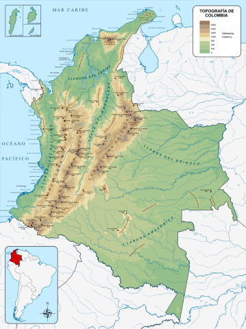
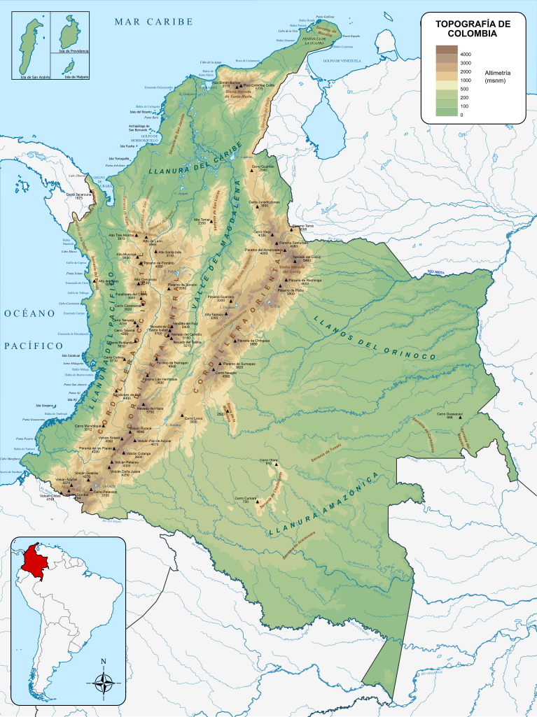
Español: Mapa topográfico de Colombia
English: Topographic map of Colombia |
| Date | |
| Source | Own work |
| Author | Milenioscuro |
| Other versions |
|
.svg)
.svg)
.svg)
.svg&action=edit§ion=1)
Licensing
[edit].svg&action=edit§ion=2)
I, the copyright holder of this work, hereby publish it under the following license:
This file is licensed under the Creative Commons Attribution-Share Alike 4.0 International license.
- You are free:
- to share – to copy, distribute and transmit the work
- to remix – to adapt the work
- Under the following conditions:
- attribution – You must give appropriate credit, provide a link to the license, and indicate if changes were made. You may do so in any reasonable manner, but not in any way that suggests the licensor endorses you or your use.
- share alike – If you remix, transform, or build upon the material, you must distribute your contributions under the same or compatible license as the original.
File history
Click on a date/time to view the file as it appeared at that time.
| Date/Time | Thumbnail | Dimensions | User | Comment | |
|---|---|---|---|---|---|
| current | 23:46, 24 February 2022 | | 1,420 × 1,896 (3.05 MB) | Milenioscuro (talk | contribs) | escala de relieve |
| 19:57, 24 February 2022 |  | 1,420 × 1,896 (3.01 MB) | Milenioscuro (talk | contribs) | Uploaded own work with UploadWizard |
You cannot overwrite this file.
File usage on Commons
The following 4 pages use this file:
File usage on other wikis
The following other wikis use this file:
- Usage on af.wikipedia.org
- Usage on ar.wikipedia.org
- Usage on ast.wikipedia.org
- Usage on avk.wikipedia.org
- Usage on be-tarask.wikipedia.org
- Usage on bn.wikipedia.org
- Usage on ckb.wikipedia.org
- Usage on da.wikipedia.org
- Usage on en.wikipedia.org
- Colombia
- Tumbes–Chocó–Magdalena
- Portal:Colombia
- Tropical Andes
- Cocora Valley
- Azufral
- Fundación ProAves
- List of birds of Colombia
- List of mammals of Colombia
- List of fishes of the Magdalena River
- Flora of Colombia
- Panama Bight
- Guajira–Barranquilla xeric scrub
- Bogotá savanna
- Cauca Valley dry forests
- Bahía Portete – Kaurrele National Natural Park
- List of non-marine molluscs of Colombia
- Sumapaz Páramo
- Colibri del Sol Bird Reserve
- Cerulean Warbler Bird Reserve
- Laguna de Sonso Nature Reserve
- National System of Protected Areas (Colombia)
- Alexander von Humboldt Biological Resources Research Institute
- Sinchi Amazonic Institute of Scientific Research
- National Natural Parks System (Colombia)
- John von Neumann Environmental Research Institute of the Pacific
- Proyecto Tití
- List of reptiles of Colombia
- List of primates of Colombia
- Endemic birds of Colombia
- List of lizards of Colombia
- List of snakes of Colombia
- Arví Park
- List of invasive species in Colombia
- List of butterflies of Colombia
- Chamicero de Perijá
- Campinarana
- List of flora and fauna named after the Muisca
- Thomas van der Hammen Natural Reserve
- Biodiversity of Colombia
- Caquetá moist forests
- Negro–Branco moist forests
View more global usage of this file.
.svg)
.svg&oldid=769650064)