Category:Maps of Colombia by User:Milenioscuro
Jump to navigation
Jump to search
Subcategories
This category has the following 5 subcategories, out of 5 total.
M
Media in category "Maps of Colombia by User:Milenioscuro"
The following 47 files are in this category, out of 47 total.
-
 Colombia continental location map.svg 512 × 692; 812 KB
-
 Colombia location map.svg 512 × 579; 1.07 MB
-
 Colombia location map2.svg 2,027 × 2,294; 735 KB
-
 Colombia locator map.svg 1,379 × 1,864; 172 KB
-
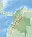 Colombia relief location map.jpg 2,028 × 2,294; 1.1 MB
-
 Colombia adm continental location map (colored).svg 1,380 × 1,864; 590 KB
-
 Colombia adm location map (colored).svg 2,027 × 2,294; 734 KB
-
 Colombia continental relief location map.jpg 1,378 × 1,864; 653 KB
-
 Colombia departamentos otros.svg 1,420 × 1,896; 398 KB
-
 Colombia location map (+municipalities).svg 1,379 × 1,864; 1,015 KB
-
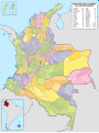
 Colombia Mapa Oficial.svg 2,072 × 2,339; 3.58 MB
-
 Colombia Political Locator.svg 1,002 × 1,137; 506 KB
-
 Colombia, administrative divisions - es - colored (+box).svg 1,380 × 1,864; 908 KB
-
 Colombia, administrative divisions - es - colored.svg 2,027 × 2,294; 1.69 MB
-
 Colombia, administrative divisions - es - monochrome (+box).svg 1,380 × 1,864; 908 KB
-
 Colombia, administrative divisions - es - monochrome.svg 2,027 × 2,294; 986 KB
-
 COVID-19 Outbreak Cases in Colombia by municipalities.svg 1,186 × 1,625; 1.24 MB
-
 Mapa de Colombia (+municipios).svg 1,420 × 1,896; 3.48 MB
-
 Mapa de Colombia (Carretera Panamericana).svg 1,420 × 1,896; 526 KB
-
 Mapa de Colombia (corporaciones autónomas regionales).svg 1,420 × 1,896; 1.08 MB
-
 Mapa de Colombia (departamentos).svg 1,420 × 1,896; 1.39 MB
-
 Mapa de Colombia (esperanza de vida 2010-2015).svg 1,420 × 1,896; 373 KB
-
 Mapa de Colombia (ferrocarriles).svg 1,420 × 1,896; 1.1 MB
-
 Mapa de Colombia (fronteras y tratados)-fr.svg 2,273 × 2,863; 4 MB
-
 Mapa de Colombia (fronteras y tratados).svg 2,237 × 2,847; 3.46 MB
-
 Mapa de Colombia (municipios).png 2,166 × 2,945; 296 KB
-
 Mapa de Colombia (orografía).svg 1,420 × 1,896; 898 KB
-
 Mapa de Colombia (parques naturales).svg 1,766 × 2,128; 2.64 MB
-
 Mapa de Colombia (población afrodescendiente 2005).svg 3,731 × 5,050; 4.63 MB
-
 Mapa de Colombia (población indígena 2005).svg 3,731 × 5,050; 4.65 MB
-
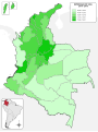
 Mapa de Colombia (población por departamentos 2012).svg 1,420 × 1,896; 387 KB
-
 Mapa de Colombia (provincias según el DANE).png 2,166 × 2,945; 269 KB
-
 Mapa de Colombia (provincias).svg 1,420 × 1,896; 2.79 MB
-
 Mapa de Colombia (red vial).svg 1,420 × 1,896; 2.24 MB
-
 Mapa de Colombia (Regiones de la Policia Nacional).svg 1,420 × 1,896; 1.06 MB
-
 Mapa de Colombia (relieve en blanco).svg 2,072 × 2,339; 3.17 MB
-
 Mapa de Colombia (relieve).svg 2,072 × 2,339; 1.79 MB
-
 Mapa de Colombia (relieve-ríos).svg 1,024 × 1,138; 825 KB
-
 Mapa de Colombia (ríos).svg 1,420 × 1,896; 3.39 MB
-
 Mapa de Colombia (subdivisiones).svg 7,455 × 10,112; 3.45 MB
-
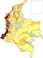
 Mapa de Colombia (tasa de mortalidad materna 2010).svg 1,420 × 1,896; 374 KB
-
 Mapa de Colombia (tipos de municipios).svg 1,420 × 1,896; 1.4 MB
-
 Mapa de Colombia (topografía).svg 1,420 × 1,896; 3.05 MB
-
 Mapa de Colombia (venezolanos residentes en 2005).svg 1,420 × 1,896; 373 KB
-
 Mapa de Colombia (áreas metropolitanas).svg 1,420 × 1,896; 1.39 MB
-
 Mapa de Colombia.svg 7,455 × 10,112; 6.14 MB
-
 Mapa del Eje Cafetero.svg 1,196 × 1,261; 933 KB


.svg)
.svg)


.svg)


.svg)

.svg)


.svg)
.svg)
.svg)
.svg)
.svg)
.svg)
-fr.svg)
.svg)
.png)
.svg)
.svg)
.svg)
.svg)
.svg)
.png)
.svg)
.svg)
.svg)
.svg)
.svg)
.svg)
.svg)
.svg)
.svg)
.svg)
.svg)
.svg)
.svg)

