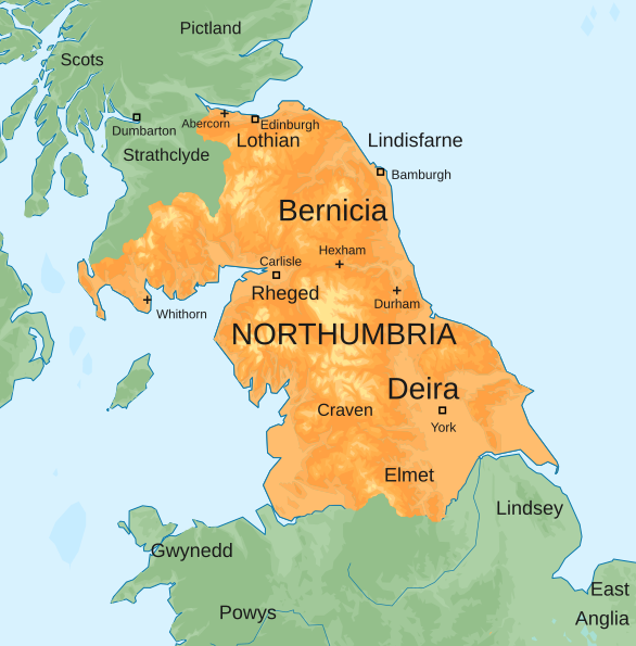
File:Map of the Kingdom of Northumbria around 700 AD.svg
From Wikimedia Commons, the free media repository
Jump to navigation
Jump to search

Size of this PNG preview of this SVG file: 586 × 594 pixels. Other resolutions: 237 × 240 pixels | 474 × 480 pixels | 758 × 768 pixels | 1,010 × 1,024 pixels | 2,020 × 2,048 pixels.
Original file (SVG file, nominally 586 × 594 pixels, file size: 800 KB)
File information
Structured data
Captions
Captions
Map of the Anglo-Saxon Kingdom of Northumbria around 700 AD
Carte du royaume anglo-saxon de Northumbrie vers l'an 700 après J-C.
Summary
[edit]| DescriptionMap of the Kingdom of Northumbria around 700 AD.svg |
English: Map of the Anglo-Saxon Kingdom of Northumbria around 700 AD |
| Date | |
| Source |
Blank topographic map of the British Isles.svg
|
| Author | Hogweard |
| Other versions |
|
Licensing
[edit]I, the copyright holder of this work, hereby publish it under the following license:
This file is licensed under the Creative Commons Attribution-Share Alike 4.0 International license.
- You are free:
- to share – to copy, distribute and transmit the work
- to remix – to adapt the work
- Under the following conditions:
- attribution – You must give appropriate credit, provide a link to the license, and indicate if changes were made. You may do so in any reasonable manner, but not in any way that suggests the licensor endorses you or your use.
- share alike – If you remix, transform, or build upon the material, you must distribute your contributions under the same or compatible license as the original.
File history
Click on a date/time to view the file as it appeared at that time.
| Date/Time | Thumbnail | Dimensions | User | Comment | |
|---|---|---|---|---|---|
| current | 17:41, 30 November 2022 |  | 586 × 594 (800 KB) | Purplewowies (talk | contribs) | Reverted to version as of 22:26, 14 June 2019 (UTC) The new upload last month appears to have primarily been intended to change the serif font to sans serif but whatever was used to do it caused serious problems with how this looks--some of the labels are even unreadable |
| 11:19, 23 October 2022 |  | 657 × 663 (392 KB) | Thingsomyipisntvisable (talk | contribs) | Main article: Edwin of Northumbria Edwin, like Æthelfrith, was king of both Deira and Bernicia and ruled them from 616 to 633. Under his reign the Isle of Man and the lands of Gwynedd in Northern Wales were incorporated into Northumbria. Edwin married Æthelburh, a Christian Princess from Kent in 625. He converted to Christianity two years later after a period of heavy consideration and after consulting numerous advisors.[48] Edwin fell in battle in 633 against Cadwallon of Gwynedd and the pag... | |
| 22:26, 14 June 2019 |  | 586 × 594 (800 KB) | Hogweard (talk | contribs) | =={{int:filedesc}}== {{Information |description={{en|1=Map of the Anglo-Saxon Kingdom of Northumbria around 700 AD}} |date=2019-06-14 |source={{f|Blank topographic map of the British Isles.svg}} *Derivative work: {{own}} |author={{u|Hogweard}} |permission= |other versions={{f|Map of the Anglo-Saxon Kingdom of Northumbria around 700 AD orange on green with labels.png}} }} =={{int:license-header}}== {{self|cc-by-sa-4.0}} Category:England Category:History of England [[Category:Scotland... |
You cannot overwrite this file.
File usage on Commons
The following 3 pages use this file:
File usage on other wikis
The following other wikis use this file:
- Usage on en.wikipedia.org
- Usage on fi.wikipedia.org
- Usage on fr.wikipedia.org
- Usage on he.wikipedia.org
- Usage on id.wikipedia.org
- Usage on it.wikipedia.org
- Usage on ko.wikipedia.org
- Usage on mk.wikipedia.org
- Usage on ru.wikipedia.org
- Usage on sco.wikipedia.org
- Usage on sv.wikipedia.org
- Usage on uk.wikipedia.org
- Usage on vi.wikipedia.org
- Usage on zh.wikipedia.org
Metadata
This file contains additional information such as Exif metadata which may have been added by the digital camera, scanner, or software program used to create or digitize it. If the file has been modified from its original state, some details such as the timestamp may not fully reflect those of the original file. The timestamp is only as accurate as the clock in the camera, and it may be completely wrong.
| Width | 585.74451 |
|---|---|
| Height | 594.25684 |

