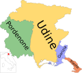
File:Map of region of Friuli-Venezia Giulia, Italy, with provinces-it.svg

Original file (SVG file, nominally 4,316 × 3,831 pixels, file size: 102 KB)
Captions
Captions
Summary
[edit]| DescriptionMap of region of Friuli-Venezia Giulia, Italy, with provinces-it.svg | (Italian version) |
| Date | |
| Source | Own work |
| Author | Vonvikken |
| Other versions |
      |
| This SVG file contains embedded text that can be translated into your language, using any capable SVG editor, text editor or the SVG Translate tool. For more information see: About translating SVG files. |
Licensing
[edit]| Public domainPublic domainfalsefalse |
| This work has been released into the public domain by its author, Vonvikken. This applies worldwide. In some countries this may not be legally possible; if so: |
File history
Click on a date/time to view the file as it appeared at that time.
| Date/Time | Thumbnail | Dimensions | User | Comment | |
|---|---|---|---|---|---|
| current | 21:29, 18 April 2020 |  | 4,316 × 3,831 (102 KB) | LametinoWiki (talk | contribs) | File uploaded using svgtranslate tool (https://tools.wmflabs.org/svgtranslate/). Added translation for fur. |
| 23:18, 15 September 2010 |  | 4,316 × 3,831 (102 KB) | Vonvikken (talk | contribs) | +Minimap | |
| 21:57, 15 September 2010 |  | 4,316 × 3,831 (68 KB) | Vonvikken (talk | contribs) | Reduced font dimension for "Udine" | |
| 12:54, 15 September 2010 |  | 4,316 × 3,831 (68 KB) | Vonvikken (talk | contribs) | Adjusted captions | |
| 12:53, 15 September 2010 |  | 4,316 × 3,831 (68 KB) | Vonvikken (talk | contribs) | == {{int:filedesc}} == {{Information |Description={{DescrMapRegionItaly|FRI|Italian}} |Source={{own}} |Author=Vonvikken |Date=2010-09-15 |Permission= |other_versions=100px|Blank |
You cannot overwrite this file.
File usage on Commons
The following 10 pages use this file:
- User:J budissin/Uploads/BiH/2020 April 11-20
- User:Vonvikken/Mappe
- User:Vonvikken/Mappe/Friuli-Venezia Giulia
- File:Friuli-Venezia Giulia Provinces.png
- File:Map of region of Friuli-Venezia Giulia, Italy, with provinces-de.svg
- File:Map of region of Friuli-Venezia Giulia, Italy, with provinces-el.svg
- File:Map of region of Friuli-Venezia Giulia, Italy, with provinces-fur.svg
- File:Map of region of Friuli-Venezia Giulia, Italy, with provinces-ka.svg
- File:Map of region of Friuli-Venezia Giulia, Italy, with provinces-ru.svg
- File:Map of region of Friuli-Venezia Giulia, Italy.svg
File usage on other wikis
The following other wikis use this file:
- Usage on ar.wikipedia.org
- Usage on bg.wikipedia.org
- Usage on ca.wikipedia.org
- Usage on cs.wikipedia.org
- Usage on cy.wikipedia.org
- Usage on da.wikipedia.org
- Usage on en.wikipedia.org
- Usage on en.wikivoyage.org
- Usage on eo.wikivoyage.org
- Usage on es.wikipedia.org
- Usage on et.wikipedia.org
- Usage on fi.wikipedia.org
- Usage on fr.wikipedia.org
- Usage on fur.wikipedia.org
- Usage on fy.wikipedia.org
- Usage on hu.wikipedia.org
- Usage on incubator.wikimedia.org
- Usage on it.wikipedia.org
- Usage on ja.wikipedia.org
- Usage on ku.wikipedia.org
- Usage on lij.wikipedia.org
- Usage on lld.wikipedia.org
- Usage on lmo.wikipedia.org
- Usage on mk.wikipedia.org
- Usage on nl.wikipedia.org
- Usage on sco.wikipedia.org
View more global usage of this file.
Metadata
This file contains additional information such as Exif metadata which may have been added by the digital camera, scanner, or software program used to create or digitize it. If the file has been modified from its original state, some details such as the timestamp may not fully reflect those of the original file. The timestamp is only as accurate as the clock in the camera, and it may be completely wrong.
| Width | 4316.0322 |
|---|---|
| Height | 3831.1279 |