File:Map of Texas highlighting Dallas County.svg
Jump to navigation
Jump to search

Size of this PNG preview of this SVG file: 631 × 600 pixels. Other resolutions: 253 × 240 pixels | 505 × 480 pixels | 808 × 768 pixels | 1,078 × 1,024 pixels | 2,155 × 2,048 pixels | 1,386 × 1,317 pixels.
Original file (SVG file, nominally 1,386 × 1,317 pixels, file size: 222 KB)
Captions
Captions
Add a one-line explanation of what this file represents
Summary
[edit]
| Description |
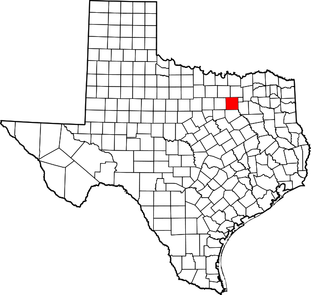
English: This is a locator map showing Dallas County in Texas. For more information, see Commons:United States county locator maps. |
| Date | |
| Source |
Own work: English: The maps use data from nationalatlas.gov, specifically countyp020.tar.gz on the Raw Data Download page. The maps also use state outline data from statesp020.tar.gz. The Florida maps use hydrogm020.tar.gz to display Lake Okeechobee. |
| Author | David Benbennick |
Licensing
[edit]
| I, the copyright holder of this work, release this work into the public domain. This applies worldwide. In some countries this may not be legally possible; if so: I grant anyone the right to use this work for any purpose, without any conditions, unless such conditions are required by law. |
File history
Click on a date/time to view the file as it appeared at that time.
| Date/Time | Thumbnail | Dimensions | User | Comment | |
|---|---|---|---|---|---|
| current | 00:42, 5 July 2024 | | 1,386 × 1,317 (222 KB) | Nux (talk | contribs) | fix rendering (remove clipping), uniform colors |
| 16:48, 12 February 2006 |  | 12,473 × 11,855 (304 KB) | David Benbennick (talk | contribs) | {{subst:User:Dbenbenn/clm|county=Dallas County|state=Texas|type=county}} |
You cannot overwrite this file.
File usage on Commons
The following 11 pages use this file:
- Category:Births in Dallas County, Texas
- Category:Cities in Dallas County, Texas
- Category:Dallas County, Texas
- Category:Deaths in Dallas County, Texas
- Category:Geography of Dallas County, Texas
- Category:Maps of Dallas County, Texas
- Category:People of Dallas County, Texas
- Category:Populated places in Dallas County, Texas
- Category:Schools in Dallas County, Texas
- Category:Towns in Dallas County, Texas
- Category:Transport in Dallas County, Texas
File usage on other wikis
The following other wikis use this file:
- Usage on af.wikipedia.org
- Usage on ar.wikipedia.org
- دالاس
- مقاطعة دالاس (تكساس)
- غراند براري (تكساس)
- إيرفينغ (تكساس)
- بالش سبرينغز
- أديسون (تكساس)
- دانكنفيل (تكساس)
- يونيفرسيتي بارك (تكساس)
- روليت (تكساس)
- ريتشاردسون (تكساس)
- سنيفيل (تكساس)
- مسكيت (تكساس)
- هايلاند بارك (تكساس)
- كارولتون (تكساس)
- سيدار هيل
- كوكريل هيل
- كومبين
- كوبيل (تكساس)
- دي سوتو (تكساس)
- فارمرز برانش
- فيريس (تكساس)
- غارلاند
- غلين هايتس
- غرابفين
- هاتشينز
- لانكستر (تكساس)
- لويسفيل (تكساس)
- أوفيلا
- ساتشس
- سيغوفيل
- ويلمر
- ويلي (تكساس)
- قالب:مقاطعة دالاس (تكساس)
- Usage on azb.wikipedia.org
- Usage on az.wikipedia.org
- Usage on be.wikipedia.org
- Usage on bg.wikipedia.org
- Usage on bpy.wikipedia.org
- Usage on ca.wikipedia.org
- Usage on cdo.wikipedia.org
- Usage on ceb.wikipedia.org
- Usage on cs.wikipedia.org
- Usage on cy.wikipedia.org
- Usage on de.wikipedia.org
View more global usage of this file.