File:Map of Nueva Esparta.svg
Jump to navigation
Jump to search

Size of this PNG preview of this SVG file: 800 × 540 pixels. Other resolutions: 320 × 216 pixels | 640 × 432 pixels | 1,024 × 691 pixels | 1,280 × 864 pixels | 2,560 × 1,728 pixels | 3,516 × 2,373 pixels.
Original file (SVG file, nominally 3,516 × 2,373 pixels, file size: 1.99 MB)
Captions
Captions
Add a one-line explanation of what this file represents
Summary
[edit]
| Description |
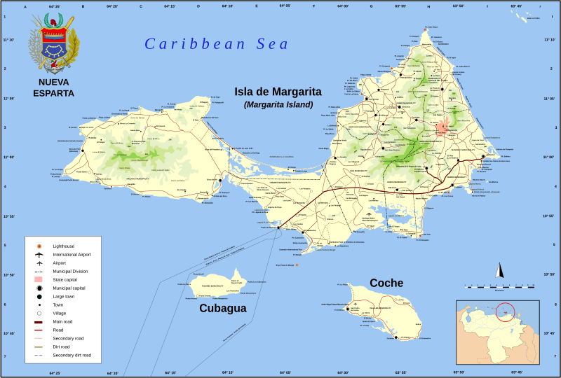
Español: Nueva Esparta es un estado federal de Venezuela, ubicado al noreste del país, siendo el único Estado Federal insular y el de menor superficie de la nación. El estado posee gran cantidad de monumentos históricos, en la iglesia de Santa Ana fue declarada la Tercera República de Venezuela, y, Simón Bolívar, su presidente. El Estado fue designado con ese nombre a partir del 12 de mayo de 1817, con el propósito de hacer un homenaje al heroísmo de los habitantes de la isla de Margarita durante la guerra de Independencia de Venezuela, calificado como "Heroísmo espartano", porque hizo recordar la valentía de los ciudadanos de la capital de la porción de Laconia (Esparta), en la península del Peloponeso, en la antigua Grecia. Aquí nacieron Luis Beltrán Prieto Figueroa, Santiago Mariño y otros grandes personajes de la historia regional y nacional.
English: Nueva Esparta (New Sparta) is one of the 23 states (estados) of Venezuela. It comprises Margarita Island (by far the largest and most important island), Coche, and uninhabited Cubagua. The state is the smallest one in area, and is located off the northeast Caribbean coast of Venezuela. It is the only insular state of Venuezuela. Its name comes from the heroísm shown by its inhabitants during the Venezuelan War of Independence, deemed similar to that of the Spartan soldiers of Ancient Greece. The main island of Margarita alone has an area of 934 km². In 1909 the state was constituted and in 1947 the island of Cubagua was added. Its capital city is La Asunción, but the main urban center is Porlamar.
Français : Nueva Esparta (Nouvelle Sparte) est un des 23 états (estados) du Venezuela. Il comprend l'Ile de Margarita (de loin la plus grande et plus importante), Coche, et Cubagua, inhabitée. L'état est le plus petit de la région, et est localisé de la côte antillaise au nord-est du Venezuela. C'est le seul état insulaire du Venezuela. Son nom vient de l'heroïsme montré par ses habitants pendant la Guerre d'indépendance venezuelienne , jugé semblable à celui des soldats spartiates de Grèce Ancienne. L'ile principale de Margarita a une surface de 934 km² à elle seule. En 1909 l'état a été constitué et en 1947 l'ile de Cubagua a été ajoutée. Sa ville capitale est Asunción, mais le centre urbain principal est Porlamar.
Aragonés: stato Nueba Esparta
Català: Estat de Nueva Esparta
Dansk: Nueva Esparta
Deutsch: Karte von Nueva Esparta
Bahasa Indonesia: Nueva Esparta
Italiano: Nueva Esparta
日本語: ベネズエラ、ヌエバ・エスパルタ州の地図。
Kernowek: Nueva Esparta
Nederlands: Nueva Esparta
Norsk nynorsk: Nueva Esparta
Norsk bokmål: Nueva Esparta
Polski: Nueva Esparta
Português: Estado de Nueva Esparta
Русский: Нуэва-Эспарта
Svenska: Nueva Esparta (Nya Sparta), en delstat i Venezuela.
Тоҷикӣ: Иёлоти Нуэва Эспарта
中文:新埃斯帕塔州 |
||
| Date | 25 November 2009, 23:23 (UTC) | ||
| Source | |||
| Author |
|
||
| SVG development |
|
I, the copyright holder of this work, hereby publish it under the following licenses:
This file is licensed under the Creative Commons Attribution-Share Alike 2.5 Generic, 2.0 Generic and 1.0 Generic license.
- You are free:
- to share – to copy, distribute and transmit the work
- to remix – to adapt the work
- Under the following conditions:
- attribution – You must give appropriate credit, provide a link to the license, and indicate if changes were made. You may do so in any reasonable manner, but not in any way that suggests the licensor endorses you or your use.
- share alike – If you remix, transform, or build upon the material, you must distribute your contributions under the same or compatible license as the original.
| This file is licensed under the Creative Commons Attribution-Share Alike 3.0 Unported license. | ||
| ||
| This licensing tag was added to this file as part of the GFDL licensing update. |

|
Permission is granted to copy, distribute and/or modify this document under the terms of the GNU Free Documentation License, Version 1.2 or any later version published by the Free Software Foundation; with no Invariant Sections, no Front-Cover Texts, and no Back-Cover Texts. A copy of the license is included in the section entitled GNU Free Documentation License. |
You may select the license of your choice.
Original upload log
[edit]
This image is a derivative work of the following images:
- File:Nueva Esparta Mapa Vial.svg licensed with Cc-by-sa-2.5,2.0,1.0, Cc-by-sa-3.0-migrated, GFDL
- 2008-11-01T19:03:53Z Wilfredor 3612x2508 (2032618 Bytes) {{Information |Description= |Source= |Date= |Author= |Permission= |other_versions= }}
- 2008-03-28T15:44:49Z Wilfredor 3612x2508 (828631 Bytes) {{Information |Description= {{es| Nueva Esparta es un estado federal de Venezuela, ubicado al noreste del país, siendo el único Estado Federal insular y el de menor superficie de la nación. El estado posee gran cantidad
- 2008-03-28T14:01:18Z Wilfredor 3612x2508 (817074 Bytes) {{Information |Description= {{es| Nueva Esparta es un estado federal de Venezuela, ubicado al noreste del país, siendo el único Estado Federal insular y el de menor superficie de la nación. El estado posee gran cantidad
- 2008-03-25T18:08:13Z Wilfredor 3612x2508 (817221 Bytes) {{Information |Description= {{es| Nueva Esparta es un estado federal de Venezuela, ubicado al noreste del país, siendo el único Estado Federal insular y el de menor superficie de la nación. El estado posee gran cantidad
- 2008-03-25T18:01:02Z Wilfredor 3612x2508 (817221 Bytes) {{Information |Description= {{es| Nueva Esparta es un estado federal de Venezuela, ubicado al noreste del país, siendo el único Estado Federal insular y el de menor superficie de la nación. El estado posee gran cantidad
- 2008-03-25T17:14:53Z Wilfredor 3612x2508 (816087 Bytes) {{Information |Description= {{es| Nueva Esparta es un estado federal de Venezuela, ubicado al noreste del país, siendo el único Estado Federal insular y el de menor superficie de la nación. El estado posee gran cantidad
- 2008-03-23T19:50:29Z Wilfredor 3612x2508 (4794503 Bytes) {{Information |Description= {{es| Nueva Esparta es un estado federal de Venezuela, ubicado al noreste del país, siendo el único Estado Federal insular y el de menor superficie de la nación. El estado posee gran cantidad
- 2008-03-23T18:22:15Z Wilfredor 3612x2508 (4750934 Bytes) {{Information |Description= {{es|Mapa vial del Estado Nueva Esparta, Venezuela}} {{en|Street map of Nueva Esparta}} |Source=self work, data obtained traveling across the zone with a GPS. |Date=2007 |Author=[[user:The Photographer|W
- 2007-10-30T21:12:34Z Wilfredor 3736x2672 (656674 Bytes) {{Information |Description= {{sp|Mapa vial del Estado Nueva Esparta, Venezuela}} {{en|Street map of Nueva Esparta}} |Source=self work, data obtained traveling across the zone with a GPS. |Date=2007 |Author=[[user:The Photographer|W
- 2007-10-30T15:38:06Z Wilfredor 3160x2192 (612513 Bytes) {{Information |Description= {{sp|Mapa vial del Estado Nueva Esparta, Venezuela}} {{en|Street map of Nueva Esparta}} |Source=self work, data obtained traveling across the zone with a GPS. |Date=2007 |Author=[[user:The Photographer|W
- 2007-10-29T22:11:19Z Wilfredor 3160x2192 (690240 Bytes) {{Information |Description= {{sp|Mapa vial del Estado Nueva Esparta, Venezuela}} {{en|Street map of Nueva Esparta}} |Source=self work, data obtained traveling across the zone with a GPS. |Date=2007 |Author=[[user:The Photographer|W
- 2007-10-29T21:57:01Z Wilfredor 3160x2164 (690240 Bytes) {{Information |Description= {{sp|Mapa vial del Estado Nueva Esparta, Venezuela}} {{en|Street map of Nueva Esparta}} |Source=self work, data obtained traveling across the zone with a GPS. |Date=2007 |Author=[[user:The Photographer|W
- 2007-10-29T20:38:41Z Wilfredor 3160x2176 (576095 Bytes) {{Information |Description= {{sp|Mapa vial del Estado Nueva Esparta, Venezuela}} {{en|Street map of Nueva Esparta}} |Source=self work, data obtained traveling across the zone with a GPS. |Date=2007 |Author=[[user:The Photographer|W
- 2007-10-29T20:28:03Z Wilfredor 3160x2176 (576182 Bytes) {{Information |Description= {{sp|Mapa vial del Estado Nueva Esparta, Venezuela}} {{en|Street map of Nueva Esparta}} |Source=self work, data obtained traveling across the zone with a GPS. |Date=2007 |Author=[[user:The Photographer|W
- 2007-10-27T16:45:54Z Wilfredor 3160x2176 (547031 Bytes) {{Information |Description= {{sp|Mapa vial del Estado Nueva Esparta, Venezuela}} {{en|Street map of Nueva Esparta}} |Source=self work, data obtained traveling across the zone with a GPS. |Date=2007 |Author=[[user:The Photographer|W
- 2007-10-23T16:54:58Z Wilfredor 3160x2176 (546971 Bytes) {{Information |Description= {{sp|Mapa vial del Estado Nueva Esparta, Venezuela}} {{en|Street map of Nueva Esparta}} |Source=self work, data obtained traveling across the zone with a GPS. |Date=2007 |Author=[[user:The Photographer|W
- 2007-10-04T13:52:59Z Wilfredor 3160x2176 (545499 Bytes) {{Information |Description= {{sp|Mapa vial del Estado Nueva Esparta, Venezuela}} {{en|Street map of Nueva Esparta}} |Source=self work, data obtained traveling across the zone with a GPS. |Date=2007 |Author=[[user:The Photographer|W
- 2007-08-28T23:41:01Z Wilfredor 3160x2176 (530845 Bytes) {{Information |Description= '''(Spanish):''' Mapa vial del Estado Nueva Esparta, Venezuela '''(English):''' Street map of Nueva Esparta |Source=self work |Date=2007 |Author=[[user:Wilfredor|Wilfredo R. Rodriguez H.]] |Permi
Uploaded with derivativeFX
File history
Click on a date/time to view the file as it appeared at that time.
| Date/Time | Thumbnail | Dimensions | User | Comment | |
|---|---|---|---|---|---|
| current | 14:52, 30 January 2010 | | 3,516 × 2,373 (1.99 MB) | MapMaster (talk | contribs) | Arghh! Same mistake. I need more coffee. My abject apologies |
| 14:45, 30 January 2010 |  | 15 × 15 (1.99 MB) | MapMaster (talk | contribs) | I messed up the map dimensions last time. Sorry | |
| 14:38, 30 January 2010 |  | 15 × 15 (1.99 MB) | MapMaster (talk | contribs) | Fixed big green text block. I also enlarged the Legend, inserted a new locator map of Venezuela, set the ocean color to the English Wikipedia standard, and enlarged the names of the islands. | |
| 19:30, 28 January 2010 |  | 3,612 × 2,508 (1.94 MB) | Malus Catulus (talk | contribs) | Reverted to version as of 12:51, 28 November 2009 | |
| 19:28, 28 January 2010 |  | 3,612 × 2,508 (1.61 MB) | Malus Catulus (talk | contribs) | Trying plain svg instead of inkscape svg to see if the text works out now. | |
| 12:51, 28 November 2009 |  | 3,612 × 2,508 (1.94 MB) | The Illusional Ministry (talk | contribs) | MAR CARIBE to CARIBBEAN SEA | |
| 23:37, 25 November 2009 |  | 3,612 × 2,508 (1.95 MB) | The Illusional Ministry (talk | contribs) | ||
| 23:24, 25 November 2009 |  | 3,612 × 2,508 (1.94 MB) | The Illusional Ministry (talk | contribs) | {{Information |Description={{es| Nueva Esparta es un estado federal de Venezuela, ubicado al noreste del país, siendo el único Estado Federal insular y el de menor superficie de la nación. El estado posee gran cantidad de monumentos históricos, en la |
You cannot overwrite this file.
File usage on Commons
The following page uses this file:
File usage on other wikis
The following other wikis use this file:
- Usage on es.wikipedia.org
- Usage on fr.wikipedia.org