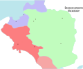
File:Map of Lithuania and Poland c. 1400 (ru).svg
From Wikimedia Commons, the free media repository
Jump to navigation
Jump to search

Size of this PNG preview of this SVG file: 574 × 475 pixels. Other resolutions: 290 × 240 pixels | 580 × 480 pixels | 928 × 768 pixels | 1,238 × 1,024 pixels | 2,475 × 2,048 pixels.
Original file (SVG file, nominally 574 × 475 pixels, file size: 53 KB)
File information
Structured data
Captions
Captions
Add a one-line explanation of what this file represents
Summary
[edit]| DescriptionMap of Lithuania and Poland c. 1400 (ru).svg |
English: Map of Lithuania and Poland, c.1400. Information taken mainly from the old German Map Image:Poland under Jagello.jpg, plus a few locations from a map in the book The Times Concise Atlas of World History, ISBN 0723006741. |
|||||||
| Date | (UTC) | |||||||
| Source | ||||||||
| Author |
|
|||||||
| Other versions | Derivative works of this file: Map of Lithuania and Poland c. 1400 es.svg | |||||||
| SVG development InfoField | This W3C-invalid map was created with an unknown SVG tool.
|
Licensing
[edit]I, the copyright holder of this work, hereby publish it under the following license:
| Public domainPublic domainfalsefalse |
| I, the copyright holder of this work, release this work into the public domain. This applies worldwide. In some countries this may not be legally possible; if so: I grant anyone the right to use this work for any purpose, without any conditions, unless such conditions are required by law. |
Original upload log
[edit]This image is a derivative work of the following images:
- File:Map_of_Lithuania_and_Poland_c._1400.jpg licensed with PD-self
- 2007-01-14T22:25:47Z Qp10qp 574x475 (38643 Bytes) {{Information| |Description=Map of Lithuania and Poland, c.1400. Information taken mainly from the old German Map [[Image:Poland under Jagello.jpg]] plus a few locations from a map in the book ''The Times Concise Atlas of Wor
Uploaded with derivativeFX
File history
Click on a date/time to view the file as it appeared at that time.
| Date/Time | Thumbnail | Dimensions | User | Comment | |
|---|---|---|---|---|---|
| current | 17:41, 6 November 2018 |  | 574 × 475 (53 KB) | JoKalliauer (talk | contribs) | real text again |
| 10:52, 14 May 2011 |  | 512 × 424 (374 KB) | AnonMoos (talk | contribs) | removing further flowtext nonsense | |
| 10:49, 14 May 2011 |  | 512 × 424 (374 KB) | AnonMoos (talk | contribs) | removing stupid InkScape flowtext nonsense | |
| 01:04, 14 May 2011 |  | 574 × 475 (452 KB) | ZooFari (talk | contribs) | attempt another fix | |
| 01:02, 14 May 2011 |  | 512 × 424 (375 KB) | ZooFari (talk | contribs) | Fix text | |
| 17:36, 25 August 2010 |  | 574 × 475 (90 KB) | Zair Probus (talk | contribs) | {{Information |Description=== Map of Lithuania and Poland, c.1400. Information taken mainly from the old German Map Image:Poland under Jagello.jpg, plus a few locations from a map in the book The Times Concise Atlas of World History, ISBN 0723006741. |Sou |
You cannot overwrite this file.
File usage on Commons
The following 3 pages use this file:
File usage on other wikis
The following other wikis use this file:
- Usage on lt.wikibooks.org
- Usage on uk.wikipedia.org
Metadata
This file contains additional information such as Exif metadata which may have been added by the digital camera, scanner, or software program used to create or digitize it. If the file has been modified from its original state, some details such as the timestamp may not fully reflect those of the original file. The timestamp is only as accurate as the clock in the camera, and it may be completely wrong.
| Width | 574 |
|---|---|
| Height | 475 |
