
File:Map of Corydon, Indiana from 1876 atlas.png

Size of this preview: 601 × 600 pixels. Other resolutions: 241 × 240 pixels | 481 × 480 pixels | 950 × 948 pixels.
Original file (950 × 948 pixels, file size: 880 KB, MIME type: image/png)
Captions
Captions
Add a one-line explanation of what this file represents
Summary
[edit]
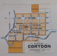
| Description | A map of the town of Corydon, the former capital of the state of Indiana |
| Date | |
| Source | Illustrated Historical Atlas of the State of Indiana |
| Author | Baskin, Forster and Company, Chicago |
| Open this image as an overlay in Google Earth (Google Maps, Bing) | (Help|Source) |
Licensing
[edit]
This media file is in the public domain in the United States. This applies to U.S. works where the copyright has expired, often because its first publication occurred prior to January 1, 1930, and if not then due to lack of notice or renewal. See this page for further explanation.
|
 | |
 |
File history
Click on a date/time to view the file as it appeared at that time.
| Date/Time | Thumbnail | Dimensions | User | Comment | |
|---|---|---|---|---|---|
| current | 02:58, 17 February 2012 | | 950 × 948 (880 KB) | Omnedon (talk | contribs) | == {{int:filedesc}} == {{Information |Description=A map of the town of Corydon, Indiana |Source=Illustrated Historical Atlas of the State of Indiana |Date=1876 |Author=Baskin, Forster and Company, Chicago |Permission= |other_versions= }} {{overlay}} == |
You cannot overwrite this file.
File usage on Commons
There are no pages that use this file.
File usage on other wikis
The following other wikis use this file:
- Usage on en.wikipedia.org
- Usage on pt.wikipedia.org