File:MH370 SIO search through Nov 2014.svg
Jump to navigation
Jump to search

Size of this PNG preview of this SVG file: 512 × 393 pixels. Other resolutions: 313 × 240 pixels | 625 × 480 pixels | 1,001 × 768 pixels | 1,280 × 983 pixels | 2,560 × 1,965 pixels.
Original file (SVG file, nominally 512 × 393 pixels, file size: 6.65 MB)
Captions
Captions
Add a one-line explanation of what this file represents
Summary
[edit]| Description |
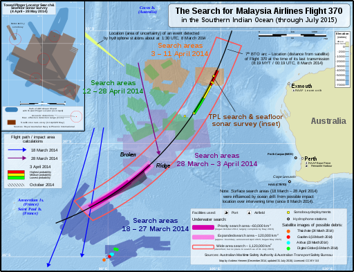
English: Map of the search areas for Malaysia Airlines Flight 370 in the Southern Indian Ocean (English).
Not shown:
中文(中国大陆):本地图展示了南印度洋海域马来西亚航空370号班机的搜寻区域。(英文)
未展示出来的有:
|
|||
| Date | ||||
| Source |
Own work The following sources were used for data included in the map. Locations (eg. where the search was conducted, locations of satellite debris & acoustic detections) are factual information which is not subject to copyright. Most sources are noted in the map. Main map
Towed Pinger Locator path & seafloor sonar survey location:
Background:
|
|||
| Author | Andrew Heneen | |||
| Permission (Reusing this file) |
I, the copyright holder of this work, hereby publish it under the following license: This file is licensed under the Creative Commons Attribution 4.0 International license.
|
|||
| Other versions |
|
|||
| SVG development |


| Annotations | This image is annotated: View the annotations at Commons |


File history
Click on a date/time to view the file as it appeared at that time.
| Date/Time | Thumbnail | Dimensions | User | Comment | |
|---|---|---|---|---|---|
| current | 09:45, 17 December 2017 | | 512 × 393 (6.65 MB) | JoKalliauer (talk | contribs) | removed rsvg-bug (flowtext), made file valid |
| 19:02, 10 August 2015 |  | 4,796 × 3,677 (6.76 MB) | AHeneen (talk | contribs) | fix typos | |
| 20:31, 31 July 2015 |  | 4,796 × 3,677 (6.75 MB) | AHeneen (talk | contribs) | Updated to 31 July 2015, including the expanded underwater search area (announced April 2015) and years were added to dates; to accommodate these changes, some unchanged elements were moved to different positions | |
| 06:50, 13 December 2014 |  | 4,796 × 3,677 (6.75 MB) | AHeneen (talk | contribs) | 30° label was not aligned properly | |
| 06:19, 13 December 2014 |  | 4,796 × 3,677 (6.75 MB) | AHeneen (talk | contribs) | minor adjustment to legend | |
| 07:03, 9 December 2014 |  | 4,796 × 3,677 (6.74 MB) | AHeneen (talk | contribs) | Remove "Background: Natural Earth" from lower right box | |
| 06:28, 9 December 2014 |  | 4,796 × 3,677 (6.74 MB) | AHeneen (talk | contribs) | Deleted hidden layers from SVG file (file size reduced about 40%)...now hopefully PNG preview issue is fixed | |
| 06:20, 9 December 2014 |  | 4,796 × 3,677 (10.43 MB) | AHeneen (talk | contribs) | changes that will hopefully fix an issue with rendering PNG preview | |
| 05:40, 9 December 2014 |  | 4,796 × 3,677 (10.43 MB) | AHeneen (talk | contribs) | Change to a color relief background with hillshade (now uses ETOPO1 data from NASA for bathymetry & Natural Earth for Australia outline); lat/long gradients are now vectors, which will hopefully resolve issues with them disappearing in PNG preview | |
| 02:44, 8 December 2014 |  | 4,796 × 3,677 (3.98 MB) | AHeneen (talk | contribs) | Additional flight paths & some clean up / improvements |
You cannot overwrite this file.
File usage on Commons
The following 13 pages use this file:
- User:JoKalliauer
- User:JoKalliauer/Pictures
- Commons:Quality images candidates/Archives December 18 2014
- Commons:WikiProject Aviation/recent uploads/2014 December 6
- Commons:WikiProject Aviation/recent uploads/2015 August 10
- Commons:WikiProject Aviation/recent uploads/2015 July 31
- Commons:WikiProject Aviation/recent uploads/2017 December 17
- File:MH370 SIO search-en.svg
- File:MH370 SIO search-zh-s.svg
- File:MH370 SIO search.png
- File:MH370 SIO search through Nov 2014.svg
- File:MH370 TPL search and sonar survey.svg
- File:MH370 search March through October 2014.svg
File usage on other wikis
The following other wikis use this file:
- Usage on de.wikipedia.org