File:Lop Nur, Xinjiang, China.jpg
Jump to navigation
Jump to search

Size of this preview: 588 × 600 pixels. Other resolutions: 235 × 240 pixels | 470 × 480 pixels | 753 × 768 pixels | 1,004 × 1,024 pixels | 2,366 × 2,414 pixels.
Original file (2,366 × 2,414 pixels, file size: 372 KB, MIME type: image/jpeg)
Captions
Captions
Add a one-line explanation of what this file represents
Summary
[edit]| Description |
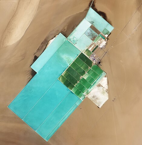
English: Natural-colour image of Lop Nur. The rectangular shapes in this image show the bright colours characteristic of solar evaporation ponds. Around the evaporation ponds are the earth tones typical of sandy desert. |
|||||
| Date | ||||||
| Source | NASA Earth Observatory | |||||
| Author | Jesse Allen and Robert Simmon | |||||
| Permission (Reusing this file) |
|

| Camera location | | View this and other nearby images on: OpenStreetMap |
|---|
Image captured by the Advanced Land Imager (ALI) on NASA’s Earth Observing-1 (EO-1) satellite. EO-1 ALI data provided courtesy of the NASA EO-1 team.
File history
Click on a date/time to view the file as it appeared at that time.
| Date/Time | Thumbnail | Dimensions | User | Comment | |
|---|---|---|---|---|---|
| current | 10:07, 20 June 2011 | | 2,366 × 2,414 (372 KB) | Originalwana (talk | contribs) | {{Information |Description ={{en|1=Natural-colour image of Lop Nur. The rectangular shapes in this image show the bright colours characteristic of solar evaporation ponds. Around the evaporation ponds are the earth tones typical of sandy desert. }} |
You cannot overwrite this file.
File usage on Commons
The following page uses this file:
File usage on other wikis
The following other wikis use this file:
- Usage on ro.wikipedia.org
- Usage on sl.wikipedia.org
- Usage on te.wikipedia.org
- Usage on zh.wikipedia.org