File:Lauchert Bittelschießer-Täle Schwäbische Alb 5.jpg
Jump to navigation
Jump to search

Size of this preview: 400 × 600 pixels. Other resolutions: 160 × 240 pixels | 320 × 480 pixels.
Original file (800 × 1,200 pixels, file size: 308 KB, MIME type: image/jpeg)
Captions
Captions
Add a one-line explanation of what this file represents
Summary
[edit]
| Description |
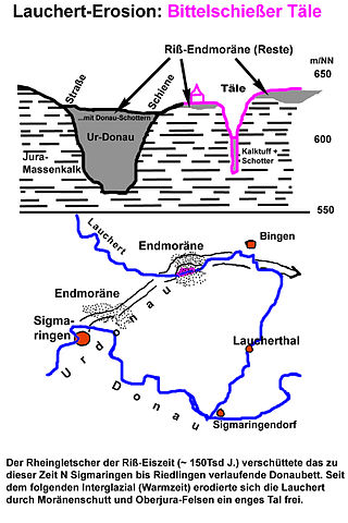
English: Extraordinary morphology of the landform of lower river Lauchert around the geotope "Bittelschießer Täle", Swabian Alb.
From the end of the Mindel-Eiszeit (German), ~ 0,900Ma, the Upper Danube transitionally used and deepened the river bed of the Lauchert, until, in the mid Riß-Eiszeit (German), ~ 0,150Ma, the Rhine Glacier advanced twice, dammed up and blocked the Danube and the Lauchert, filled the Danube bed and packed the terrain with moraines. In the next interglacial the Lauchert eroded the moraine debris and then cut a new canyon into a massive limestone, rather than reusing its former bed right next to it. The Danube carved itself a new bed further south. Deutsch: Ungewöhnliche geologische Situation beim Geotop Bittelschießer Täle, Unterlauf der Lauchert, Schwäbische Alb. Eine nach-mindeleiszeitliche (~ 0,900Ma) Obere Donau benutzte und vertiefte in der Mittleren Riß-Eiszeit (~ 0,150Ma) das alte Lauchertbett bis zur vollständigen Plombierung durch den vordringenden Rheingletscher. Das Bittelschießer Täle ist eine Neuschaffung der Lauchert. Nachdem es den Gletscherschutt ausgeräumt hatte nutzte es wieder sein altes Bett, jedoch nicht durchgehend. Vielmehr schnitt es in einen im Weg stehenden Massenkalkhügel ein Canyon. |
| Date | (upload) |
| Source | Own work |
| Author | Ustill |
Licensing
[edit]
I, the copyright holder of this work, hereby publish it under the following license:
This file is licensed under the Creative Commons Attribution-Share Alike 3.0 Unported license.
- You are free:
- to share – to copy, distribute and transmit the work
- to remix – to adapt the work
- Under the following conditions:
- attribution – You must give appropriate credit, provide a link to the license, and indicate if changes were made. You may do so in any reasonable manner, but not in any way that suggests the licensor endorses you or your use.
- share alike – If you remix, transform, or build upon the material, you must distribute your contributions under the same or compatible license as the original.
File history
Click on a date/time to view the file as it appeared at that time.
| Date/Time | Thumbnail | Dimensions | User | Comment | |
|---|---|---|---|---|---|
| current | 16:03, 8 February 2013 | | 800 × 1,200 (308 KB) | Ustill (talk | contribs) | User created page with UploadWizard |
You cannot overwrite this file.
File usage on Commons
There are no pages that use this file.
File usage on other wikis
The following other wikis use this file:
- Usage on de.wikipedia.org
Metadata
Categories:
- Geology of Germany
- Lauchert
- Schwäbische Alb
- Terminal moraines in Baden-Württemberg
- Geological cross sections of Baden-Württemberg
- Geological maps of Germany
- Geological cross sections in German
- Bingen (Landkreis Sigmaringen)
- Glacial geomorphology of Baden-Württemberg
- Fluvial erosion in Germany
- Pleistocene geology of Baden-Württemberg
- Riss glaciation in Germany
- Pleistocene glaciations in Baden-Württemberg
- Mindel glaciation
- Muschelkalk in Germany