File:LIDAR field yield.jpg
LIDAR_field_yield.jpg (288 × 185 pixels, file size: 110 KB, MIME type: image/jpeg)
Captions
Captions
Summary
[edit]| DescriptionLIDAR field yield.jpg |
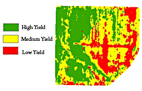
English: Agricultural Research Service researchers have developed a way to make more precise agricultural maps of fields from data generated by LIDAR (light detection and ranging) sensors to help farmers target more of their resources to the highest-yielding parts of their fields. |
| Date | |
| Source | https://www.ars.usda.gov/is/pr/2010/100609.htm |
| Author | USDA/ARS/James M. McKinion |
Licensing
[edit]| Public domainPublic domainfalsefalse |
| This image is in the public domain because it contains materials that originally came from the Agricultural Research Service, the research agency of the United States Department of Agriculture.
العربية ∙ dansk ∙ Deutsch ∙ English ∙ español ∙ فارسی ∙ français ∙ italiano ∙ 日本語 ∙ македонски ∙ മലയാളം ∙ Nederlands ∙ português ∙ sicilianu ∙ Türkçe ∙ Tiếng Việt ∙ 中文 ∙ +/− |
Original upload log
[edit]Transferred from en.wikipedia to Commons using FtCG.
| Date/Time | Dimensions | User | Comment |
|---|---|---|---|
| 10:39, 7 September 2010 | 288 × 185 (112,175 bytes) | w:en:Huntster (talk | contribs) | (Crop and rm compression artifacts.) |
| 21:04, 17 August 2010 | 288 × 252 (77,555 bytes) | w:en:Wikiproject1400 (talk | contribs) | (Agricultural Research Service scientists have developed a way to incorporate LIDAR with yield rates on agricultural fields. This technology will help farmers direct their resources towars the high-yield sections of their land. (United States Department o) |
File history
Click on a date/time to view the file as it appeared at that time.
| Date/Time | Thumbnail | Dimensions | User | Comment | |
|---|---|---|---|---|---|
| current | 10:24, 31 December 2011 |  | 288 × 185 (110 KB) | Huntster (talk | contribs) | Transferred from en.wikipedia: see original upload log above |
You cannot overwrite this file.
File usage on Commons
There are no pages that use this file.
File usage on other wikis
The following other wikis use this file:
Metadata
This file contains additional information such as Exif metadata which may have been added by the digital camera, scanner, or software program used to create or digitize it. If the file has been modified from its original state, some details such as the timestamp may not fully reflect those of the original file. The timestamp is only as accurate as the clock in the camera, and it may be completely wrong.
| Orientation | Normal |
|---|---|
| Horizontal resolution | 72 dpi |
| Vertical resolution | 72 dpi |
| Software used | Adobe Photoshop CS3 Windows |
| File change date and time | 05:39, 7 September 2010 |
| Y and C positioning | Co-sited |
| Exif version | 2.2 |
| Meaning of each component |
|
| Supported Flashpix version | 1 |
| Color space | sRGB |
