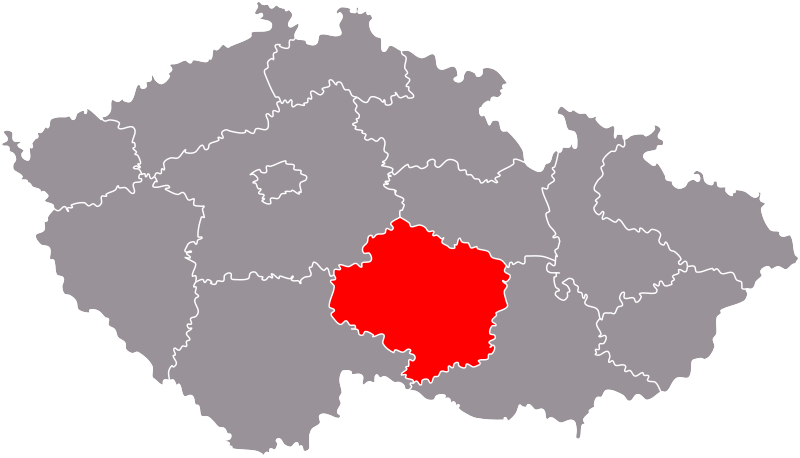
File:Kraj Vysocina.svg
From Wikimedia Commons, the free media repository
Jump to navigation
Jump to search

Size of this PNG preview of this SVG file: 800 × 458 pixels. Other resolutions: 320 × 183 pixels | 640 × 366 pixels | 1,024 × 586 pixels | 1,280 × 733 pixels | 2,560 × 1,465 pixels | 3,417 × 1,956 pixels.
Original file (SVG file, nominally 3,417 × 1,956 pixels, file size: 177 KB)
File information
Structured data
Captions
Captions
Add a one-line explanation of what this file represents
Summary
[edit]cs: Kraj Vysočina na mapě Česka.
Založeno na Image:Cesko-kraje.svg, zeditoval Miraceti.
en: Location of the Vysočina Region in Czechia.
Based on Image:Cesko-kraje.svg, edited by Miraceti.
Licensing
[edit]
|
Permission is granted to copy, distribute and/or modify this document under the terms of the GNU Free Documentation License, Version 1.2 or any later version published by the Free Software Foundation; with no Invariant Sections, no Front-Cover Texts, and no Back-Cover Texts. A copy of the license is included in the section entitled GNU Free Documentation License.http://www.gnu.org/copyleft/fdl.htmlGFDLGNU Free Documentation Licensetruetrue |
| This file is licensed under the Creative Commons Attribution-Share Alike 3.0 Unported license. | ||
| ||
| This licensing tag was added to this file as part of the GFDL licensing update.http://creativecommons.org/licenses/by-sa/3.0/CC BY-SA 3.0Creative Commons Attribution-Share Alike 3.0truetrue |
File history
Click on a date/time to view the file as it appeared at that time.
| Date/Time | Thumbnail | Dimensions | User | Comment | |
|---|---|---|---|---|---|
| current | 17:18, 16 August 2009 |  | 3,417 × 1,956 (177 KB) | Ria (talk | contribs) | new color scheme - more informations: cs.wikipedia.org - WP:Mapy |
| 02:36, 2 July 2006 |  | 3,417 × 1,956 (110 KB) | Happenstance (talk | contribs) | Kraj Vysocina |
You cannot overwrite this file.
File usage on Commons
The following 3 pages use this file:
File usage on other wikis
The following other wikis use this file:
- Usage on az.wikipedia.org
- Usage on be-tarask.wikipedia.org
- Usage on bg.wikipedia.org
- Usage on br.wikipedia.org
- Usage on cs.wikipedia.org
- Usage on da.wikipedia.org
- Usage on de.wikipedia.org
- Verwaltungsgliederung Tschechiens
- Burg Roštejn
- Burg Lipnice
- Burg Ledeč nad Sázavou
- Schloss Jaroměřice
- Schloss Telč
- Schloss Náměšť nad Oslavou
- Schloss Pohled
- Vorlage:Navigationsleiste Burgen und Schlösser in der Region Vysočina
- NUTS:CZ
- Flaggen und Wappen der tschechischen Regionen
- Burg Aueršperk
- Burg Dalečín
- Schloss Dalečín
- Burg Pyšolec
- Burg Zubštejn
- Burg Templštejn (Oslava)
- Liste der Naturschutzgebiete im Kraj Vysočina
- Burg Štarkov
- Usage on de.wikivoyage.org
- Usage on eo.wikipedia.org
- Usage on eu.wikipedia.org
- Usage on fa.wikipedia.org
- Usage on hr.wikipedia.org
- Usage on hsb.wikipedia.org
- Usage on hu.wikipedia.org
- Usage on ja.wikipedia.org
- Usage on ko.wikipedia.org
- Usage on mk.wikipedia.org
- Usage on ms.wikipedia.org
- Usage on nl.wikipedia.org
- Usage on pam.wikipedia.org
- Usage on pl.wikipedia.org
- Usage on pl.wikivoyage.org
- Usage on pt.wikipedia.org
- Usage on ro.wikipedia.org
- Usage on ru.wikipedia.org
- Usage on ru.wikinews.org
- Usage on sk.wikipedia.org
- Usage on sv.wikipedia.org
- Usage on tr.wikipedia.org
View more global usage of this file.