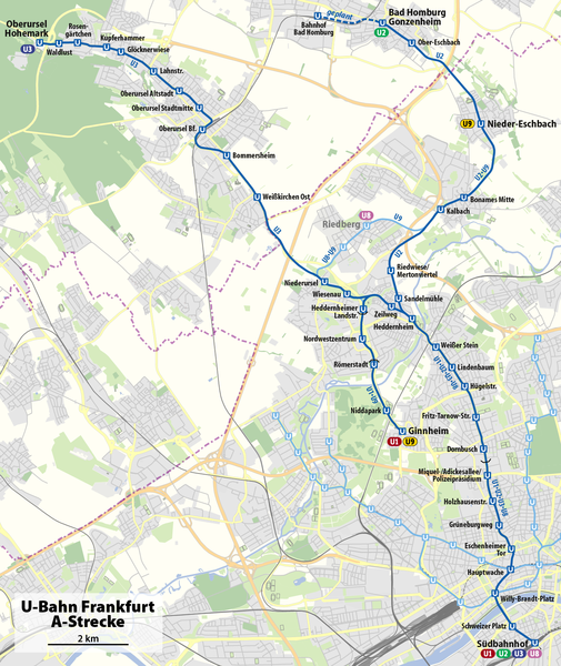
File:Karte U-Bahn Frankfurt A-Strecke.png
From Wikimedia Commons, the free media repository
Jump to navigation
Jump to search

Size of this preview: 505 × 600 pixels. Other resolutions: 202 × 240 pixels | 404 × 480 pixels | 647 × 768 pixels | 862 × 1,024 pixels | 1,398 × 1,660 pixels.
Original file (1,398 × 1,660 pixels, file size: 845 KB, MIME type: image/png)
File information
Structured data
Captions
Captions
Add a one-line explanation of what this file represents
Summary
[edit]| DescriptionKarte U-Bahn Frankfurt A-Strecke.png |
Deutsch: Karte der A-Strecke der U-Bahn Frankfurt
English: Map of line A of Frankfurt U-Bahn |
||||||||||||
| Date | |||||||||||||
| Source | OpenStreetMap | ||||||||||||
| Author | NordNordWest | ||||||||||||
| Permission (Reusing this file) |
|

|
This map has been made or improved in the German Kartenwerkstatt (Map Lab). You can propose maps to improve as well.
azərbaycanca ∙ čeština ∙ Deutsch ∙ Deutsch (Sie-Form) ∙ English ∙ español ∙ français ∙ italiano ∙ latviešu ∙ magyar ∙ Nederlands ∙ Plattdüütsch ∙ polski ∙ português ∙ română ∙ sicilianu ∙ slovenščina ∙ suomi ∙ македонски ∙ русский ∙ ქართული ∙ հայերեն ∙ বাংলা ∙ ไทย ∙ +/−
|
File history
Click on a date/time to view the file as it appeared at that time.
| Date/Time | Thumbnail | Dimensions | User | Comment | |
|---|---|---|---|---|---|
| current | 18:20, 2 January 2019 |  | 1,398 × 1,660 (845 KB) | NordNordWest (talk | contribs) | upd |
| 17:27, 4 October 2017 |  | 1,398 × 1,660 (845 KB) | NordNordWest (talk | contribs) | upd | |
| 19:58, 8 December 2011 |  | 1,398 × 1,660 (786 KB) | NordNordWest (talk | contribs) | corr | |
| 18:03, 6 December 2011 |  | 1,398 × 1,660 (779 KB) | NordNordWest (talk | contribs) | == {{int:filedesc}} == {{Information |Description= {{de|Karte der A-Strecke der U-Bahn Frankfurt}} {{en|Map of line A of Frankfurt U-Bahn}} |Source=OpenStreetMap |Date=2011-12-06 |Author={{U|NordNordWest} |
You cannot overwrite this file.
File usage on Commons
The following 8 pages use this file:
- User:Chumwa/OgreBot/Potential transport maps/2017 October 1-10
- User:Chumwa/OgreBot/Potential transport maps/2019 January 1-10
- User:Chumwa/OgreBot/Public transport information/2017 October 1-10
- User:Chumwa/OgreBot/Public transport information/2019 January 1-10
- User:Chumwa/OgreBot/Transport Maps/2017 October 1-10
- User:Chumwa/OgreBot/Transport Maps/2019 January 1-10
- User:Chumwa/OgreBot/Travel and communication maps/2017 October 1-10
- User:Chumwa/OgreBot/Travel and communication maps/2019 January 1-10
File usage on other wikis
The following other wikis use this file:
- Usage on de.wikipedia.org
- Usage on fr.wikipedia.org
- Usage on no.wikipedia.org
- Usage on sv.wikipedia.org
- Usage on www.wikidata.org
- Usage on zh.wikipedia.org
Metadata
This file contains additional information such as Exif metadata which may have been added by the digital camera, scanner, or software program used to create or digitize it. If the file has been modified from its original state, some details such as the timestamp may not fully reflect those of the original file. The timestamp is only as accurate as the clock in the camera, and it may be completely wrong.
| Horizontal resolution | 59.06 dpc |
|---|---|
| Vertical resolution | 59.06 dpc |
| Software used |
Hidden categories: