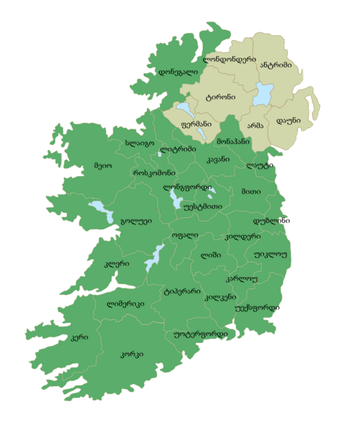
File:Ireland trad counties named ka.png
From Wikimedia Commons, the free media repository
Jump to navigation
Jump to search

Size of this preview: 480 × 600 pixels. Other resolutions: 192 × 240 pixels | 384 × 480 pixels | 614 × 768 pixels | 819 × 1,024 pixels | 2,000 × 2,500 pixels.
Original file (2,000 × 2,500 pixels, file size: 459 KB, MIME type: image/png)
File information
Structured data
Captions
Captions
Add a one-line explanation of what this file represents
Summary
[edit]| DescriptionIreland trad counties named ka.png |
ქართული: ირლანდიის საგრაფოების რუკა ქართული სახელწოდებებით, ჩრდილოეთ ირლანდიის საგრაფოები ნაჩვენებია ღია ნაცრისფრად. English: Map of Ireland's counties with Georgian names, Northern Ireland counties colored tan. |
| Date | |
| Source | |
| Author |
|
| Other versions |
|
| This is a retouched picture, which means that it has been digitally altered from its original version. The original can be viewed here: Ireland trad counties named.svg:
|
Licensing
[edit]This file is licensed under the Creative Commons Attribution-Share Alike 3.0 Unported license.
- You are free:
- to share – to copy, distribute and transmit the work
- to remix – to adapt the work
- Under the following conditions:
- attribution – You must give appropriate credit, provide a link to the license, and indicate if changes were made. You may do so in any reasonable manner, but not in any way that suggests the licensor endorses you or your use.
- share alike – If you remix, transform, or build upon the material, you must distribute your contributions under the same or compatible license as the original.
File history
Click on a date/time to view the file as it appeared at that time.
| Date/Time | Thumbnail | Dimensions | User | Comment | |
|---|---|---|---|---|---|
| current | 14:30, 5 July 2015 |  | 2,000 × 2,500 (459 KB) | Cmdrjameson (talk | contribs) | Compressed with pngout. Reduced by 191kB (29% decrease). |
| 21:53, 2 February 2013 |  | 2,000 × 2,500 (651 KB) | Giorgi Balakhadze (talk | contribs) | User created page with UploadWizard |
You cannot overwrite this file.
File usage on Commons
The following 4 pages use this file:
File usage on other wikis
The following other wikis use this file:
- Usage on ka.wikipedia.org
- ირლანდია
- დუბლინი
- კონაქტი
- თარგი:ირლანდიის ადმინისტრაციული დაყოფა
- მანსტერი
- ლენსტერი
- ოლსტერი
- ლიტრიმის საგრაფო
- როსკომონის საგრაფო
- სლაიგოს საგრაფო
- მეიოს საგრაფო
- თარგი:ირლანდიის საგრაფოები
- ირლანდიის ადმინისტრაციული დაყოფა
- თარგის განხილვა:ირლანდიის საგრაფოები
- გოლუეის საგრაფო
- დუბლინის საგრაფო
- დან-ლერი-რატდაუნის საგრაფო
- სამხრეთ დუბლინის საგრაფო
- ფინგალის საგრაფო
- კარლოუს საგრაფო
- კილდერის საგრაფო
- კილკენის საგრაფო
- ლაუთის საგრაფო
- ლიშის საგრაფო
- ლონგფორდის საგრაფო
- მითის საგრაფო
- ოფალის საგრაფო
- უესტმითის საგრაფო
- უიკლოუს საგრაფო
- უექსფორდის საგრაფო
- ბანკლოდი
- ირლანდიის დასახლებული პუნქტები
- ტალოუ (კარლოუ)
- გრეიგნამანა
- არლესი
- ბალიმერფი
- ბალინკილინი
- ბალონი
- ბორისი
- გრეინჯფორდი
- კერნანსტაუნი
- კილდავინი
- კლონგალი
- კლონმორი
- კულკენო
- ლოხლინბრიჯი
- მიშალი
- ნერნი
- ოლდლოჰლინი
- რათვილი
View more global usage of this file.
Metadata
This file contains additional information such as Exif metadata which may have been added by the digital camera, scanner, or software program used to create or digitize it. If the file has been modified from its original state, some details such as the timestamp may not fully reflect those of the original file. The timestamp is only as accurate as the clock in the camera, and it may be completely wrong.
| Horizontal resolution | 28.35 dpc |
|---|---|
| Vertical resolution | 28.35 dpc |
Hidden categories:


