File:IndiaMap.png
From Wikimedia Commons, the free media repository
Jump to navigation
Jump to search
IndiaMap.png (474 × 547 pixels, file size: 182 KB, MIME type: image/png)
File information
Structured data
Captions
Captions
Add a one-line explanation of what this file represents
Summary
[edit]| DescriptionIndiaMap.png |
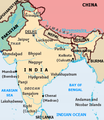
English: The current map is like prof of concept & request for comments map. Don't worry it will be improved. Please see the discussion page more info.
Map of India, uploaded for discussion. The map shows the
|
| Date | 17 August 2004 (original upload date) |
| Source |
Created and uploaded by User:Ankur Made using Inkscape and GIMP. Based on [1] [2] [3] [4] (original maps were produced by the U.S. Central Intelligence Agency.) |
| Author | Ankur at English Wikipedia |
Licensing
[edit]| This file is licensed under the Creative Commons Attribution-Share Alike 3.0 Unported license. Subject to disclaimers. | ||
| ||
| This licensing tag was added to this file as part of the GFDL licensing update.http://creativecommons.org/licenses/by-sa/3.0/CC BY-SA 3.0Creative Commons Attribution-Share Alike 3.0truetrue |

|
Permission is granted to copy, distribute and/or modify this document under the terms of the GNU Free Documentation License, Version 1.2 or any later version published by the Free Software Foundation; with no Invariant Sections, no Front-Cover Texts, and no Back-Cover Texts. A copy of the license is included in the section entitled GNU Free Documentation License. Subject to disclaimers.http://www.gnu.org/copyleft/fdl.htmlGFDLGNU Free Documentation Licensetruetrue |
Original upload log
[edit]The original description page was here. All following user names refer to en.wikipedia.
- 2004-12-31 11:56 Ankur 474×547× (186346 bytes) lakswadeep->lashadweep
- 2004-11-03 09:16 Kums 473×546× (219107 bytes) Reverted to earlier revision
- 2004-11-03 09:12 Kums 472×543× (223882 bytes) Reverted to earlier revision
- 2004-09-16 05:02 Raul654 473×546× (219107 bytes) Reverted to earlier revision
- 2004-09-16 05:01 Raul654 472×547× (216446 bytes) Reverted to earlier revision
- 2004-09-14 21:56 Ankur 473×546× (219107 bytes) Rivers
- 2004-09-14 06:33 Raul654 472×547× (216446 bytes)
- 2004-09-13 10:11 Ankur 472×547× (193385 bytes)
- 2004-09-12 18:01 Raul654 472×543× (223882 bytes)
- 2004-09-12 10:33 Ankur 472×543× (202474 bytes) Complet(er)
- 2004-08-17 22:13 Ankur 350×399× (34099 bytes) Map of India, uploaded for discussion - to be deleted later
File history
Click on a date/time to view the file as it appeared at that time.
| Date/Time | Thumbnail | Dimensions | User | Comment | |
|---|---|---|---|---|---|
| current | 17:56, 23 January 2016 |  | 474 × 547 (182 KB) | OgreBot (talk | contribs) | (BOT): Reverting to most recent version before archival |
| 17:56, 23 January 2016 |  | 473 × 546 (214 KB) | OgreBot (talk | contribs) | (BOT): Uploading old version of file from en.wikipedia; originally uploaded on 2004-09-14 21:56:31 by Ankur | |
| 17:56, 23 January 2016 |  | 472 × 547 (211 KB) | OgreBot (talk | contribs) | (BOT): Uploading old version of file from en.wikipedia; originally uploaded on 2004-09-14 06:33:09 by Raul654 | |
| 17:56, 23 January 2016 |  | 472 × 547 (189 KB) | OgreBot (talk | contribs) | (BOT): Uploading old version of file from en.wikipedia; originally uploaded on 2004-09-13 10:11:00 by Ankur | |
| 17:56, 23 January 2016 |  | 472 × 543 (219 KB) | OgreBot (talk | contribs) | (BOT): Uploading old version of file from en.wikipedia; originally uploaded on 2004-09-12 18:01:42 by Raul654 | |
| 17:56, 23 January 2016 |  | 472 × 543 (198 KB) | OgreBot (talk | contribs) | (BOT): Uploading old version of file from en.wikipedia; originally uploaded on 2004-09-12 10:33:45 by Ankur | |
| 09:24, 31 May 2006 |  | 474 × 547 (182 KB) | Shizhao (talk | contribs) | {{Information| |Description= Guys please put the right MAP because wrong MAPS can hurt soneone's sentiments. Uploader notified. Superm401 | Talk 03:34, 25 September 2005 (UTC) ''' Who put this map here ? |
You cannot overwrite this file.
File usage on Commons
There are no pages that use this file.
Metadata
This file contains additional information such as Exif metadata which may have been added by the digital camera, scanner, or software program used to create or digitize it. If the file has been modified from its original state, some details such as the timestamp may not fully reflect those of the original file. The timestamp is only as accurate as the clock in the camera, and it may be completely wrong.
| File change date and time | 11:53, 31 December 2004 |
|---|
