File:Heathrow Airport tube rail lines 2019.png
Jump to navigation
Jump to search

Size of this preview: 800 × 459 pixels. Other resolutions: 320 × 184 pixels | 640 × 367 pixels | 1,024 × 588 pixels | 1,385 × 795 pixels.
Original file (1,385 × 795 pixels, file size: 793 KB, MIME type: image/png)
Captions
Captions
Add a one-line explanation of what this file represents
Summary
[edit]
| Description |
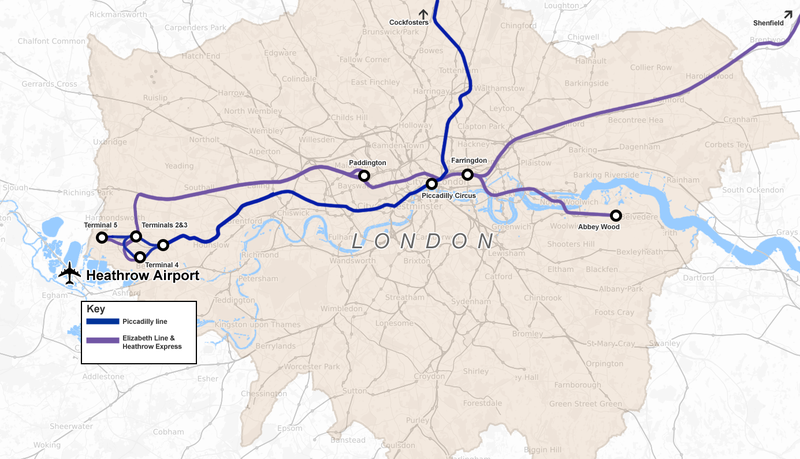
English: Outline map of Tube and rail lines serving Heathrow Airport out of London, UK, showing the Piccadilly line, Heathrow Express and the Elizabeth line (opening late 2019) |
| Date | |
| Source | Own work |
| Author | Cnbrb |
Licensing
[edit]
I, the copyright holder of this work, hereby publish it under the following license:
| This file is made available under the Creative Commons CC0 1.0 Universal Public Domain Dedication. | |
| The person who associated a work with this deed has dedicated the work to the public domain by waiving all of their rights to the work worldwide under copyright law, including all related and neighboring rights, to the extent allowed by law. You can copy, modify, distribute and perform the work, even for commercial purposes, all without asking permission.
|
| Description |
This map was created from OpenStreetMap project data, collected by the community. This map may be incomplete, and may contain errors. Don't rely solely on it for navigation. |
|||
| Date | (see file history) | |||
| Source | openstreetmap.org | |||
| Creator |
OpenStreetMap contributors |
|||
| Permission (Reusing this file) |
OpenStreetMap data is available under the Open Database License (details). Map tiles are licensed under the Creative Commons Attribution-ShareAlike 2.0 license (CC-BY-SA 2.0).
This file is licensed under the Creative Commons Attribution-Share Alike 2.0 Generic license.
|
|||
| Georeferencing | If inappropriate please set warp_status = skip to hide. |
File history
Click on a date/time to view the file as it appeared at that time.
| Date/Time | Thumbnail | Dimensions | User | Comment | |
|---|---|---|---|---|---|
| current | 13:02, 13 September 2018 | | 1,385 × 795 (793 KB) | Cnbrb (talk | contribs) | User created page with UploadWizard |
You cannot overwrite this file.
File usage on Commons
The following 8 pages use this file:
- Airports of London
- London Heathrow Airport
- User:Chumwa/OgreBot/Potential transport maps/2018 September 11-20
- User:Chumwa/OgreBot/Public transport information/2018 September 11-20
- User:Chumwa/OgreBot/Transport Maps/2018 September 11-20
- User:Chumwa/OgreBot/Travel and communication maps/2018 September 11-20
- User:Mattbuck/Railways/2018 September
- Commons:WikiProject Aviation/recent uploads/2018 September 13
File usage on other wikis
The following other wikis use this file:
- Usage on de.wikipedia.org
- Usage on en.wikipedia.org
Metadata
Categories:
- Maps of the Piccadilly line
- Elizabeth line maps
- Public transport at London Heathrow Airport
- Maps of London Heathrow Airport
- Heathrow Express
- Heathrow Terminal 4 railway station
- Heathrow Terminal 5 station
- Heathrow Central railway station
- Heathrow Underground stations
- Heathrow Terminals 2 & 3 tube station
- Heathrow Terminal 4 tube station