File:Greater Iraq.png
Jump to navigation
Jump to search
No higher resolution available.
Greater_Iraq.png (464 × 370 pixels, file size: 17 KB, MIME type: image/png)
Captions
Captions
Fictional map
Accuracy
[edit]
Summary
[edit]
| Description |
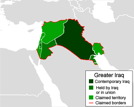
English: Map of a Greater Iraq as envisioned by some Iraqi nationalists. The dark green represents contemporary Iraq. The medium green represents territory both claimed by Iraqi nationalists and held by Iraq such as Kuwait under Iraqi occupation, 1990-1991) or held in union by Iraq such as its federation with Jordan, including Jordanian control over the West Bank during the 1950s. Light green represents territory claimed by Iraqi nationalists that was not held by Iraq. Some Iraqi nationalists have held irredentist claims to the Arab-populated province of Khuzestan in Iran, Kuwait, and a small territory in Saudi Arabia formerly part of the Saudi–Kuwaiti neutral zone as parts of Iraq. (Miller, Robert S. America's Disposable Soldiers: The Real Truth Behind Gulf War Illness. Victoria, British Columbia, Canada: Hikma Books, 2002. Pp. 260.) After gaining independence in 1932, the Iraqi government immediately declared that Kuwait was rightfully a territory of Iraq, as it had been part of an Iraqi territory until the British creation of Kuwait after World War I and thus stated that Kuwait was a British imperialist invention. (Duiker, William J; Spielvogel, Jackson J. World History: From 1500. 5th edition. Belmont, California, USA: Thomson Wadsworth, 2007. Pp. 839.) Iraqi and pan-Arab nationalists during World War II promoted merging the Vichy French mandates of Lebanon and Syria along with the British mandate in Palestine and Transjordan together with Iraq into a single state. (Louis, William Roger. The British Empire in the Middle East, 1945-1951: Arab Nationalism, the United States, and Postwar Imperialism. New York, New York, USA: Oxford University Press. Pp. 313.) |
| Date | |
| Source | Own work |
| Author | R-41 |
Licensing
[edit]
| I, the copyright holder of this work, release this work into the public domain. This applies worldwide. In some countries this may not be legally possible; if so: I grant anyone the right to use this work for any purpose, without any conditions, unless such conditions are required by law. |
File history
Click on a date/time to view the file as it appeared at that time.
| Date/Time | Thumbnail | Dimensions | User | Comment | |
|---|---|---|---|---|---|
| current | 01:38, 18 May 2010 | | 464 × 370 (17 KB) | R-41~commonswiki (talk | contribs) | {{Information |Description={{en|1=Map of a Greater Iraq as envisioned by Iraqi nationalists.}} |Source={{own}} |Author=R-41 |Date=2010-05-17 |Permission= |other_versions= }} Category:Iraq |
You cannot overwrite this file.
File usage on Commons
There are no pages that use this file.
File usage on other wikis
The following other wikis use this file:
- Usage on en.wikipedia.org