File:Earth from Space- The Amazon plume ESA26005378.tiff

Original file (4,625 × 8,182 pixels, file size: 108.29 MB, MIME type: image/tiff)
Captions
Captions
Summary
[edit]| Description |
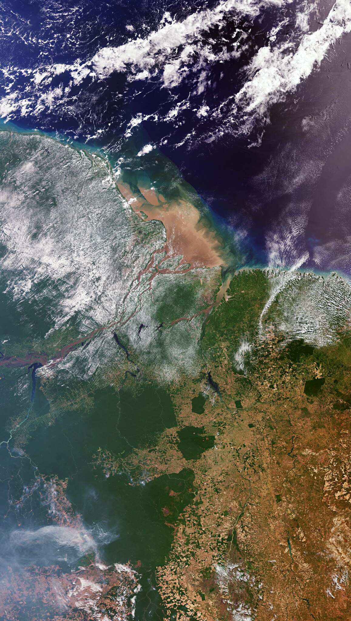
English: The Copernicus Sentinel-3 mission takes us over northern Brazil, where the Amazon River meets the Atlantic Ocean. Zoom in to explore this image at its full resolution or click on the circles to learn more. Originating in the Andes, the Amazon River flows east, traversing six South American countries before reaching the northeast coast of Brazil, where it empties into the Atlantic. The sediment-laden river appears brown as it flows to the open ocean in the upper centre of the image. The coast is surrounded by a muddy-brownish plume of suspended sediment, carried from upstream to the maze of channels constituting the 270-km-wide mouth of the Amazon. Discharge from the Amazon River, the Amazon plume, accounts for around 20% of the global input of freshwater into the ocean from Earth's land surfaces. The Amazon has over 1000 tributaries, some of which are visible as thin, winding lines entering the river from the south, including the Tapajos River to the west and, further downstream, the Xingu River. The dark colour of these sediment-poor tributaries contrasts with the brownish sediment-rich Amazon waters. The Tapajós-Xingu area is an important moist forest ecoregion. However, the Transamazon Highway, discernible as a brown line traversing this area, has spurred urbanisation. The colour of the land varies, ranging from the deep green of dense, untouched vegetation to various tones of brown, highlighting the contrast between the rainforest and sprawling cultivation ̶ the fishbone-like patterns particularly visible along the highway. Light green hues across the image denote agricultural areas, which were once covered by rainforest. The somewhat geometric shapes, which appear dark green and brown, result from forest clear-cutting. Rainforests worldwide are disappearing at an alarming rate, a matter of great concern owing to their pivotal role in the global climate, and their status as habitats for a wide range of plants, animals and insects. With their unique view from space, Earth observation satellites like Copernicus Sentinel-3 are instrumental in highlighting the vulnerability of rainforests by documenting, on a large scale, the extent and damage due to deforestation, particularly in remote regions. |
| Date | 29 March 2024 (upload date) |
| Source | Earth from Space: The Amazon plume |
| Author | European Space Agency |
| Other versions |
|
| Activity | Observing the Earth |
| Mission | Sentinel-3 |
| Set | Earth from Space image collection |
| System | Copernicus |

Licensing
[edit]
|
This image contains data from a satellite in the Copernicus Programme, such as Sentinel-1, Sentinel-2 or Sentinel-3. Attribution is required when using this image.
Attribution: Contains modified Copernicus Sentinel data 2022
The use of Copernicus Sentinel Data is regulated under EU law (Commission Delegated Regulation (EU) No 1159/2013 and Regulation (EU) No 377/2014). Relevant excerpts:
Free access shall be given to GMES dedicated data [...] made available through GMES dissemination platforms [...].
Access to GMES dedicated data [...] shall be given for the purpose of the following use in so far as it is lawful:
GMES dedicated data [...] may be used worldwide without limitations in time.
GMES dedicated data and GMES service information are provided to users without any express or implied warranty, including as regards quality and suitability for any purpose. |
This media was created by the European Space Agency (ESA).
Where expressly so stated, images or videos are covered by the Creative Commons Attribution-ShareAlike 3.0 IGO (CC BY-SA 3.0 IGO) licence, ESA being an Intergovernmental Organisation (IGO), as defined by the CC BY-SA 3.0 IGO licence. The user is allowed under the terms and conditions of the CC BY-SA 3.0 IGO license to Reproduce, Distribute and Publicly Perform the ESA images and videos released under CC BY-SA 3.0 IGO licence and the Adaptations thereof, without further explicit permission being necessary, for as long as the user complies with the conditions and restrictions set forth in the CC BY-SA 3.0 IGO licence, these including that:
See the ESA Creative Commons copyright notice for complete information, and this article for additional details.
|
 | |
This file is licensed under the Creative Commons Attribution-ShareAlike 3.0 IGO license. Attribution: ESA, CC BY-SA IGO 3.0
| ||
File history
Click on a date/time to view the file as it appeared at that time.
| Date/Time | Thumbnail | Dimensions | User | Comment | |
|---|---|---|---|---|---|
| current | 09:12, 29 March 2024 |  | 4,625 × 8,182 (108.29 MB) | OptimusPrimeBot (talk | contribs) | #Spacemedia - Upload of https://esamultimedia.esa.int/img/2024/03/Amazon_mouth_S3_20220816_ML.tif via Commons:Spacemedia |
You cannot overwrite this file.
File usage on Commons
The following page uses this file: