File:Divisiones administrativas de la Confederación Perú-Boliviana.svg
Jump to navigation
Jump to search

Size of this PNG preview of this SVG file: 514 × 599 pixels. Other resolutions: 206 × 240 pixels | 412 × 480 pixels | 659 × 768 pixels | 878 × 1,024 pixels | 1,757 × 2,048 pixels | 1,230 × 1,434 pixels.
Original file (SVG file, nominally 1,230 × 1,434 pixels, file size: 844 KB)
Captions
Captions
Add a one-line explanation of what this file represents
Summary
[edit]
| Description |
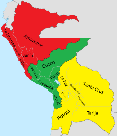
Español: Mapa de la Confederación Perú-Boliviana. Incluye todos los territorios en disputa (Límite con Ecuador, Colombia y Brasil en el Amazonas, el Corredor de Atacama con Chile, el Chaco con Paraguay y Tarija con Argentina, además de la Puna de Atacama).
English: Map of the Peru-Bolivian Confederation. It includes all the disputed territories (The border with Ecuador, Colombia and Brazil in the Amazon, the Atacama Corridor with Chile, the Chacho with Paraguay and Tarija with Argentina, in addition to the Puna de Atacama). |
| Date | |
| Source |
Own work Coastline extracted from: File:Ecuador location map.svg & File:Chile location map.svg by NordNordWest & File:Peru location map.svg by Spischot |
| Author |
Janitoalevic Coastline extracted from: File:Ecuador location map.svg & File:Chile location map.svg by NordNordWest & File:Peru location map.svg by Spischot |
| Other versions | File:Divisiones administrativas de la Confederación Perú-Boliviana.svg |
Licensing
[edit]

|
Permission is granted to copy, distribute and/or modify this document under the terms of the GNU Free Documentation License, Version 1.2 or any later version published by the Free Software Foundation; with no Invariant Sections, no Front-Cover Texts, and no Back-Cover Texts. A copy of the license is included in the section entitled GNU Free Documentation License. |
File history
Click on a date/time to view the file as it appeared at that time.
| Date/Time | Thumbnail | Dimensions | User | Comment | |
|---|---|---|---|---|---|
| current | 02:39, 22 July 2020 | | 1,230 × 1,434 (844 KB) | Janitoalevic (talk | contribs) | Detalles |
| 02:19, 22 July 2020 |  | 1,230 × 1,434 (862 KB) | Janitoalevic (talk | contribs) | + Huaylas & Oruro. * Límites mejorados. | |
| 00:24, 1 December 2019 |  | 1,230 × 1,434 (817 KB) | Janitoalevic (talk | contribs) | . | |
| 00:20, 1 December 2019 |  | 1,230 × 1,434 (816 KB) | Janitoalevic (talk | contribs) | Added Litoral and Tarija. | |
| 00:20, 1 December 2019 |  | 1,230 × 1,434 (800 KB) | Janitoalevic (talk | contribs) | . | |
| 01:11, 28 August 2019 |  | 1,230 × 1,434 (816 KB) | Janitoalevic (talk | contribs) | fixed coastline | |
| 00:00, 28 August 2019 |  | 1,230 × 1,434 (816 KB) | Janitoalevic (talk | contribs) | User created page with UploadWizard |
You cannot overwrite this file.
File usage on Commons
The following 4 pages use this file:
File usage on other wikis
The following other wikis use this file:
- Usage on de.wikipedia.org
- Usage on en.wikipedia.org
- Usage on es.wikipedia.org
- Usage on ja.wikipedia.org
- Usage on ru.wikipedia.org
- Usage on tr.wikipedia.org