File:Deutsche Metropolregionen.svg
From Wikimedia Commons, the free media repository
Jump to navigation
Jump to search

Size of this PNG preview of this SVG file: 452 × 599 pixels. Other resolutions: 181 × 240 pixels | 362 × 480 pixels | 579 × 768 pixels | 772 × 1,024 pixels | 1,544 × 2,048 pixels | 754 × 1,000 pixels.
Original file (SVG file, nominally 754 × 1,000 pixels, file size: 692 KB)
File information
Structured data
Captions
Captions
Add a one-line explanation of what this file represents

|
This file has been superseded by Karte Metropolregionen.svg. It is recommended to use the other file. Please note that deleting superseded images requires consent.
|

|
| DescriptionDeutsche Metropolregionen.svg |
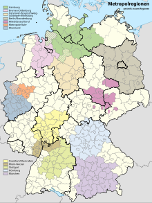
English: Map of the 11 metropolitan regions in Germany:
Deutsch: Manche Regionen sind klar definiert durch Kooperation der verschiedenen Landkreise und Gemeinden. Andere Regionen haben keine festen Institutionen und sind daher auch nicht eindeutig abzugrenzen. |
|||
| Date | ||||
| Source | File:Landkreise, Kreise und kreisfreie Städte in Deutschland.svg, Bericht des IKM (Verband der Metropolregionen), File:Deutschland Metropolregionen.png, w:de:Metropolregion, Artikel der einzelnen Regionen in der deutschen Wikipedia | |||
| Author | w:de:Benutzer:Bobi211 | |||
| Permission (Reusing this file) |
|
|||
| Other versions |
   |
File history
Click on a date/time to view the file as it appeared at that time.
| Date/Time | Thumbnail | Dimensions | User | Comment | |
|---|---|---|---|---|---|
| current | 23:59, 4 February 2010 |  | 754 × 1,000 (692 KB) | Bobi211 (talk | contribs) | ohne kreisfreie Städte, Beschriftung direkt im Bild, nicht so grelle Farben |
| 00:18, 2 January 2010 |  | 754 × 1,000 (713 KB) | Bobi211 (talk | contribs) | white background in germany, height = 1000px | |
| 15:15, 1 January 2010 |  | 9,463 × 12,526 (686 KB) | Bobi211 (talk | contribs) | Nach dem http://www.m-r-n.com/fileadmin/ikm/IKM-Veroeffentlichungen/IKM_MORO_Bericht_2007.pdf IKM-Bericht aktualisiert. Landkreisgrenzen außerhalb der Metropolregionen entfernt. | |
| 22:03, 31 December 2009 |  | 9,463 × 12,526 (957 KB) | Bobi211 (talk | contribs) | {{Information |Description= Map of the 11 metropolitan regions in Germany: *#Berlin/Brandenburg *#Bremen-Oldenburg *#Frankfurt/Rhein-Main *#Hamburg *#Hannover-Braunschweig-Göttingen-Wolfsburg *#München *#Nürnberg *#Rhein-Neckar *#Rhein-Ruhr *#Sachsend |
You cannot overwrite this file.
File usage on Commons
The following page uses this file:
File usage on other wikis
The following other wikis use this file:
- Usage on de.wikipedia.org