File:Danzig-Westpreussen.png
From Wikimedia Commons, the free media repository
Jump to navigation
Jump to search

Size of this preview: 675 × 599 pixels. Other resolutions: 270 × 240 pixels | 541 × 480 pixels | 865 × 768 pixels | 1,154 × 1,024 pixels | 1,772 × 1,573 pixels.
Original file (1,772 × 1,573 pixels, file size: 797 KB, MIME type: image/png)
File information
Structured data
Captions
Captions
Add a one-line explanation of what this file represents
Summary
[edit]| DescriptionDanzig-Westpreussen.png |
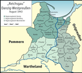
English: Map of „Reichsgau Danzig-Westpreussen“, 1943
Deutsch: Karte des „Reichsgaus Danzig-Westpreussen“, 1943 |
| Date | |
| Source | Own work |
| Author | User:ziegelbrenner |

|
This map has been made or improved in the German Kartenwerkstatt (Map Lab). You can propose maps to improve as well.
azərbaycanca ∙ čeština ∙ Deutsch ∙ Deutsch (Sie-Form) ∙ English ∙ español ∙ français ∙ italiano ∙ latviešu ∙ magyar ∙ Nederlands ∙ Plattdüütsch ∙ polski ∙ português ∙ română ∙ sicilianu ∙ slovenščina ∙ suomi ∙ oʻzbekcha / ўзбекча/ ∙ македонски ∙ русский ∙ ქართული ∙ հայերեն ∙ বাংলা ∙ ไทย ∙ +/−
|
Licensing
[edit]| Public domainPublic domainfalsefalse |
| I, the copyright holder of this work, release this work into the public domain. This applies worldwide. In some countries this may not be legally possible; if so: I grant anyone the right to use this work for any purpose, without any conditions, unless such conditions are required by law. |
File history
Click on a date/time to view the file as it appeared at that time.
| Date/Time | Thumbnail | Dimensions | User | Comment | |
|---|---|---|---|---|---|
| current | 23:48, 13 October 2016 |  | 1,772 × 1,573 (797 KB) | PDD (talk | contribs) | corrected "Beren" to "Berent" |
| 10:08, 23 April 2010 |  | 1,772 × 1,573 (750 KB) | Ziegelbrenner (talk | contribs) | 2010-04-23 | |
| 17:24, 27 January 2009 |  | 1,772 × 1,575 (738 KB) | Ziegelbrenner (talk | contribs) | {{Information |Description= |Source= |Date= |Author= |Permission= |other_versions= }} | |
| 14:02, 22 January 2009 |  | 1,595 × 1,417 (800 KB) | Ziegelbrenner (talk | contribs) | {{Information |Description= |Source= |Date= |Author= |Permission= |other_versions= }} | |
| 15:38, 20 January 2009 |  | 1,594 × 1,417 (605 KB) | Ziegelbrenner (talk | contribs) | {{Information |Description= |Source= |Date= |Author= |Permission= |other_versions= }} | |
| 14:35, 20 January 2009 |  | 1,594 × 1,417 (601 KB) | Ziegelbrenner (talk | contribs) | {{Information |Description= |Source= |Date= |Author= |Permission= |other_versions= }} | |
| 14:28, 20 January 2009 |  | 1,594 × 1,417 (602 KB) | Ziegelbrenner (talk | contribs) | {{Information |Description={{en|1=Map of "Reichsgau Danzig-Westpreussen", 1943}} {{de|1=Karte des "Reichsgaus Danzig-Westpreussen", 1943}} |Source=Eigenes Werk (own work) |Author=Kgberger |Date=2009-01-20 |Permission= |other_versions=unb |
You cannot overwrite this file.
File usage on Commons
The following 4 pages use this file:
File usage on other wikis
The following other wikis use this file:
- Usage on ar.wikipedia.org
- Usage on ca.wikipedia.org
- Usage on de.wikipedia.org
- Provinz Westpreußen
- Kreis Marienwerder
- Landkreis Elbing
- Landkreis Danzig
- Landkreis Großes Werder
- Kreis Briesen
- Landkreis Graudenz
- Landkreis Rippin (Westpr.)
- Kreis Strasburg in Westpreußen
- Kreis Löbau (Westpreußen)
- Kreis Kulm
- Kreis Schwetz
- Landkreis Thorn
- Landkreis Zempelburg
- Landkreis Bromberg
- Kreis Tuchel
- Kreis Berent
- Kreis Karthaus
- Kreis Dirschau
- Kreis Preußisch Stargard
- Kreis Neustadt in Westpreußen
- Danzig
- Landkreis Leipe (Westpr.)
- Kreis Wirsitz
- Wikipedia:Kartenwerkstatt/Archiv/2009-01
- Benutzer:Agp/Meine Bilder
- Diskussion:Regierungsbezirk Westpreußen
- Benutzer:Ziegelbrenner/Meine Bilder auf Commons
- Regierungsbezirk Marienwerder (Danzig-Westpreußen)
- Regierungsbezirk Danzig (Danzig-Westpreußen)
- Regierungsbezirk Bromberg (Danzig-Westpreußen)
- Usage on en.wikipedia.org
- Usage on eu.wikipedia.org
- Usage on fr.wikipedia.org
View more global usage of this file.
Metadata
This file contains additional information such as Exif metadata which may have been added by the digital camera, scanner, or software program used to create or digitize it. If the file has been modified from its original state, some details such as the timestamp may not fully reflect those of the original file. The timestamp is only as accurate as the clock in the camera, and it may be completely wrong.
| File change date and time | 23:47, 13 October 2016 |
|---|---|
| Horizontal resolution | 118.1 dpc |
| Vertical resolution | 118.1 dpc |