File:Danubemap-ar.png
From Wikimedia Commons, the free media repository
Jump to navigation
Jump to search
Danubemap-ar.png (747 × 480 pixels, file size: 589 KB, MIME type: image/png)
File information
Structured data
Captions
Captions
Add a one-line explanation of what this file represents
Summary
[edit]This image was created with Paint.net.
| DescriptionDanubemap-ar.png |
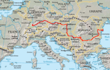
العربية: خريطة تظهر مسار نهر الدانوب في قارة أوروبا.
English: Map showing the flow of the Danube River. Uses the map of Europe from the CIA World Factbook. |
|||||||||||||||||
| Date | ||||||||||||||||||
| Source | Derived from this file | |||||||||||||||||
| Author |
creator QS:P170,Q81411358 |
|||||||||||||||||
| Other versions |
 |
|||||||||||||||||
| This is a retouched picture, which means that it has been digitally altered from its original version. Modifications: Translated to Arabic - عُرّبت. The original can be viewed here: Danubemap.png:
|
Licensing
[edit]I, the copyright holder of this work, hereby publish it under the following license:
This file is licensed under the Creative Commons Attribution-Share Alike 4.0 International license.
- You are free:
- to share – to copy, distribute and transmit the work
- to remix – to adapt the work
- Under the following conditions:
- attribution – You must give appropriate credit, provide a link to the license, and indicate if changes were made. You may do so in any reasonable manner, but not in any way that suggests the licensor endorses you or your use.
- share alike – If you remix, transform, or build upon the material, you must distribute your contributions under the same or compatible license as the original.
File history
Click on a date/time to view the file as it appeared at that time.
| Date/Time | Thumbnail | Dimensions | User | Comment | |
|---|---|---|---|---|---|
| current | 22:19, 28 December 2019 |  | 747 × 480 (589 KB) | Michel Bakni (talk | contribs) | User created page with UploadWizard |
You cannot overwrite this file.
File usage on Commons
There are no pages that use this file.
File usage on other wikis
The following other wikis use this file:
- Usage on ar.wikipedia.org
- فيينا
- بلغراد
- براتيسلافا
- بودابست
- دانوب
- سافا
- مورافا
- معركة فارنا
- ريغنسبورغ
- روسه
- أولم
- إنغولشتات
- معركة نيقوبوليس
- نوفي ساد
- لينتس
- غالاتس
- برايلا
- تولتشيا
- أولت (نهر)
- جيو
- أرجيش (نهر)
- نهر بروت
- نهر فاه
- تيسا
- إن (نهر)
- درافا
- جغرافيا ألمانيا
- أطة قلعة
- إيزار
- جغرافيا كرواتيا
- قالب:دانوب
- نهر إسكر
- جغرافيا أوكرانيا
- جغرافيا بلغاريا
- نهر تيميش
- نهر هرون
- باساو
- نهر ليخ
- جزيرة مارغريت
- مستخدم:Michel Bakni
- جيور
- بوتينشتاين (بافاريا العليا)
- جغرافيا رومانيا
- نهر سيرت
- مستخدم:Michel Bakni/صور
- جغرافيا المجر
- إلر
- ينترة (نهر)
- نهر أسام
Metadata
This file contains additional information such as Exif metadata which may have been added by the digital camera, scanner, or software program used to create or digitize it. If the file has been modified from its original state, some details such as the timestamp may not fully reflect those of the original file. The timestamp is only as accurate as the clock in the camera, and it may be completely wrong.
| Horizontal resolution | 28.35 dpc |
|---|---|
| Vertical resolution | 28.35 dpc |

