File:Beroun District 2008 names BE CZ.png
From Wikimedia Commons, the free media repository
Jump to navigation
Jump to search

Size of this preview: 625 × 599 pixels. Other resolutions: 250 × 240 pixels | 501 × 480 pixels | 976 × 936 pixels.
Original file (976 × 936 pixels, file size: 104 KB, MIME type: image/png)
File information
Structured data
Captions
Captions
Add a one-line explanation of what this file represents

|
This locator map image could be re-created using vector graphics as an SVG file. This has several advantages; see Commons:Media for cleanup for more information. If an SVG form of this image is available, please upload it and afterwards replace this template with
{{vector version available|new image name}}.
It is recommended to name the SVG file “Beroun District 2008 names BE CZ.svg”—then the template Vector version available (or Vva) does not need the new image name parameter. |
| DescriptionBeroun District 2008 names BE CZ.png |
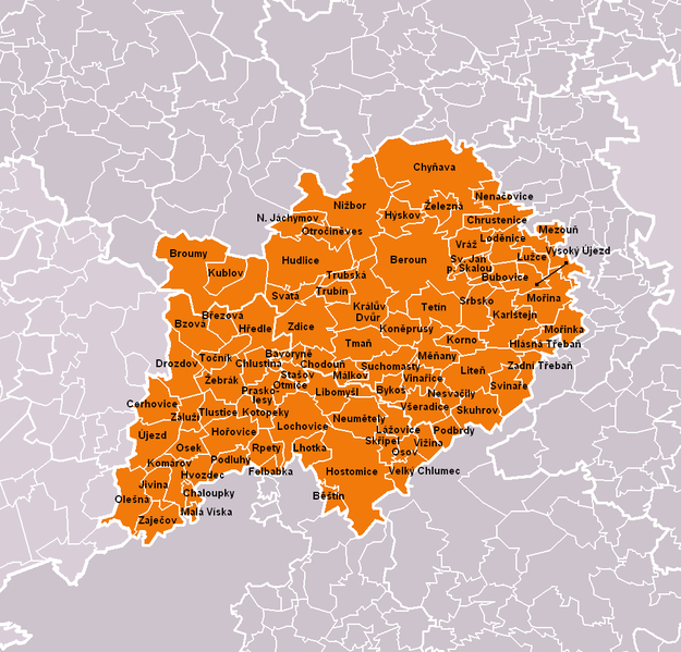
Čeština: Obce okresu Beroun dle stavu platného k roku 2008 (85 obcí). Bílé linie o různé tloušťce představují hranice obcí, správních obvodů, okresů a krajů.
English: Municipalities of Beroun District as of 2008 (85 municipalities in total). White lines of variable thickness show boundaries of municipalities, administrative areas, districts and regions. |
| Date | |
| Source | Self made, based on File:Beroun District 2008 BE CZ.png |
| Author | User:Miaow Miaow |
| Permission (Reusing this file) |
PD-self |
| Other versions |
|
Licensing
[edit]| Public domainPublic domainfalsefalse |
| I, the copyright holder of this work, release this work into the public domain. This applies worldwide. In some countries this may not be legally possible; if so: I grant anyone the right to use this work for any purpose, without any conditions, unless such conditions are required by law. |
File history
Click on a date/time to view the file as it appeared at that time.
| Date/Time | Thumbnail | Dimensions | User | Comment | |
|---|---|---|---|---|---|
| current | 23:53, 31 January 2009 |  | 976 × 936 (104 KB) | Miaow Miaow (talk | contribs) | {{Information |Description={{cs|Obce '''okresu Beroun''' dle stavu platného k roku 2008 (85 obcí). Bílé linie o různé tloušťce představují hranice obcí, správních obvodů, okresů a krajů.}} {{en|Municipalities of '''[[: |
You cannot overwrite this file.
File usage on Commons
The following 84 pages use this file:
- Top 200 locator map images that should use vector graphics
- File:Bavoryne BE CZ.png
- File:Beroun BE CZ.png
- File:Bestin BE CZ.png
- File:Brezova BE CZ.png
- File:Broumy BE CZ.png
- File:Bubovice BE CZ.png
- File:Bykos BE CZ.png
- File:Bzova BE CZ.png
- File:Cerhovice BE CZ.png
- File:Chaloupky BE CZ.png
- File:Chlustina BE CZ.png
- File:Chodoun BE CZ.png
- File:Chrustenice BE CZ.png
- File:Chynava BE CZ.png
- File:Drozdov BE CZ.png
- File:Felbabka BE CZ.png
- File:Hlasna Treban BE CZ.png
- File:Horovice BE CZ.png
- File:Hostomice BE CZ.png
- File:Hredle BE CZ.png
- File:Hudlice BE CZ.png
- File:Hvozdec BE CZ.png
- File:Hyskov BE CZ.png
- File:Jivina BE CZ.png
- File:Karlstejn BE CZ.png
- File:Komárov BE CZ.png
- File:Koneprusy BE CZ.png
- File:Korno BE CZ.png
- File:Kotopeky BE CZ.png
- File:Kraluv Dvur BE CZ.png
- File:Kublov BE CZ.png
- File:Lazovice BE CZ.png
- File:Lhotka BE CZ.png
- File:Libomysl BE CZ.png
- File:Liten BE CZ.png
- File:Lochovice BE CZ.png
- File:Lodenice BE CZ.png
- File:Luzce BE CZ.png
- File:Mala Viska BE CZ.png
- File:Malkov BE CZ.png
- File:Menany BE CZ.png
- File:Mezoun BE CZ.png
- File:Morina BE CZ.png
- File:Morinka BE CZ.png
- File:Nenacovice BE CZ.png
- File:Nesvacily BE CZ.png
- File:Neumetely BE CZ.png
- File:Novy Jachymov BE CZ.png
- File:Olesna BE CZ.png
- File:Osek BE CZ.png
- File:Osov BE CZ.png
- File:Otmice BE CZ.png
- File:Otrocineves BE CZ.png
- File:Podbrdy BE CZ.png
- File:Podluhy BE CZ.png
- File:Praskolesy BE CZ.png
- File:Rpety BE CZ.png
- File:Skripel BE CZ.png
- File:Skuhrov BE CZ.png
- File:Srbsko BE CZ.png
- File:Stasov BE CZ.png
- File:Suchomasty BE CZ.png
- File:Svata BE CZ.png
- File:Svaty Jan pod Skalou BE CZ.png
- File:Svinare BE CZ.png
- File:Tetin BE CZ.png
- File:Tlustice BE CZ.png
- File:Tman BE CZ.png
- File:Tocnik BE CZ.png
- File:Trubin BE CZ.png
- File:Trubska BE CZ.png
- File:Ujezd BE CZ.png
- File:Velky Chlumec BE CZ.png
- File:Vinarice BE CZ.png
- File:Vizina BE CZ.png
- File:Vraz BE CZ.png
- File:Vseradice BE CZ.png
- File:Vysoky Ujezd BE CZ.png
- File:Zadni Treban BE CZ.png
- File:Zajecov BE CZ.png
- File:Zaluzi BE CZ.png
- File:Zdice BE CZ.png
- File:Zelezna BE CZ.png
File usage on other wikis
The following other wikis use this file:
- Usage on azb.wikipedia.org
- Usage on bg.wikipedia.org
- Usage on ca.wikipedia.org
- Usage on cs.wikipedia.org
- Usage on de.wikipedia.org
- Usage on en.wikipedia.org
- Usage on eo.wikipedia.org
- Usage on fa.wikipedia.org
- Usage on frr.wikipedia.org
- Usage on hu.wikipedia.org
- Usage on ka.wikipedia.org
- Usage on ko.wikipedia.org
- Usage on ms.wikipedia.org
- Usage on nl.wikipedia.org
- Usage on pl.wikipedia.org
- Usage on pnb.wikipedia.org
- Usage on pt.wikipedia.org
- Beroun (distrito)
- Beroun
- Predefinição:Distrito de Beroun
- Hořovice
- Hostomice (Boêmia Central)
- Králův Dvůr
- Zdice
- Žebrák
- Cerhovice
- Karlštejn
- Komárov (Boêmia Central)
- Liteň
- Bavoryně
- Běštín
- Broumy
- Březová (Boêmia Central)
- Bubovice
- Bykoš
- Bzová
- Chaloupky
- Chlustina
- Chodouň
- Chrustenice
- Chyňava
- Drozdov (Boêmia Central)
- Felbabka
- Hlásná Třebaň
- Hředle (Beroun)
- Hudlice
- Hvozdec (Boêmia Central)
- Hýskov
- Jivina (Beroun)
- Koněprusy
- Korno
View more global usage of this file.


