File:Basin of Mexico 1519 map-fr.svg
Jump to navigation
Jump to search

Size of this PNG preview of this SVG file: 449 × 599 pixels. Other resolutions: 180 × 240 pixels | 360 × 480 pixels | 576 × 768 pixels | 768 × 1,024 pixels | 1,536 × 2,048 pixels | 1,412 × 1,883 pixels.
Original file (SVG file, nominally 1,412 × 1,883 pixels, file size: 528 KB)
Captions
Captions
Add a one-line explanation of what this file represents
Summary
[edit]| Description |
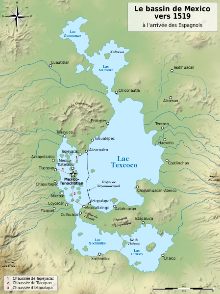
English: Map of the basin of Mexico circa 1519, at the arrival of the Spanish.
Español: Mapa de la cuenca de México acerca 1519, a la llegada de los españoles
Français : Carte du bassin de Mexico vers 1519, à l'arrivée des Espagnols. |
| Date | (UTC) |
| Source |
|
| Author |
|
| Other versions |
[]
|
| SVG development |


| Camera location | | View this and other nearby images on: OpenStreetMap |
|---|
Licensing
[edit]
I, the copyright holder of this work, hereby publish it under the following licenses:

|
Permission is granted to copy, distribute and/or modify this document under the terms of the GNU Free Documentation License, Version 1.2 or any later version published by the Free Software Foundation; with no Invariant Sections, no Front-Cover Texts, and no Back-Cover Texts. A copy of the license is included in the section entitled GNU Free Documentation License. |
This file is licensed under the Creative Commons Attribution-Share Alike 4.0 International, 3.0 Unported, 2.5 Generic, 2.0 Generic and 1.0 Generic license.
- You are free:
- to share – to copy, distribute and transmit the work
- to remix – to adapt the work
- Under the following conditions:
- attribution – You must give appropriate credit, provide a link to the license, and indicate if changes were made. You may do so in any reasonable manner, but not in any way that suggests the licensor endorses you or your use.
- share alike – If you remix, transform, or build upon the material, you must distribute your contributions under the same or compatible license as the original.
You may select the license of your choice.
Original upload log
[edit]
This image is a derivative work of the following images:
- File:Lago_de_Texcoco-posclásico.png licensed with PD-self, PD-self/fr
- 2006-09-19T01:46:06Z Yavidaxiu 1412x1644 (344123 Bytes) {{Information |Description={{es|Mapa de la cuenca de México a la llegada de los españoles}} |Source=Trabajo propio |Date=18 de septiembre de 2006 |Author=Yavidaxiu |Permission={{PD-self}} |other_versions= }} [[Category:Map
- File:Valley_of_Mexico_c.1519-fr.svg licensed with Cc-by-sa-2.5,2.0,1.0, Cc-by-sa-3.0-migrated, GFDL
- 2007-09-11T14:00:14Z Historicair 731x849 (270643 Bytes)
- 2007-09-11T13:51:30Z Historicair 731x849 (272818 Bytes) {{Information |Description={{fr|Les environs de Tenochtitlan vers 1519}} {{en|Valley of Mexico circa 1519}} |Source=Own work |Date=11/09/2007 |Author=~~~~ |Permission={{self2|GFDL|cc-by-sa-2.5,2.0,1.0}} |other_versions= }} {{
Uploaded with derivativeFX
File history
Click on a date/time to view the file as it appeared at that time.
| Date/Time | Thumbnail | Dimensions | User | Comment | |
|---|---|---|---|---|---|
| current | 20:29, 28 January 2021 | | 1,412 × 1,883 (528 KB) | Sémhur (talk | contribs) | Huexotla <=> Coatlinchán |
| 18:21, 17 July 2013 |  | 1,412 × 1,883 (525 KB) | Citypeek (talk | contribs) | Enlargement of legenda in upper-right corner. | |
| 18:17, 17 July 2013 |  | 1,412 × 1,883 (533 KB) | Citypeek (talk | contribs) | Corrected two errors. Valid SVG now. | |
| 18:38, 8 February 2010 |  | 1,412 × 1,883 (533 KB) | Sémhur (talk | contribs) | un accent en trop | |
| 18:27, 8 February 2010 |  | 1,412 × 1,883 (532 KB) | Sémhur (talk | contribs) | + relief and some improvements | |
| 09:27, 31 January 2010 |  | 1,412 × 1,645 (99 KB) | Sémhur (talk | contribs) | == {{int:filedesc}} == {{Information |Description= {{en|Map of the basin of Mexico circa 1519, at the arrival of the Spanish.}} {{es|Mapa de la cuenca de México acerca 1519, a la llegada de los españoles}} {{fr|Carte du bassin de Mexico vers 1519, à l |
You cannot overwrite this file.
File usage on Commons
The following 7 pages use this file:
- User:Daniel Mietchen/Category:Images used by media organizations but violating license terms
- User:Magog the Ogre/Multilingual legend/2021 January 21-31
- File:Basin of Mexico 1519 map-en.svg
- File:Basin of Mexico 1519 map-es.svg
- File:Basin of Mexico 1519 map-fr.svg
- File:Basin of Mexico 1519 map-zh-cn.svg
- Template:Other versions/Basin of Mexico 1519 map
File usage on other wikis
The following other wikis use this file:
- Usage on an.wikipedia.org
- Usage on eu.wikipedia.org
- Usage on fr.wikipedia.org