File:Banat backa baranja 01 map.png
Jump to navigation
Jump to search

Size of this preview: 658 × 600 pixels. Other resolutions: 263 × 240 pixels | 527 × 480 pixels | 843 × 768 pixels | 1,198 × 1,092 pixels.
Original file (1,198 × 1,092 pixels, file size: 107 KB, MIME type: image/png)
Captions
Captions
Add a one-line explanation of what this file represents
Summary
[edit]
| Description |
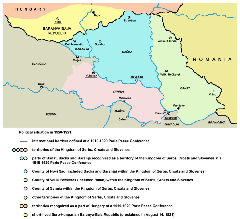
English: historical map of Banat, Bačka, Baranja and Syrmia within the Kingdom of Serbs, Croats and Slovenes in 1920-1921 and short-lived Baranya-Baja Republic in 1921
Српски / srpski: историјска мапа Баната, Бачке, Барање и Срема у саставу Краљевине Срба, Хрвата и Словенаца 1920-1921. године и краткотрајне Барањско-Бајске републике 1921. године |
| Date | 9 February 2009 (original upload date) |
| Source | No machine-readable source provided. Own work assumed (based on copyright claims). |
| Author | No machine-readable author provided. PANONIAN assumed (based on copyright claims). |
References
[edit]
- Istorijski atlas, Zavod za udžbenike i nastavna sredstva - Zavod za kartografiju "Geokarta", Beograd, 1999.
- Dimitrije Boarov, Politička istorija Vojvodine, Novi Sad, 2001.
- Peter Rokai - Zoltan Đere - Tibor Pal - Aleksandar Kasaš, Istorija Mađara, Beograd, 2002.
Licensing
[edit]
self made map by user:PANONIAN
| I, the copyright holder of this work, release this work into the public domain. This applies worldwide. In some countries this may not be legally possible; if so: I grant anyone the right to use this work for any purpose, without any conditions, unless such conditions are required by law. |
File history
Click on a date/time to view the file as it appeared at that time.
| Date/Time | Thumbnail | Dimensions | User | Comment | |
|---|---|---|---|---|---|
| current | 22:29, 15 May 2014 | | 1,198 × 1,092 (107 KB) | WikiEditor2004 (talk | contribs) | aesthetics |
| 16:51, 8 December 2010 |  | 1,194 × 1,092 (107 KB) | WikiEditor2004 (talk | contribs) | aesthetical correction | |
| 14:10, 5 July 2009 |  | 1,194 × 1,092 (107 KB) | WikiEditor2004 (talk | contribs) | ||
| 23:35, 9 February 2009 |  | 887 × 621 (39 KB) | WikiEditor2004 (talk | contribs) | historical map of Banat, Bačka and Baranja (self made) {{PD-self}} Category:Maps of the history of Vojvodina Category:Maps of the history of Serbia |
You cannot overwrite this file.
File usage on Commons
The following page uses this file:
File usage on other wikis
The following other wikis use this file:
- Usage on el.wikipedia.org
- Usage on en.wikipedia.org
- Usage on gl.wikipedia.org
- Usage on hr.wikipedia.org
- Usage on mk.wikipedia.org
- Usage on sh.wikipedia.org
- Usage on th.wikipedia.org
- Usage on tr.wikipedia.org
Categories:
- Banat, Bačka and Baranja
- Serbian-Hungarian Baranya-Baja Republic
- Maps of the history of Vojvodina
- Maps of the history of Serbia in modern times
- Maps of the history of Baranja
- Maps of the history of Bačka
- Maps of the history of Banat
- Maps of the history of Syrmia
- Maps of administrative units of Yugoslavia
- Maps of the history of modern Croatia