File:BSEC Map.png
From Wikimedia Commons, the free media repository
Jump to navigation
Jump to search

Size of this preview: 800 × 370 pixels. Other resolutions: 320 × 148 pixels | 640 × 296 pixels | 1,357 × 628 pixels.
Original file (1,357 × 628 pixels, file size: 40 KB, MIME type: image/png)
File information
Structured data
Captions
Captions
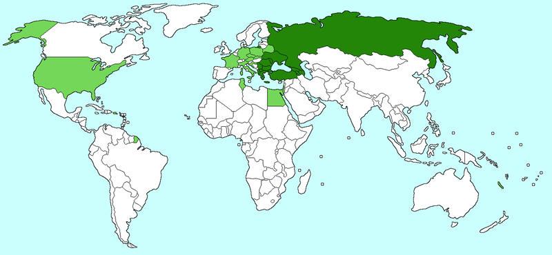
Karadeniz Ekonomik İş Birliği Örgütü (ve gözlemci devletler)
Karadeniz Ekonomik İşbirliği (ve gözlemci devletler)

|
File:Black Sea Economic Cooperation.svg is a vector version of this file. It should be used in place of this PNG file when not inferior.
File:BSEC Map.png → File:Black Sea Economic Cooperation.svg
For more information, see Help:SVG.
|
Any autoconfirmed user can overwrite this file from the same source. Please ensure that overwrites comply with the guideline.
Summary
[edit]| DescriptionBSEC Map.png |
English: Map of the Black Sea Economic Cooperation (and observer states). Created by Aris Katsaris modifying Image:BlankMap-World-v2.png. Aris Katsaris 22:02, 15 March 2006 (UTC) |
| Source | No machine-readable source provided. Own work assumed (based on copyright claims). |
| Author | No machine-readable author provided. Aris Katsaris assumed (based on copyright claims). |
Licensing
[edit]I, the copyright holder of this work, hereby publish it under the following licenses:

|
Permission is granted to copy, distribute and/or modify this document under the terms of the GNU Free Documentation License, Version 1.2 or any later version published by the Free Software Foundation; with no Invariant Sections, no Front-Cover Texts, and no Back-Cover Texts. A copy of the license is included in the section entitled GNU Free Documentation License.http://www.gnu.org/copyleft/fdl.htmlGFDLGNU Free Documentation Licensetruetrue |
| This file is licensed under the Creative Commons Attribution-Share Alike 3.0 Unported license. | ||
| ||
| This licensing tag was added to this file as part of the GFDL licensing update.http://creativecommons.org/licenses/by-sa/3.0/CC BY-SA 3.0Creative Commons Attribution-Share Alike 3.0truetrue |
This file is licensed under the Creative Commons Attribution 2.5 Generic license.
- You are free:
- to share – to copy, distribute and transmit the work
- to remix – to adapt the work
- Under the following conditions:
- attribution – You must give appropriate credit, provide a link to the license, and indicate if changes were made. You may do so in any reasonable manner, but not in any way that suggests the licensor endorses you or your use.
You may select the license of your choice.
File history
Click on a date/time to view the file as it appeared at that time.
| Date/Time | Thumbnail | Dimensions | User | Comment | |
|---|---|---|---|---|---|
| current | 01:50, 6 April 2021 |  | 1,357 × 628 (40 KB) | SilentResident (talk | contribs) | Per official website, North Macedonia became member. Also changing the purple ocean color to cyan to bring it closer to the Wikipedia's map coloring standards |
| 10:21, 1 December 2013 |  | 1,357 × 628 (63 KB) | Giorgi Balakhadze (talk | contribs) | Reverted to version as of 19:59, 1 June 2008 | |
| 11:26, 18 August 2010 |  | 1,425 × 625 (49 KB) | Коваленко Кирилл (talk | contribs) | _ | |
| 08:50, 1 July 2010 |  | 2,753 × 1,400 (154 KB) | Коваленко Кирилл (talk | contribs) | . | |
| 19:59, 1 June 2008 |  | 1,357 × 628 (63 KB) | Mocu (talk | contribs) | Added Austria and Egypt | |
| 22:14, 22 February 2008 |  | 1,357 × 628 (63 KB) | Hoshie (talk | contribs) | added Montenegro | |
| 22:02, 15 March 2006 |  | 1,357 × 628 (52 KB) | Aris Katsaris (talk | contribs) | Map of the Black Sea Economic Cooperation (and observer states). Created by ~~~ modifying Image:BlankMap-World-v2.png. ~~~~ Category:Supranational maps |
You cannot overwrite this file.
File usage on Commons
The following page uses this file:
File usage on other wikis
The following other wikis use this file:
- Usage on ar.wikipedia.org
- Usage on ast.wikipedia.org
- Usage on az.wikipedia.org
- Usage on bg.wikipedia.org
- Usage on ca.wikipedia.org
- Usage on de.wikipedia.org
- Usage on el.wikipedia.org
- Usage on en.wikipedia.org
- Usage on eo.wikipedia.org
- Usage on es.wikipedia.org
- Usage on eu.wikipedia.org
- Usage on fa.wikipedia.org
- Usage on fi.wikipedia.org
- Usage on fr.wikipedia.org
- Usage on fr.wikinews.org
- Usage on fr.wiktionary.org
- Usage on gag.wikipedia.org
- Usage on hi.wikipedia.org
- Usage on hr.wikipedia.org
- Usage on hu.wikipedia.org
- Usage on it.wikipedia.org
- Usage on ja.wikipedia.org
- Usage on ka.wikipedia.org
- Usage on ko.wikipedia.org
- Usage on la.wikipedia.org
- Usage on nl.wikipedia.org
- Usage on no.wikipedia.org
- Usage on pl.wikipedia.org
- Usage on pt.wikipedia.org
- Usage on ro.wikipedia.org
- Usage on sq.wikipedia.org
- Usage on sr.wikipedia.org
- Usage on su.wikipedia.org
- Usage on sv.wikipedia.org
- Usage on tr.wikipedia.org
View more global usage of this file.
Metadata
This file contains additional information such as Exif metadata which may have been added by the digital camera, scanner, or software program used to create or digitize it. If the file has been modified from its original state, some details such as the timestamp may not fully reflect those of the original file. The timestamp is only as accurate as the clock in the camera, and it may be completely wrong.
| Software used | Adobe Photoshop 21.0 (Windows) |
|---|---|
| Date and time of digitizing | 07:45, 6 April 2021 |
| File change date and time | 07:50, 6 April 2021 |
| Date metadata was last modified | 07:50, 6 April 2021 |
| Unique ID of original document | xmp.did:7da030f2-55bd-b449-92c3-42803d64d182 |
| Horizontal resolution | 28.35 dpc |
| Vertical resolution | 28.35 dpc |
