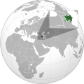
File:Azerbaijan with Nagorno Karabakh region.svg
From Wikimedia Commons, the free media repository
Jump to navigation
Jump to search

Size of this PNG preview of this SVG file: 600 × 600 pixels. Other resolutions: 240 × 240 pixels | 480 × 480 pixels | 768 × 768 pixels | 1,024 × 1,024 pixels | 2,048 × 2,048 pixels | 689 × 689 pixels.
Original file (SVG file, nominally 689 × 689 pixels, file size: 578 KB)
File information
Structured data
Captions
Captions
Add a one-line explanation of what this file represents
Карта Азербайджана (с регионом Нагорного Карабаха) на карте мира.
Summary
[edit]| DescriptionAzerbaijan with Nagorno Karabakh region.svg |
Azərbaycanca: Azərbaycan və Dağlıq Qarabağ - dünyanın xəritədə yeri English: Map of Azerbaijan (with Nagorno-Karabakh region) on the map of the world. Esperanto: Azerbajĝano kun Montara Karabaĥo sur mapo de la mondo Español: Azerbaiyán con Nagorno Karabaj en una mapa del mundo |
| Date | |
| Source | Self-made from Azerbaijan (orthographic projection).svg |
| Author | User:Interfase + User:AndLikeThings |
| Public domainPublic domainfalsefalse |
| I, the copyright holder of this work, release this work into the public domain. This applies worldwide. In some countries this may not be legally possible; if so: I grant anyone the right to use this work for any purpose, without any conditions, unless such conditions are required by law. |
File history
Click on a date/time to view the file as it appeared at that time.
| Date/Time | Thumbnail | Dimensions | User | Comment | |
|---|---|---|---|---|---|
| current | 08:49, 24 November 2020 |  | 689 × 689 (578 KB) | Golden (talk | contribs) | add a white dotted border around NKR |
| 08:46, 24 November 2020 |  | 689 × 689 (578 KB) | Golden (talk | contribs) | Fix the borders of other countries; add more detail to new NKR | |
| 17:23, 15 November 2020 |  | 551 × 551 (462 KB) | RufinaFridwald (talk | contribs) | Updating Karabagh related maps | |
| 12:40, 10 November 2020 |  | 551 × 551 (421 KB) | Ratherous (talk | contribs) | Reverted to version as of 14:32, 4 November 2020 (UTC) User blocked. Wait on the change until boundaries are clear | |
| 14:11, 5 November 2020 |  | 551 × 551 (462 KB) | CastorAeolus (talk | contribs) | Reverted to version as of 11:34, 27 October 2020 (UTC) No I won't. | |
| 14:32, 4 November 2020 |  | 551 × 551 (421 KB) | MrLune (talk | contribs) | Reverted to version as of 18:00, 13 December 2019 (UTC) Wait the war end for map edit | |
| 11:34, 27 October 2020 |  | 551 × 551 (462 KB) | CastorAeolus (talk | contribs) | Update | |
| 18:00, 13 December 2019 |  | 551 × 551 (421 KB) | Goran tek-en (talk | contribs) | Added border for South Sudan as requested by {{u|Maphobbyist}} | |
| 08:04, 27 April 2012 |  | 551 × 551 (571 KB) | Interfase (talk | contribs) | {{Information |Description ={{en|1=Map of Azerbaijan (with Nagorno-Karabakh region) on the map of the world.}} |Source =Self-made from Azerbaijan (orthographic projection).svg |Author ... |
You cannot overwrite this file.
File usage on Commons
The following 3 pages use this file:
- Commons:Graphic Lab/Map workshop/Archive/2019
- File:Azerbaijan (orthographic projection with inset).svg (file redirect)
- File:Azerbaijan with Artsakh.svg (file redirect)
File usage on other wikis
The following other wikis use this file:
- Usage on az.wikipedia.org
- Usage on en.wikipedia.org
- Usage on fr.wikipedia.org
- Usage on incubator.wikimedia.org
- Usage on ru.wikipedia.org
- Usage on www.wikidata.org
- Usage on zh.wikipedia.org
Metadata
This file contains additional information such as Exif metadata which may have been added by the digital camera, scanner, or software program used to create or digitize it. If the file has been modified from its original state, some details such as the timestamp may not fully reflect those of the original file. The timestamp is only as accurate as the clock in the camera, and it may be completely wrong.
| Width | 551pt |
|---|---|
| Height | 551pt |