File:Axis Occupation of France.png
Jump to navigation
Jump to search

Size of this preview: 632 × 600 pixels. Other resolutions: 253 × 240 pixels | 506 × 480 pixels | 809 × 768 pixels | 1,079 × 1,024 pixels | 2,000 × 1,898 pixels.
Original file (2,000 × 1,898 pixels, file size: 223 KB, MIME type: image/png)
Captions
Captions
Add a one-line explanation of what this file represents
| Description |
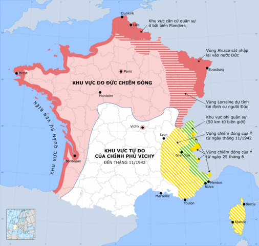
Map France under German occupation (1940-44) English: Occupation zones of France during the Second World War, German version |
| Date | (UTC) |
| Source | |
| Author |
Rama for zones
|
| This is a retouched picture, which means that it has been digitally altered from its original version. Modifications: Vinamisation. The original can be viewed here: France map Lambert-93 with regions and departments-occupation-de.svg:
|
This file is licensed under the Creative Commons Attribution-Share Alike 3.0 Unported license.
- You are free:
- to share – to copy, distribute and transmit the work
- to remix – to adapt the work
- Under the following conditions:
- attribution – You must give appropriate credit, provide a link to the license, and indicate if changes were made. You may do so in any reasonable manner, but not in any way that suggests the licensor endorses you or your use.
- share alike – If you remix, transform, or build upon the material, you must distribute your contributions under the same or compatible license as the original.
Original upload log
[edit]
This image is a derivative work of the following images:
- File:France_40-44.png licensed with PD-self
- 2009-03-19T16:31:40Z Ziegelbrenner 3176x2869 (471764 Bytes) {{Information |Description={{en|1=== Summary == {{Information |Description= Map France under German occupation (1940-44) |Source=Created by the author, adapted from english version of [[w:en:User:Adam Carr]] |Date= Set 30th 2
- File:France_map_Lambert-93_with_regions_and_departments-occupation-de.svg licensed with Cc-by-sa-3.0,2.5,2.0,1.0, GFDL
- 2008-11-28T16:28:27Z Rama 2000x1898 (921714 Bytes)
- 2008-11-28T15:41:48Z Rama 2000x1898 (919318 Bytes) {{Information |Description= |Source= |Date= |Author= |Permission= |other_versions= }}
- 2008-11-28T15:38:26Z Rama 2000x1898 (918966 Bytes) {{Information |Description= |Source= |Date= |Author= |Permission= |other_versions= }}
- 2008-11-28T15:31:55Z Rama 2000x1898 (919375 Bytes)
- 2008-11-28T15:13:26Z Rama 2000x1898 (919384 Bytes) == Summary == {{Location|46|15|00|N|02|06|00|E|scale:10000000}} {{Information |Description={{en|Occupation zones of France during the Second World War, French version}} |Source=Own work *Source of data: NGDC World Data Bank
- 2008-11-28T15:11:37Z Rama 2000x1898 (919386 Bytes) == Summary == {{Location|46|15|00|N|02|06|00|E|scale:10000000}} {{Information |Description={{en|Occupation zones of France during the Second World War, French version}} |Source=Own work *Source of data: NGDC World Data Bank
Uploaded with derivativeFX
File history
Click on a date/time to view the file as it appeared at that time.
| Date/Time | Thumbnail | Dimensions | User | Comment | |
|---|---|---|---|---|---|
| current | 08:26, 7 October 2010 | | 2,000 × 1,898 (223 KB) | Tazadeperla (talk | contribs) | More info added. |
| 16:09, 6 October 2010 |  | 1,301 × 1,235 (359 KB) | Tazadeperla (talk | contribs) | {{Information |Description=Map France under German occupation (1940-44) {{en|Occupation zones of France during the Second World War, German version}} |Source=*File:France_40-44.png *[[:File:France_map_Lambert-93_with_regions_and_departments-occupati |
You cannot overwrite this file.
File usage on Commons
There are no pages that use this file.
File usage on other wikis
The following other wikis use this file:
- Usage on vi.wikipedia.org