File:Atlantic ship tracks ESA389965.tiff

Original file (4,663 × 5,461 pixels, file size: 48.84 MB, MIME type: image/tiff)
Captions
Captions
Summary
[edit]| DescriptionAtlantic ship tracks ESA389965.tiff |
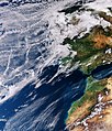
English: The Copernicus Sentinel-3A satellite takes us over the Atlantic Ocean close to Spain and Portugal where the sky not only features clouds but also criss-cross tracks from maritime vessels.
The familiar condensation trails – or contrails – we see in the sky usually come from aircraft, so it might seem strange that ships can also occasionally leave their mark in the sky. This rarely seen maritime twist on aircraft contrails was captured by Sentinel-3A on 16 January 2018. Known as ship tracks, these narrow cloud streaks form when water vapour condenses around small particles that ships emit in their exhaust fumes. They typically form when low-lying stratus and cumulus clouds are present and when the air surrounding the ship is calm. As the image shows, several shipping lanes intersect off the coast of Spain and Portugal. Although the Strait of Gibraltar is a busy shipping lane, with numerous ships travelling in and out of the Mediterranean Sea, there are no ship tracks visible here in the image. Most tracks are several hundreds of kilometres off shore. Like aircraft contrails, ship tracks may also play a role in our climate by reducing the amount of sunlight that reaches Earth’s surface or conversely by trapping the Sun’s radiation in our atmosphere – but this remains an uncertain aspect of climate science. The Copernicus Sentinel-3A satellite carries a suite of sensors including an ocean and land colour instrument, which was used to capture this image, also featured on theEarth from Space video programme. |
| Date | |
| Source | http://www.esa.int/spaceinimages/Images/2018/02/Atlantic_ship_tracks |
| Author | European Space Agency |
| Permission (Reusing this file) |
contains modified Copernicus Sentinel data (2018), processed by ESA,CC BY-SA 3.0 IGO |
| Other versions |
|
| Title InfoField | Atlantic ship tracks |
| System InfoField | Copernicus |
| Set InfoField | Earth observation image of the week |
| Location InfoField | Atlantic |
| Mission InfoField | Sentinel-3 |
| Activity InfoField | Observing the Earth |
Licensing
[edit]- You are free:
- to share – to copy, distribute and transmit the work
- to remix – to adapt the work
- Under the following conditions:
- attribution – You must give appropriate credit, provide a link to the license, and indicate if changes were made. You may do so in any reasonable manner, but not in any way that suggests the licensor endorses you or your use.
- share alike – If you remix, transform, or build upon the material, you must distribute your contributions under the same or compatible license as the original.


|
This image contains data from a satellite in the Copernicus Programme, such as Sentinel-1, Sentinel-2 or Sentinel-3. Attribution is required when using this image.
Attribution: Contains modified Copernicus Sentinel data {{{year}}}
Attribution
The use of Copernicus Sentinel Data is regulated under EU law (Commission Delegated Regulation (EU) No 1159/2013 and Regulation (EU) No 377/2014). Relevant excerpts:
Free access shall be given to GMES dedicated data [...] made available through GMES dissemination platforms [...].
Access to GMES dedicated data [...] shall be given for the purpose of the following use in so far as it is lawful:
GMES dedicated data [...] may be used worldwide without limitations in time.
GMES dedicated data and GMES service information are provided to users without any express or implied warranty, including as regards quality and suitability for any purpose. |
Attribution
File history
Click on a date/time to view the file as it appeared at that time.
| Date/Time | Thumbnail | Dimensions | User | Comment | |
|---|---|---|---|---|---|
| current | 16:55, 9 February 2018 |  | 4,663 × 5,461 (48.84 MB) | Fæ (talk | contribs) | European Space Agency, Id 389965, http://www.esa.int/spaceinimages/Images/2018/02/Atlantic_ship_tracks, User:Fæ/Project_list/ESA |
You cannot overwrite this file.
File usage on Commons
The following 3 pages use this file:
File usage on other wikis
The following other wikis use this file:
- Usage on en.wikipedia.org
- Usage on www.wikidata.org
Metadata
This file contains additional information such as Exif metadata which may have been added by the digital camera, scanner, or software program used to create or digitize it. If the file has been modified from its original state, some details such as the timestamp may not fully reflect those of the original file. The timestamp is only as accurate as the clock in the camera, and it may be completely wrong.
| Width | 4,663 px |
|---|---|
| Height | 5,461 px |
| Bits per component |
|
| Compression scheme | LZW |
| Pixel composition | RGB |
| Orientation | Normal |
| Number of components | 3 |
| Number of rows per strip | 18 |
| Horizontal resolution | 72 dpi |
| Vertical resolution | 72 dpi |
| Data arrangement | chunky format |
| Software used | Adobe Photoshop CC (Macintosh) |
| File change date and time | 10:39, 7 February 2018 |
| Color space | Uncalibrated |
