File:AssyriaEastLands ru.svg
From Wikimedia Commons, the free media repository
Jump to navigation
Jump to search

Size of this PNG preview of this SVG file: 615 × 600 pixels. Other resolutions: 246 × 240 pixels | 492 × 480 pixels | 787 × 768 pixels | 1,050 × 1,024 pixels | 2,099 × 2,048 pixels | 1,800 × 1,756 pixels.
Original file (SVG file, nominally 1,800 × 1,756 pixels, file size: 2.03 MB)
File information
Structured data
Captions
Captions
Add a one-line explanation of what this file represents
Summary
[edit]| DescriptionAssyriaEastLands ru.svg |
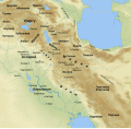
English: Assyria and lands east and north. Ancient-time Persian Gulf coastline (aprox. 1000BC) is dashed. Created with Generic Mapping Tools, Gimp and Inkscape. Used topographic data from NGDC (http://www.ngdc.noaa.gov/mgg/topo/gltiles.html)
Русский: Ассирия и земли к востоку и северу от неё. Береговая линия Персидского залива дана на момент I тыс. до н. э. и не соответствует нынешней, поэтому обведена пунктиром. Создано при помощи Generic Mapping Tools, GIMP и Inkscape. Использованы данные высот NGDC (http://www.ngdc.noaa.gov/mgg/topo/gltiles.html) |
| Date | |
| Source | Own work |
| Author | Anton Gutsunaev |
Licensing
[edit]I, the copyright holder of this work, hereby publish it under the following license:
This file is licensed under the Creative Commons Attribution-Share Alike 3.0 Unported license.
- You are free:
- to share – to copy, distribute and transmit the work
- to remix – to adapt the work
- Under the following conditions:
- attribution – You must give appropriate credit, provide a link to the license, and indicate if changes were made. You may do so in any reasonable manner, but not in any way that suggests the licensor endorses you or your use.
- share alike – If you remix, transform, or build upon the material, you must distribute your contributions under the same or compatible license as the original.
File history
Click on a date/time to view the file as it appeared at that time.
| Date/Time | Thumbnail | Dimensions | User | Comment | |
|---|---|---|---|---|---|
| current | 17:23, 28 January 2009 |  | 1,800 × 1,756 (2.03 MB) | Anton Gutsunaev~commonswiki (talk | contribs) | поправил Гизельбунду |
| 04:44, 28 January 2009 |  | 1,800 × 1,756 (2.03 MB) | Anton Gutsunaev~commonswiki (talk | contribs) | added more labels, fixed existing. Fixed Persian Gulf. | |
| 05:53, 27 January 2009 |  | 1,800 × 1,756 (2.01 MB) | Anton Gutsunaev~commonswiki (talk | contribs) | fix broken labels | |
| 05:47, 27 January 2009 |  | 1,800 × 1,756 (2.01 MB) | Anton Gutsunaev~commonswiki (talk | contribs) | {{Information |Description={{en|1=Assyria and eastern lands}} {{ru|1=Ассирия и земли к востоку от неё}} |Source=Own work by uploader |Author=Anton Gutsunaev |Date=27 January 2009 |Permission= |other_versi |
You cannot overwrite this file.
File usage on Commons
There are no pages that use this file.
File usage on other wikis
The following other wikis use this file:
- Usage on pl.wikipedia.org
- Usage on ru.wikipedia.org
- Usage on sl.wikipedia.org
Structured data
Items portrayed in this file
depicts
some value
27 January 2009
image/svg+xml
9b05963165d4ec4db55f38f9fe273b220cfce09b
2,123,942 byte
1,756 pixel
1,800 pixel
Hidden categories: