File:AMH-5187-NA Map of the Pescadores and the west coast of Formosa.jpg
Original file (2,400 × 1,875 pixels, file size: 558 KB, MIME type: image/jpeg)
Captions
Captions
Summary
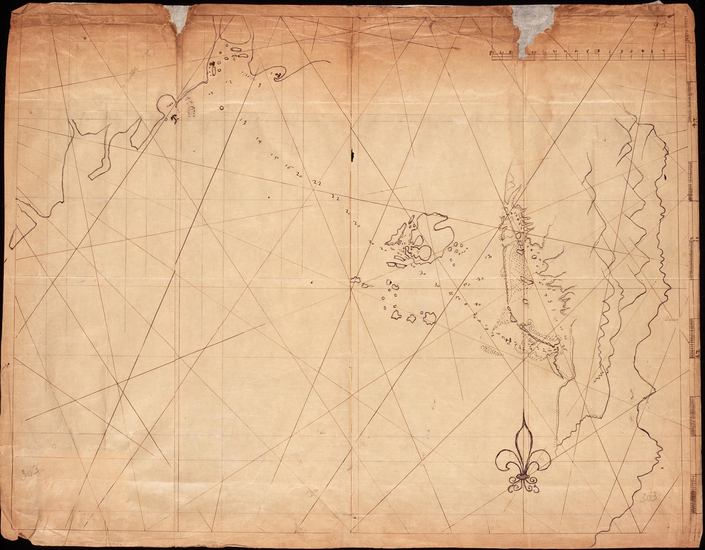
[edit]Nederlands: Kaartje van de Pescadores en de westkust van Formosa
English: Map of the Pescadores and the west coast of Formosa( |
||||||||||||||||||||||||
|---|---|---|---|---|---|---|---|---|---|---|---|---|---|---|---|---|---|---|---|---|---|---|---|---|
| Author |
Creator:Heyndrick Ariensen Lootsman Nederlands: Heyndrick Ariensen Lootsman (landmeter / kaartenmaker)
English: Heyndrick Ariensen Lootsman (land surveyor / mapmaker) |
|||||||||||||||||||||||
| Title |
Nederlands: Kaartje van de Pescadores en de westkust van Formosa
English: Map of the Pescadores and the west coast of Formosa |
|||||||||||||||||||||||
| Description |
Nederlands: Titel in catalogus Leupe (Nationaal Archief): Kaart als voren, hiermee wordt bedoeld de titel van VEL0302: Pascaert, waerin verthoont wort de gelegentheyt van Tayoan enz..
De bovenzijde van de achterkant is beplakt waardoor eventuele notities onleesbaar zijn. Notities verso: Ryks-Archief 's Gravenhage [stempeltje].English: Title in the Leupe catalogue (National Archives): Kaart als voren, referring to the title of VEL0302: Pascaert, waerin verthoont wort de gelegentheyt van Tayoan enz..
The upper portion of the reverse has been repaired and reinforced, rendering any notes illegible. Notes on the reverse: Ryks-Archief 's Gravenhage [stamp]. |
|||||||||||||||||||||||
| Date | between 1624 and 1625 | |||||||||||||||||||||||
| Medium |
Nederlands: pen op japans papier
English: pen on japanese paper |
|||||||||||||||||||||||
| Dimensions | height: 48.5 cm (19 in); width: 37.5 cm (14.7 in) | |||||||||||||||||||||||
| Collection |
|
|||||||||||||||||||||||
| Accession number |
NL-HaNA_4.VEL_303 (old number: VEL0303) |
|||||||||||||||||||||||
| Inscriptions |
-
|
|||||||||||||||||||||||
| Notes |
English: Subjects: chart / map / plan
Nederlands: Onderwerpen: plattegrond / kaart
English: Post: this image is related to a VOC trading post called Peng-Hu |
|||||||||||||||||||||||
| Source/Photographer |
|
|||||||||||||||||||||||
| Permission (Reusing this file) |
|
|||||||||||||||||||||||

| Object location | | View this and other nearby images on: OpenStreetMap |
|---|
File history
Click on a date/time to view the file as it appeared at that time.
| Date/Time | Thumbnail | Dimensions | User | Comment | |
|---|---|---|---|---|---|
| current | 17:34, 10 June 2014 | | 2,400 × 1,875 (558 KB) | HuskyBot (talk | contribs) | == {{int:filedesc}} == {{Artwork |title = {{nl|1=Kaartje van de Pescadores en de westkust van Formosa}} {{en|1=Map of the Pescadores and the west coast of Formosa}} |description = {{nl|1=Titel in catalogus Leup... |
You cannot overwrite this file.
File usage on Commons
The following page uses this file:
File usage on other wikis
The following other wikis use this file:
- Usage on nl.wikipedia.org