File:65424-Sers-Géologie-Leg.pdf
Jump to navigation
Jump to search

Size of this JPG preview of this PDF file: 800 × 566 pixels. Other resolutions: 320 × 226 pixels | 640 × 452 pixels | 1,024 × 724 pixels | 1,280 × 905 pixels | 2,481 × 1,754 pixels.

Original file (2,481 × 1,754 pixels, file size: 12.62 MB, MIME type: application/pdf, 2 pages)
Captions
Captions
Add a one-line explanation of what this file represents
Summary
[edit]| Description |
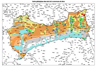
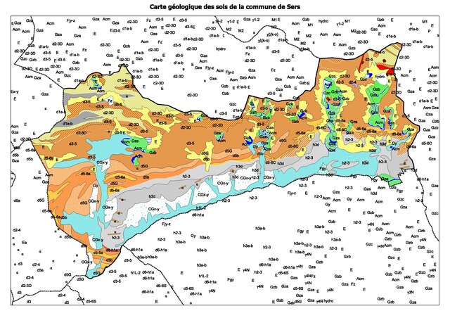
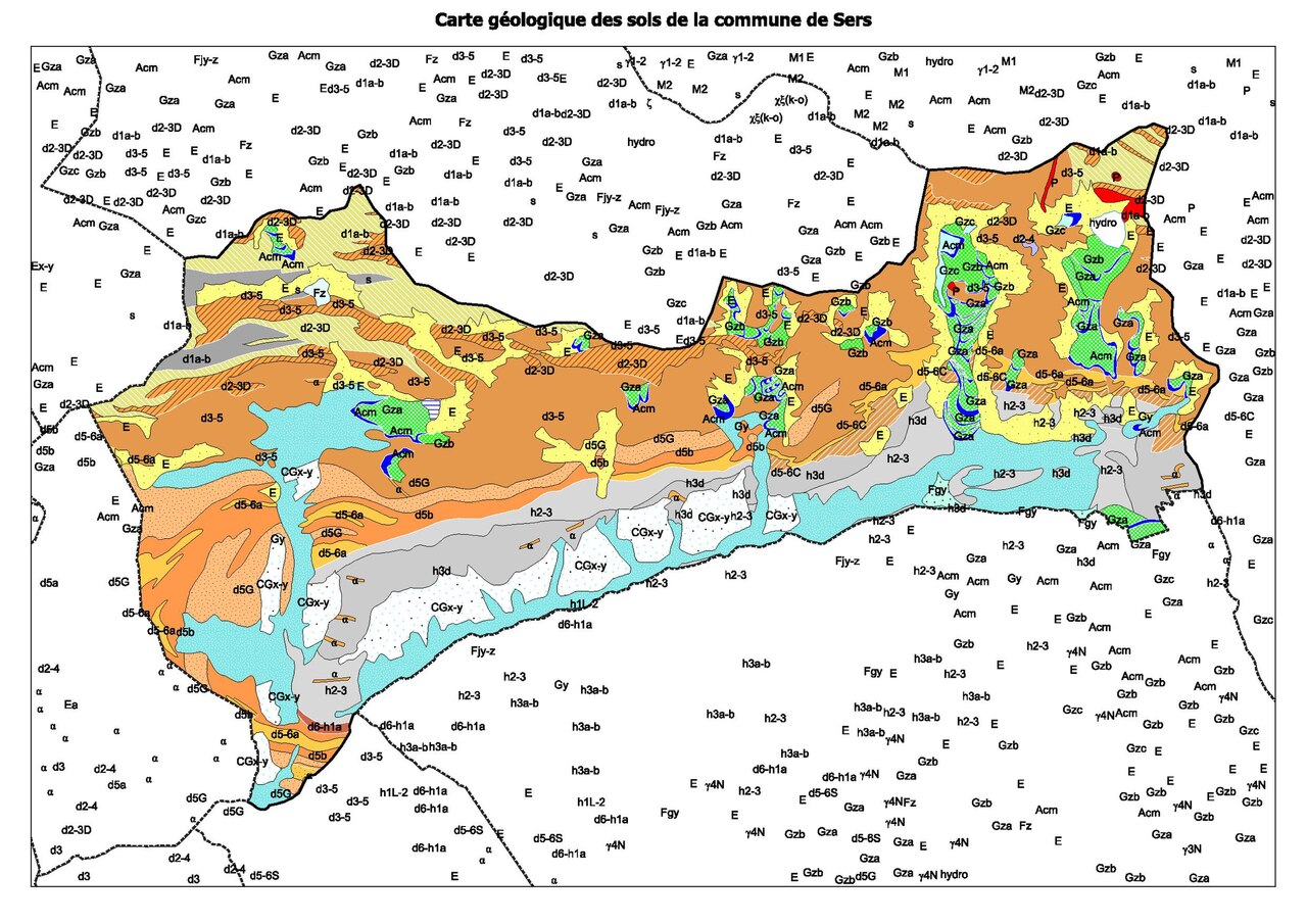
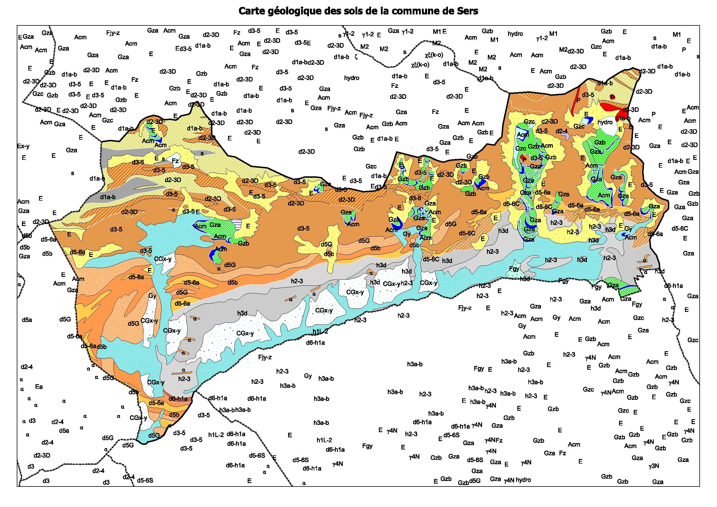
Français : Légende de la carte géologique de la commune de Sers dans le département des Hautes-Pyrénées (France) |
| Date | |
| Source |
Own work. Sources des données : * Découpage administratif communal et départemental : Export simple de janvier 2020 - vérifié et simplifié à 5 m sur le site du portail de données libres du gouvernement français, élaboré avec le concours des contributeurs à OpenStreetMap. * Infrastructures (routes, fer, bâtiments) : : Export openstreetmap de Geofabrik. * Cours d'eau : Cours d'eau - Métropole 2014 - BD Carthage. * Géologie : cartes géologiques départementales à 1/50 000 (Bd Charm-50). Assemblé et enrichi dans fr:QGis. |
| Author | Poudou99 |
Licensing
[edit]I, the copyright holder of this work, hereby publish it under the following license:
This file is licensed under the Creative Commons Attribution-Share Alike 4.0 International license.
- You are free:
- to share – to copy, distribute and transmit the work
- to remix – to adapt the work
- Under the following conditions:
- attribution – You must give appropriate credit, provide a link to the license, and indicate if changes were made. You may do so in any reasonable manner, but not in any way that suggests the licensor endorses you or your use.
- share alike – If you remix, transform, or build upon the material, you must distribute your contributions under the same or compatible license as the original.
File history
Click on a date/time to view the file as it appeared at that time.
| Date/Time | Thumbnail | Dimensions | User | Comment | |
|---|---|---|---|---|---|
| current | 20:04, 17 May 2022 |  | 2,481 × 1,754, 2 pages (12.62 MB) | Poudou99 (talk | contribs) | pattypan 22.03 |
You cannot overwrite this file.
File usage on Commons
There are no pages that use this file.
Metadata
Categories:
- Geological maps of Sers (Hautes-Pyrénées)
- Formation de Cambasque - maps
- Schistes sombres à horizons calcaires et pélites gréseuses - maps
- Calcaires amygdalaires "griottes" (Unité de Chinipro) - maps
- Calcaires gris (Unité de Chinipro) - maps
- Jaspes et ampélites à nodules phosphatés - maps
- Calcaires micritiques clairs - maps
- Carboniferous pyroclastic rocks in Hautes-Pyrénées - maps
- Calcaires sombres à laminites - maps
- Shales calcareux versicolores - maps
- Geological maps of Hautes-Pyrénées (detailed)
- Shales noirs ampéliteux à pyrite - maps
- Namurien: Calcaires, schistes, grès, conglomérats (Carboniferous; Hautes-Pyrénées) - maps
- Calcaires rubanés (Devonian; Hautes-Pyrénées) - maps
- Calcaires manganésifères (Devonian; Hautes-Pyrénées) - maps
- Calcaires limoniteux à goniatites (Devonian; Hautes-Pyrénées) - maps
- Andesites in Hautes-Pyrénées - maps
- Moraine arcs and rows (Pleistocene and Holocene, late Pleistocene glaciation and after Pleistocene glaciation; Hautes-Pyrénées) - maps
- Moraines (Pleistocene Glacial maximum; Hautes-Pyrénées) - maps
- Moraines (Pleistocene glacial retreat; Hautes-Pyrénées) - maps
- Moraines (late Pleistocene glaciation; Hautes-Pyrénées) - maps