File:2016 Sumatra earthquake shakemap.png
Jump to navigation
Jump to search

Size of this preview: 472 × 599 pixels. Other resolutions: 189 × 240 pixels | 378 × 480 pixels | 648 × 823 pixels.
Original file (648 × 823 pixels, file size: 385 KB, MIME type: image/png)
Captions
Captions
Add a one-line explanation of what this file represents
| Description |
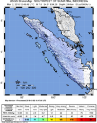
English: Shakemap for 2016 Sumatra earthquake |
|||
| Date | ||||
| Source | https://earthquake.usgs.gov/earthquakes/shakemap/global/shake/10004u1y/ | |||
| Author | United States Geological Survey | |||
| Permission (Reusing this file) |
|
|||
| Other versions | 2016_Sumatra_earthquake_shakemap.svg |
File history
Click on a date/time to view the file as it appeared at that time.
| Date/Time | Thumbnail | Dimensions | User | Comment | |
|---|---|---|---|---|---|
| current | 20:46, 2 March 2016 | | 648 × 823 (385 KB) | ArdWar (talk | contribs) | {{Information |Description ={{en|1=Shakemap for 2016 Sumatra earthquake}} |Source =http://earthquake.usgs.gov/earthquakes/shakemap/global/shake/10004u1y/ |Author =United States Geological Survey |Date =2016-03-02 |Permissio... |
You cannot overwrite this file.
File usage on Commons
The following page uses this file:
File usage on other wikis
The following other wikis use this file:
- Usage on en.wikipedia.org
- Usage on fr.wikipedia.org
- Usage on id.wikipedia.org
- Usage on pl.wikipedia.org
- Usage on zh.wikipedia.org